Scott Martin: Some sun for Alabama through midweek before storms on New Year’s Eve
SUN PLAYS PEEK-A-BOO: The cold front that moved through the area on Monday will be well to our south to start the day today. Unfortunately, skies will continue to stay partly to mostly cloudy throughout the day. The good news is that temperatures will be mild for this time of the year, reaching the mid-50s to the mid-60s.
A strong cold front will be getting its act together west of us on Wednesday, which will put us in the warm, moist air advection out ahead of it. Clouds will build and skies will be mostly cloudy. At this point, rain looks to hold off until well after midnight, so Wednesday looks dry. Highs will be in the lower 60s to right around 70 degrees.
STORMY END FOR 2020: The latest run of the Global Forecast System has slowed the eastward progression of the cold front and holds the scattered rain and storms off from entering central Alabama until the mid to late morning on New Year’s Eve. The much heavier activity will move in during the evening and late night. During this time, a few strong to severe storms may be possible.
The Storm Prediction Center has the southern half of Alabama in a 15% probability for severe thunderstorms to occur within 25 miles of a certain point. The next update will be out later this morning. Timing at this point for the threat of stronger to severe storms looks to be from 3 p.m. Thursday to around 3 a.m. Friday.
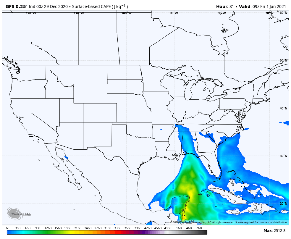
There will be a decent amount of instability as the storm moves through during the late-night and overnight hours. Combine that with decent shear and helicity values forecast at the same time, and there will be a threat of damaging thunderstorm wind gusts up to 60 mph and the potential for a few tornadoes.
We’ll have a better idea later in the day today as the higher-resolution models come into view for the entire event. For now, afternoon highs on Thursday will be in the lower 60s to the lower 70s.
WET START FOR 2021: The cold front will exit the area during the mid-morning, with the rain and storms completely out of Alabama by or just after midday. Once that activity moves out, cooler and drier air will start to move in, but afternoon highs will reach the upper 50s to the lower 70s before that takes place.
THE ALABAMA WEEKEND: We will be sandwiched between the cold front to our southeast with a cold front over the northern Midwest and up into the Great Lakes Region. We’ll have a mix of sun and clouds with afternoon highs reaching the upper 40s to the lower 60s across the state.
Even though we’ll have more sunshine on Sunday, it will actually be a few degrees cooler than we’ll see on Saturday. Highs will be in the upper 40s to the upper 50s.
NICE START TO NEXT WEEK: Monday’s weather will be absolutely fabulous as skies will be mainly sunny with maybe a passing cloud or two. Afternoon highs will be in the lower 50s to the lower 60s.
ON THIS DATE IN 1830: A very heavy snowstorm ushered in the “winter of the deep snow.” The storm produced 30 inches of snow at Peoria, Illinois, and 36 inches at Kansas City, Missouri. Cold and snow continued until the middle of February, causing great suffering among pioneers.
ON THIS DATE IN 1919: The American Meteorological Society was founded at St. Louis, Missouri.
BEACH FORECAST CENTER: Get the latest weather and rip current forecasts for the beaches from Dauphin Island to Panama City Beach, Florida, on our Beach Forecast Center page. There, you can select the forecast of the region you are interested in.
For more weather news and information from James Spann, Scott Martin and other members of the James Spann team, visit AlabamaWx.


