Scott Martin: Almost a carbon-copy forecast for Alabama through next Thursday
REST OF THE WORK WEEK: It’s back to more of a typical late-June pattern for Alabama. We’ll start Thursday off with a decent bit of sunshine, but by the afternoon we’ll have a few isolated to scattered showers and storms fire up during the main heating of the day. Chances will be higher across the southern third of the state, while the northern two-thirds will be mostly dry. Heat will be building out to our west, while temperatures will be on the mild side to our east. Our afternoon highs will be in the mid-80s to the lower 90s from northeast to southwest.
While one or two afternoon showers will be possible Friday, rain chances will be on the slim side and nearly everyone will remain dry. It will be mostly sunny with afternoon highs in the mid to upper 80s. One or two locations may hit 90 degrees or slightly above.
THE WEEKEND: Moisture levels will begin to increase throughout the weekend, which will lead to slightly higher rain chances. A few isolated to scattered afternoon showers and storms will be possible Saturday, but those chances will increase to around a 50/50 shot of scattered storms on Sunday. Saturday’s highs will be in the upper 80s to the lower 90s, but due to the increased cloud cover and increased shower activity, Sunday’s highs will be in the mid to upper 80s.
NEXT WEEK: Next week will be a very repetitive forecast. We’ll have partly sunny days with a daily chance of scattered afternoon to early evening showers and thunderstorms through Thursday. But as we get into Friday, a surface front looks to push into the state that will bring an increase in storm potential. Highs will be in the 80s throughout the week.
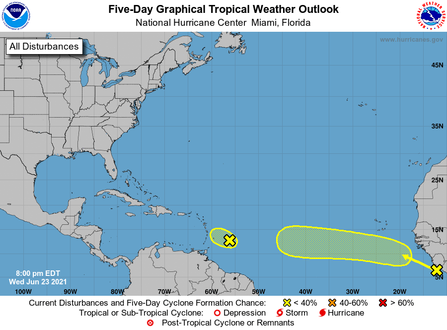
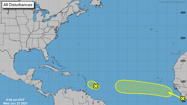
TROPICS: The National Hurricane Center identifies two points of interest out in the Atlantic Ocean, but neither poses a threat to become a tropical cyclone at this juncture.
Shower and thunderstorm activity has increased a bit east of a small area of low pressure a couple of hundred miles east of Barbados. However, increasing upper-level winds are likely to prevent further development of this system while it moves west-northwestward at about 10 mph. This disturbance could produce increased shower activity and some gusty winds when it moves across the Lesser Antilles on Friday. The NHC gives this low only a 10% chance of becoming a depression or tropical storm over the next five days.
A strong tropical wave is expected to emerge off the coast of Africa by today. Some development of this system is possible late this week and into early next week while it moves westward to west-northwestward at about 15 mph across the tropical eastern and central Atlantic Ocean, where ocean temperatures are only marginally conducive for tropical cyclone formation. The NHC gives this wave only a 30% chance of becoming a depression or tropical storm over the next five days.
For more weather news and information from James Spann, Scott Martin and other members of the James Spann team, visit AlabamaWx.


