James Spann: Scattered storms for Alabama later today, dry air for the holiday weekend
James Spann forecasts more rain for many in Alabama from Alabama NewsCenter on Vimeo.
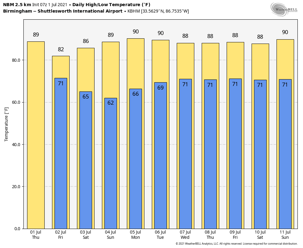
AIR YOU CAN WEAR: A very humid air mass hangs over Alabama this morning and, like Wednesday, we expect scattered to numerous showers and thunderstorms this afternoon and tonight. The chance of any one spot getting wet is 55-65%, and we project a high in the mid 80s with a mix of sun and clouds. The average high for Birmingham on the first of July is 90.
Friday will be a pretty wet day statewide with periods of rain and a few thunderstorms as a rare July cold front pushes into the state from the north. Temperatures will likely hold in the 70s all day. The rain will end Friday evening from north to south as the front continues to push into south Alabama.
FOURTH OF JULY WEEKEND: Unusually dry air for summer will spread into the northern two-thirds of the state late Friday night, setting the stage for a very nice holiday weekend. For most of Alabama, we expect mostly sunny days, cooler nights and lower humidity levels. Highs will be in the 80s and cooler spots could reach the 50s early Sunday morning — amazingly comfortable for the Fourth of July in Alabama.
Scattered showers and storms will remain in the forecast for far south Alabama and the Gulf Coast, but even there the weekend won’t be a washout, and the sun will be out at times.
NEXT WEEK: Monday looks dry for the northern half of the state; then we will bring back some risk of scattered showers and storms during the afternoon and evening hours Tuesday through Friday. There is a good bit of uncertainty in the forecast with a potential tropical system nearby, but at the moment it looks like Alabama will remain on the drier, west side of the system. Highs will be mostly in the mid to upper 80s.
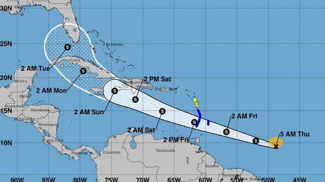
TROPICS: Tropical Storm Elsa formed early this morning in the Atlantic, about 850 miles east/southeast of the Windward Islands. Elsa is the earliest-known fifth named storm on record for the Atlantic basin in the satellite era (1966-present), breaking the record formerly held by Edouard on July 6, 2020. Winds are estimated at 40 mph, and the system is moving west at 25 mph.
Elsa is forecast to move through the Caribbean over the weekend, and the latest National Hurricane Center forecast puts the system near Key West, Florida, late Monday night. But this forecast can and probably will change over the next few days. It is too early to know whether Elsa will move into the Gulf of Mexico, through the Florida Peninsula or recurve east of Florida. All of the possibilities are still on the board. Once we get dropsonde data from hurricane hunters, forecast confidence will improve.
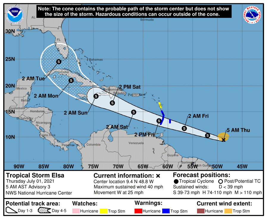
Currently it is forecast to remain below hurricane strength over the next five days due to the quick forward motion and potential interaction with some of the islands along the path.
The rest of the Atlantic basin is quiet.
ON THIS DATE IN 2002: San Antonio, Texas, recorded 9.52 inches of rain to set a new record for its greatest rainfall for the entire month of July.
BEACH FORECAST: Click here to see the AlabamaWx Beach Forecast Center page.
WEATHER BRAINS: You can listen to our weekly 90-minute show any time on your favorite podcast app. This is the show all about weather featuring many familiar voices, including the meteorologists at ABC 33/40.
CONNECT: You can find me on the major social networks:
For more weather news and information from James Spann and his team, visit AlabamaWx.


