Scott Martin: Outstanding Independence Day weekend for Alabama
THE WEEKEND: Today’s weather will be absolutely outstanding as we’ll have mainly sunny skies with only a passing cloud or two. The best part will be the lower temperatures and humidity levels, as highs will range from the lower 80s in the northwest to the upper 80s in the southeast. A stray shower or two will be possible in the very extreme southeastern portions of the state this afternoon, but nearly everyone should stay dry.
The Fourth of July will be warmer, but humidity levels will remain lower and skies will be sunny. Afternoon highs will be in the mid-80s to the lower 90s. There will be no weather issues for viewing fireworks during the evening.
THE WORK WEEK: Moisture levels start to increase Monday, and so do our daily afternoon shower and thunderstorm chances. Skies will be mostly sunny, with a very small chance of a few isolated to scattered showers and storms. Highs will be in the upper 80s to the lower 90s.
Tuesday will be more humid and rain chances will rise to around 50/50 as scattered showers and thunderstorms will be possible, mainly during the afternoon to early evening. Highs will be in the upper 80s to the lower 90s. Elsa will be getting close to making landfall very near to Tampa, Florida.
On Wednesday, odds will be 50/50 for scattered, mainly afternoon to early evening showers and thunderstorms. Afternoon highs will be in the mid to upper 80s. We’ll have no issues from Elsa as she’ll be scooting up the Georgia and South Carolina coastline.
Showers and storms will be likely at times on Thursday, especially during the afternoon and evening. Highs will be in the mid to upper 80s.
Friday will be pretty similar as rain chances will remain high, especially during the afternoon and evening. Highs will be in the mid to upper 80s.
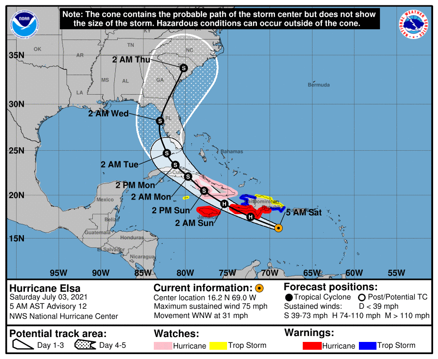
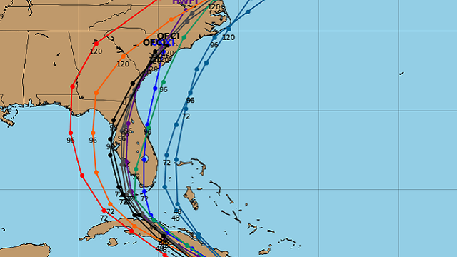
HURRICANE ELSA: As of 4 a.m., the center of Elsa was around 190 miles east-southeast of Isla Beata, Dominican Republic, with maximum sustained winds at 75 mph. Movement was to the west-northwest at 31 mph. Elsa’s movement will slow down later today and on Sunday and will eventually turn northwest Sunday night or early Monday. It will move close to Hispaniola later today and tonight, then approach Jamaica and eastern Cuba on Sunday. By Monday, Elsa will cross over Cuba and will begin to move toward the Florida Straits.
Some slow weakening is expected Sunday and Monday due to the interaction with Cuba, bringing it back down to tropical storm strength. After that, Elsa should remain a tropical storm until its forecasted landfall on the western parts of the Florida Peninsula.
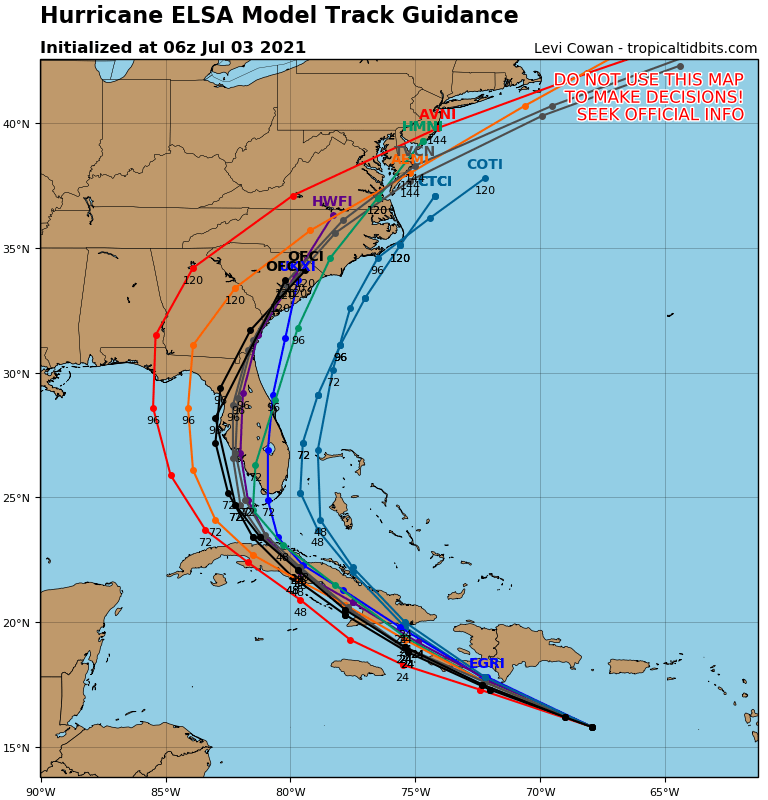
We’ll keep an eye on Elsa. The forecast could change as there is still some uncertainty due to the land interaction with Hispaniola and Cuba.
For more weather news and information from James Spann, Scott Martin and other members of the James Spann team, visit AlabamaWx.


