James Spann: Watching Fred as routine August weather continues for Alabama
James Spann has the midweek forecast for Alabama and the latest on Fred from Alabama NewsCenter on Vimeo.
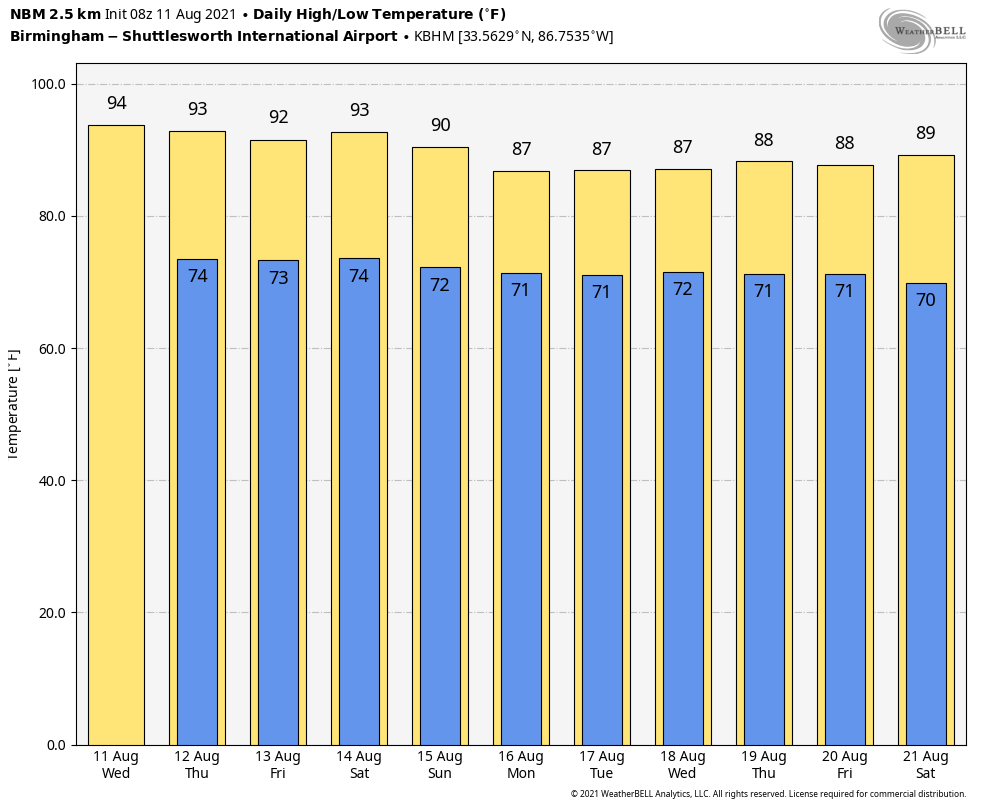
ROUTINE SUMMER WEATHER: Alabama’s weather won’t change much through Friday as an upper ridge stays over the region. Look for partly sunny, hot, humid days with random, scattered, mostly afternoon and evening showers and thunderstorms daily. Highs will be in the low 90s, and the chance of any one spot getting wet is 35-45%. Just what you expect in mid-August.
THE ALABAMA WEEKEND: Not much change is expected — highs of 88-91 Saturday and Sunday with a mix of sun and clouds both days. Scattered showers and storms will be around, generally between noon and 10 p.m. There could be an increase in rain activity across southeast Alabama by Sunday afternoon and Sunday night as Tropical Storm Fred approaches the eastern Florida Panhandle.
NEXT WEEK: The rain coverage on Monday and Tuesday will depend on the behavior of the tropical system. But there is clearly a chance deeper tropical moisture could be in place on these two days with a high coverage of showers and storms; then typical summer weather is likely Wednesday through Friday with a partly sunny sky and scattered, mostly afternoon and evening showers and thunderstorms. Highs will be mostly in the mid to upper 80s through the week.
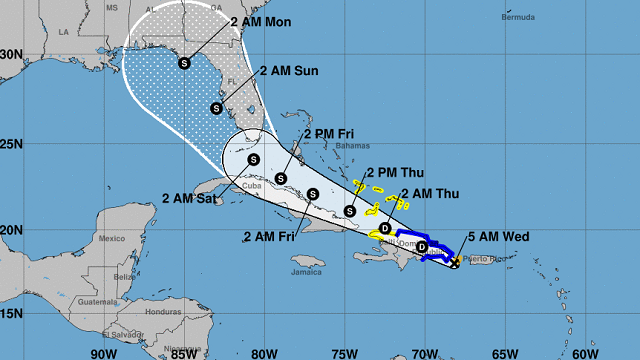
FRED: Potential Tropical Cyclone Six was upgraded to Tropical Storm Fred last night. Winds are 40 mph, and the system will be interacting with Hispaniola today. It will weaken to a tropical depression, but it should survive. The latest forecast from the National Hurricane Center has the system moving into the southeast Gulf of Mexico Saturday, then moving to near Apalachicola late Sunday night as a tropical storm.
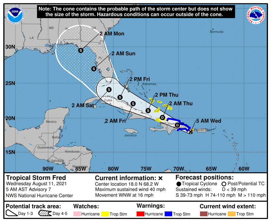
Some notes on Fred this morning:
- For now the NHC is keeping the system under hurricane strength through the time of landfall. An upper-level low and trough near Florida in two to three days could impart increasing west-southwesterly shear and limit intensification.
- The main impact (in terms of wind, rain, storm surge and isolated tornadoes) will be along and east of the circulation center. The current forecast keeps the Alabama Gulf Coast and the western part of the Florida Panhandle (Gulf Shores, Pensacola, Navarre Beach and Destin) on the “good,” west, offshore flow side.
- However, four- and five-day NHC track forecasts have average errors of 175 and 200 miles, respectively. Meaning, of course, the forecast of the track and intensity could easily change in coming days.
- There is a risk of wind and rainfall impacts in Florida beginning Friday in the Keys and spreading northward through portions of the Peninsula Saturday and the Panhandle late Sunday and Sunday night. However, it is too soon to determine the exact timing, location and magnitude of any potential impacts.
- If you have a beach trip planned for this weekend and early next week, monitor Fred’s progress and check updates to the forecast. I would not make any changes to your plans now, but be ready to do that by Friday if needed.
Elsewhere in the tropics, a tropical wave a few hundred miles southwest of the Cabo Verde Islands in the eastern Atlantic is producing showers and thunderstorms just to the west of its axis. Some gradual development is possible over the next several days while the system moves generally westward across the tropical Atlantic at near 20 mph.
ON THIS DATE IN 1999: An F2 tornado touched down in the metropolitan area of Salt Lake City. The tornado lasted 10 minutes and killed one person, injured more than 80 people and caused more than $170 million in damages. It was the most destructive tornado in Utah’s history and awakened the entire state’s population to the fact that the Beehive State does experience tornadoes.
BEACH FORECAST: Click here to see the AlabamaWx Beach Forecast Center page.
WEATHER BRAINS: You can listen to our weekly 90-minute show any time on your favorite podcast app. This is the show all about weather featuring many familiar voices, including the meteorologists at ABC 33/40.
CONNECT: You can find me on the major social networks:
For more weather news and information from James Spann and his team, visit AlabamaWx.


