James Spann: Scattered to numerous showers, storms for Alabama through Saturday
James Spann forecasts more unsettled weather for Alabama from Alabama NewsCenter on Vimeo.
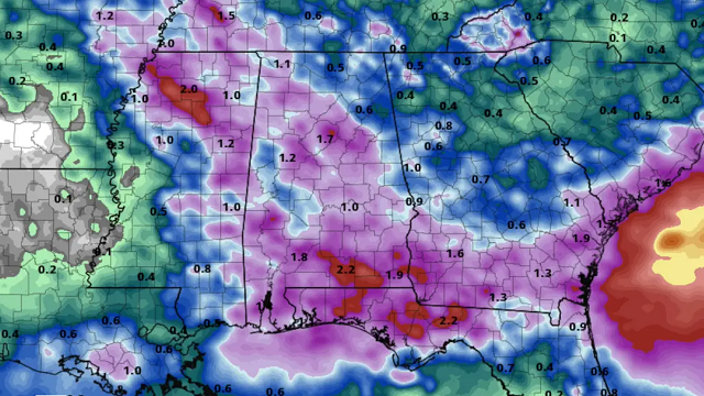
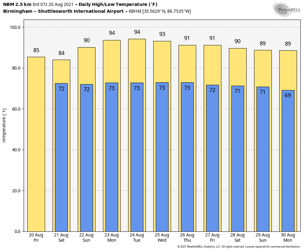
UNSETTLED WEATHER CONTINUES: A unstable air mass will remain in place through Saturday, meaning scattered to numerous showers and thunderstorms both days. Most, but not all, of the rain will come from noon to midnight and, like recent days, the heavier storms will be very efficient rain producers in this environment. Sunshine will be very limited, and temperatures will remain below average, with highs mostly in the mid 80s. On Sunday, an upper ridge begins to rebuild across the region; the sky will be partly sunny, and showers and storms will become more scattered. The chance of any one spot getting wet is 60-70% Friday and Saturday, and 30-40% Sunday afternoon. Heat levels begin to rise Sunday; the high will be around 90 degrees.
NEXT WEEK: Monday and Tuesday will be hot and mostly dry, with only isolated afternoon showers or storms. Afternoon temperatures will rise into the 92- to 95-degree range both days. Then, scattered afternoon and evening showers and thunderstorms will be a little more active Wednesday through Friday as the ridge weakens. Highs over the latter half of the week will be in the upper 80s and low 90s.
FOOTBALL WEATHER: Bring the rain gear if you are headed to a high school football game tonight. It won’t rain at every stadium, but a passing shower or storm is likely; a lightning delay is possible in a few stadiums. Temperatures will be in the 70s.
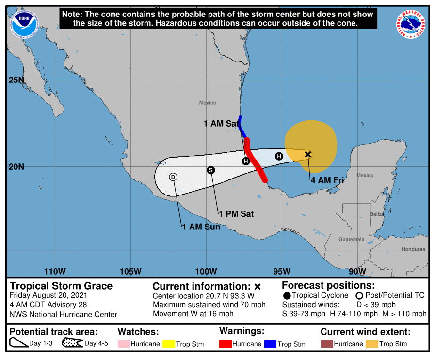
GRACE: Tropical Storm Grace, now with winds of 70 mph in the Bay of Campeche, will move into the coast of Mexico far south of Brownsville, Texas, tonight as a Category 1 hurricane.
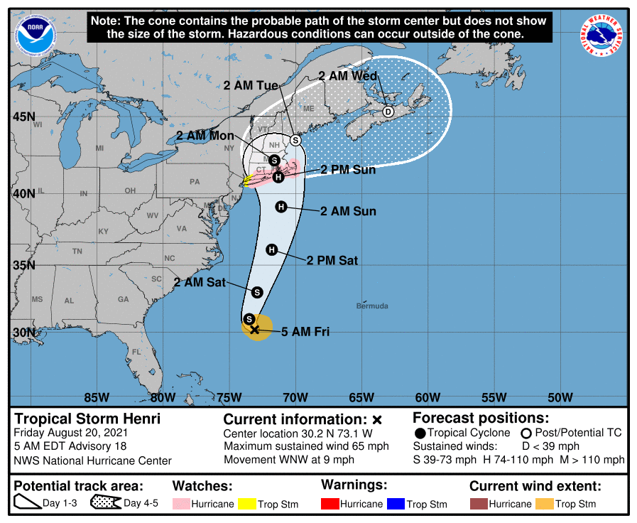
HENRI: Over in the Atlantic, Tropical Storm Henri has sustained winds of 65 mph, and is about 370 miles east of Cape Hatteras. It is expected to become a hurricane Saturday and is headed for New England. A Hurricane Watch has been issued for Long Island from Fire Island Inlet eastward and from Port Jefferson Harbor eastward. A Hurricane Watch has also been issued from New Haven, Connecticut, eastward to Sagamore Beach, Massachusetts, including Nantucket, Martha’s Vineyard and Block Island. Swells from Henri will begin to reach much of the east coast of the U.S. and Atlantic Canada by the end of the week and continue through the weekend. These swells could cause life-threatening surf and rip currents.
Elsewhere in the tropics, a tropical wave over the eastern Atlantic, several hundred miles southwest of the Cabo Verde Islands, is producing a broad area of disorganized showers and thunderstorms. This wave is expected to interact with another wave emerging off the African coast over the next day or two. Afterward, environmental conditions appear marginally favorable for some slow development by the beginning of next week as this system moves gradually to the northwest at 5 to 10 mph. For now the chance of development over the next five days is only 20%.
There are no systems threatening the central Gulf Coast over the next seven to 10 days.
ON THIS DATE IN 1928: A tornado estimated at F4 intensity initially touched down in Winnebago County, Iowa, moved to Freeborn County, Minnesota, and hit the south side of Austin, Minnesota. Five of the six deaths were in Austin, with 60 injuries.
BEACH FORECAST: Click here to see the AlabamaWx Beach Forecast Center page.
WEATHER BRAINS: You can listen to our weekly 90-minute show any time on your favorite podcast app. This is the show all about weather featuring many familiar voices, including the meteorologists at ABC 33/40.
CONNECT: You can find me on the major social networks:
For more weather news and information from James Spann and his team, visit AlabamaWx.


