James Spann: Another hot day for Alabama; watching the tropics

James Spann has a hot midweek forecast for Alabama from Alabama NewsCenter on Vimeo.
HOT SUMMER WEATHER CONTINUES: An upper ridge remains in place across the southern U.S. this morning and will set the stage for another hot summer day in Alabama. We expect a partly to mostly sunny sky with a high between 91 and 95 degrees this afternoon. Showers and storms that form during the heat of the day should be very widely spaced.
The ridge slowly weakens Thursday through the weekend, meaning heat levels gradually will come down and we’ll see a higher number of scattered showers and thunderstorms during the afternoons and evenings. Highs will be in the 87- to 91-degree range each day, and odds of any one spot getting wet will be 30-40%. Like most summer days, the bulk of the scattered showers and storms will come from noon to midnight. Just what you expect in late August in Alabama.
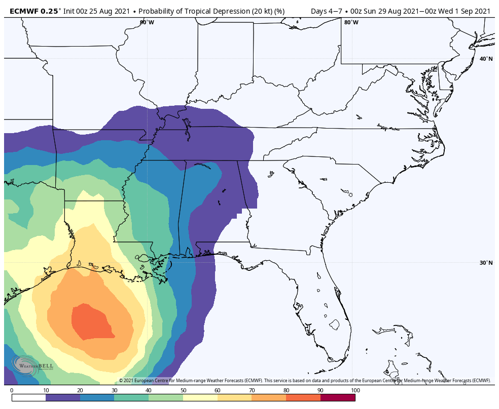
NEXT WEEK: Global models now suggest a tropical system will move inland west of Alabama early in the week, and if this verifies we will be on the wet, east side of the system. Accordingly, this means a higher chance of rain for the first half of the week, but with a tropical system in play five days out, there is great uncertainty. Highs next week will be mostly in the mid to upper 80s.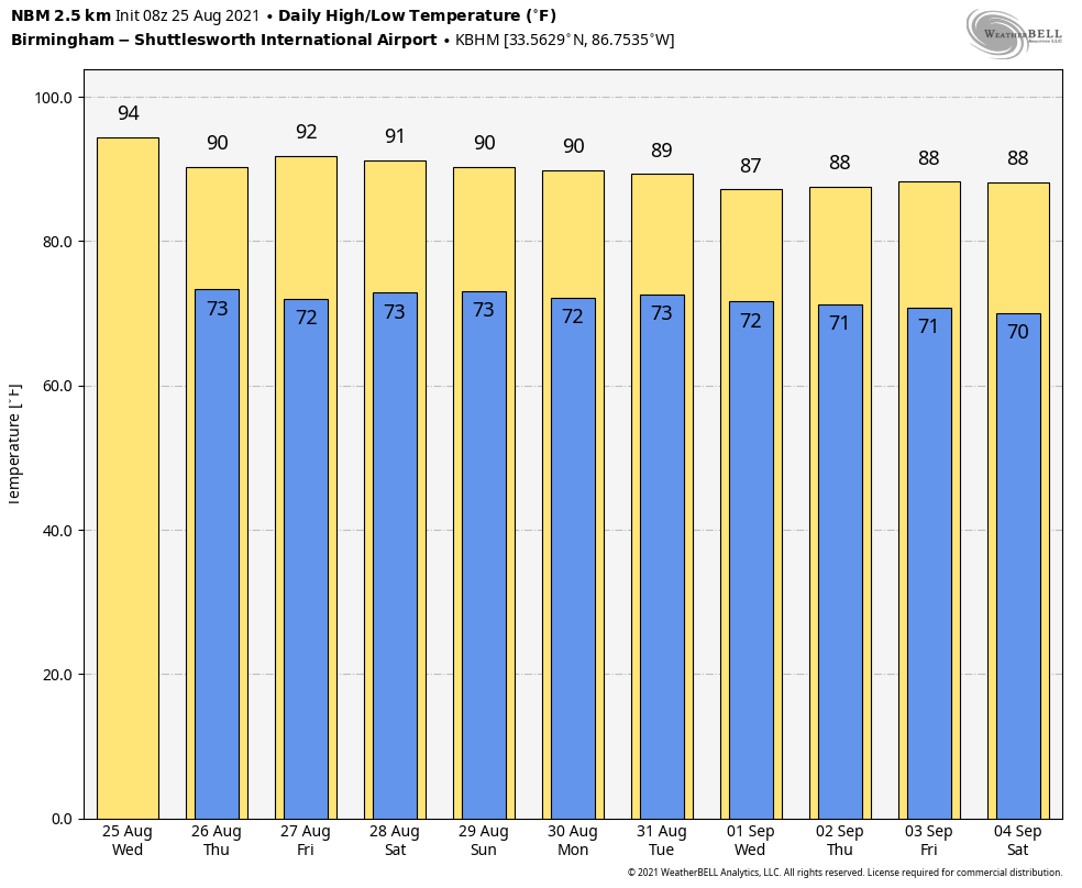 TROPICS: The National Hurricane Center is monitoring three systems this morning. Two are in the Atlantic and are not expected to affect the U.S. The one to watch is the wave in the far southern Caribbean, just off the coast of South America. Environmental conditions are forecast to be conducive for development, and a tropical depression is likely to form late this week or this weekend while the system moves northwestward over the northwestern Caribbean Sea, near or across the Yucatan Peninsula of Mexico, and into the western Gulf of Mexico by Sunday.
Models continue to shift to the right, and the higher landfall probabilities are now on the upper Texas/western Louisiana coasts Monday. But this could easily change over the next few days. There’s no way of knowing the intensity at this point; we will be watching model trends closely.
 ON THIS DATE IN 2017: Hurricane Harvey first made landfall on San Jose Island and then near the Rockport and Fulton, Texas, area around 10 p.m. CDT; it was the first Category 4 hurricane to make landfall along the Texas coast since Carla in 1961. It was the first major hurricane to make landfall in the United States since Wilma in 2005, ending a record 12-year span in which no hurricanes made landfall at the intensity of a major hurricane throughout the country. In a four-day period, many areas received more than 40 inches of rain as the system slowly meandered over eastern Texas and adjacent waters, causing unprecedented flooding. Throughout Texas, approximately 336,000 people were left without electricity and tens of thousands required rescue. Throughout the state, 103 people died in storm-related incidents: 68 from its direct effects, including flooding, and 35 from indirect effects in the hurricane’s aftermath.
BEACH FORECAST: Click here to see the AlabamaWx Beach Forecast Center page.
WEATHER BRAINS: You can listen to our weekly 90-minute show any time on your favorite podcast app. This is the show all about weather featuring many familiar voices, including the meteorologists at ABC 33/40.
CONNECT: You can find me on the major social networks:
For more weather news and information from James Spann and his team, visit AlabamaWx.


