James Spann: Scattered storms for Alabama this evening; dry Thursday, Friday
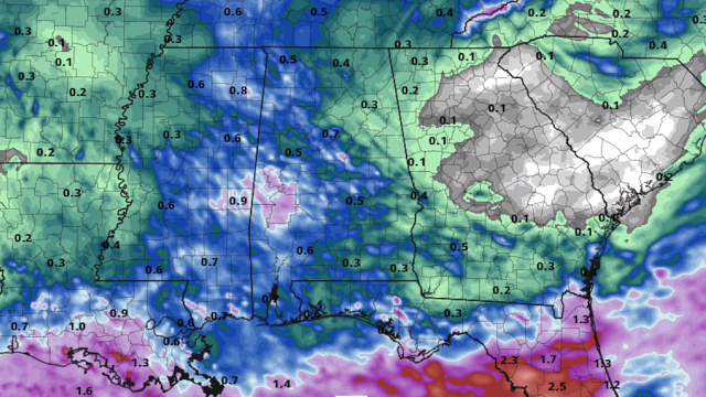
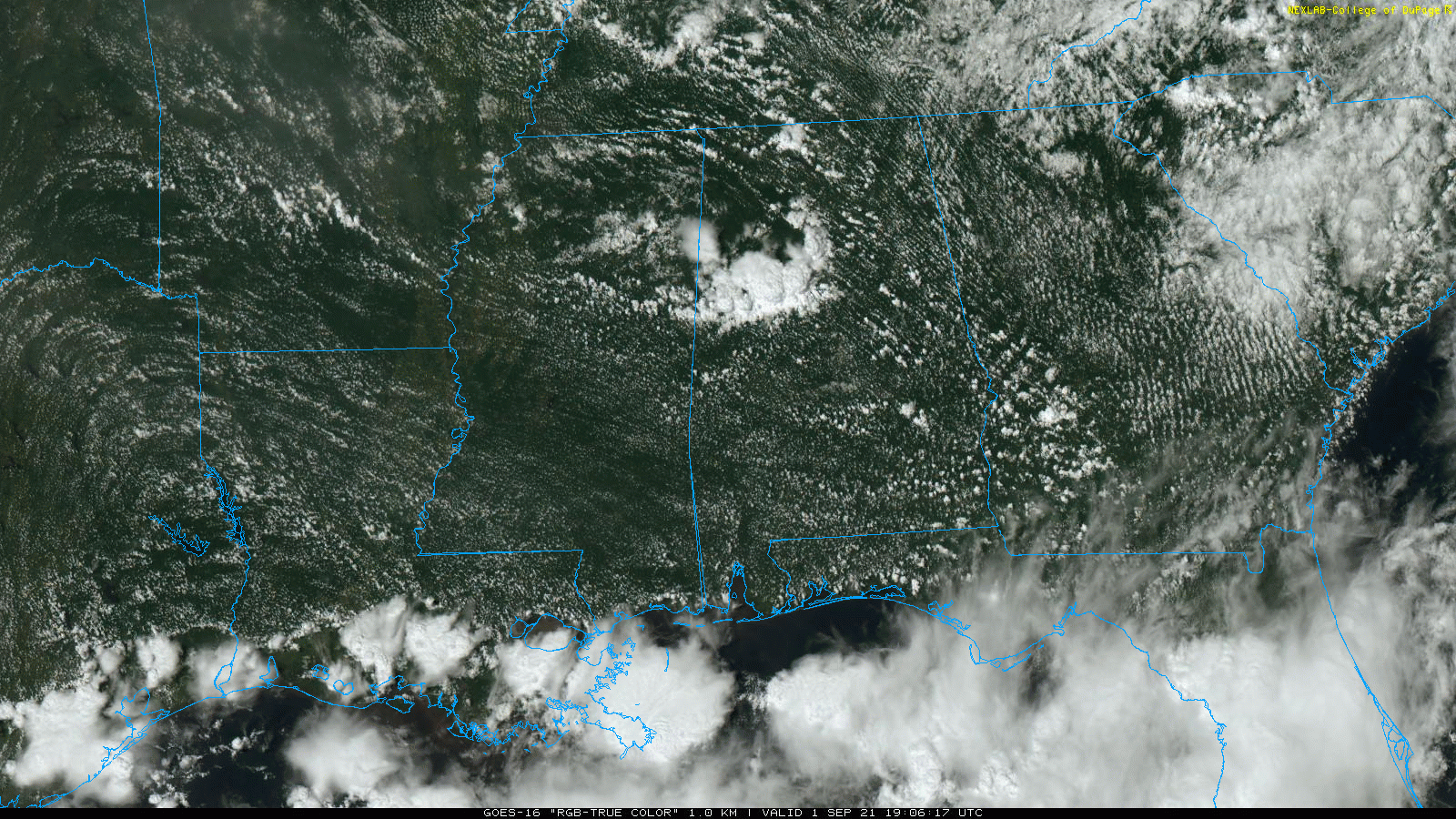
RADAR CHECK: A band of strong thunderstorms is moving southeast through central and west Alabama this afternoon; these storms are producing gusty winds of 25-35 mph, heavy rain and lots of lightning. A few other scattered storms are across the Tennessee Valley; otherwise the sky is partly sunny with temperatures mostly in the upper 80s. Showers and storms will end soon after sunset as a nice push of dry air rolls into the state from the north.
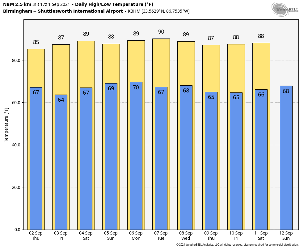
THURSDAY/FRIDAY: Look for mostly sunny, warm days; clear, pleasant nights and lower humidity levels. Highs will be mid 80s Thursday and between 87 and 90 degrees Friday. Some of the normally cooler spots across north Alabama could dip into the upper 50s early Friday morning; otherwise lows will be in the 60s.
LABOR DAY WEEKEND: Saturday will be another warm, dry day with ample sunshine and a high in the upper 80s. We will bring in a chance of scattered showers and thunderstorms late Sunday and Sunday night with a disturbance approaching the state from the north. New model guidance suggests we will need to keep the chance of scattered storms in the forecast Monday, but it certainly won’t rain all day and the sun will be out at times. The high Sunday and Monday will be between 85 and 89 degrees for most communities.
REST OF NEXT WEEK: The weather looks fairly quiet Tuesday through Friday with mostly sunny days and highs in the upper 80s, right at seasonal averages for early September in Alabama.
FOOTBALL WEATHER: UAB will take on Jacksonville State tonight at Cramton Bowl in Montgomery (6:30 p.m. kickoff on ESPN). There is a risk of scattered showers and storms across that part of Alabama during the game. These storms will be random, and there’s no way now of knowing exactly when and where they form. There is a chance one could pass through during the game, so take the rain gear. But it certainly won’t be a washout, and there is a chance it won’t rain a drop. Temperatures will fall from near 86 at kickoff to around 80 by the final whistle.
TROPICS: Tropical Depression Kate will dissipate over the open Atlantic over the next 24 hours. Tropical Storm Larry, in the eastern Atlantic, is forecast to become a major hurricane by Friday night, but it will gain latitude and recurve into the open Atlantic well east of the U.S.
Recent satellite wind data indicates an area of low pressure in the southwestern Caribbean Sea has a well-defined circulation. However, shower and thunderstorm activity remains disorganized and displaced north of the center. Some slow development of this system remains possible over the next day or two if it remains over open water while moving west-northwestward or northwestward at 5 to 10 mph along the coast of Central America. By early next week, the system will have another opportunity for gradual development in the southwestern Gulf of Mexico. Regardless of development, heavy rains are possible across portions of Central America and the Yucatan Peninsula by late this week into the weekend. The National Hurricane Center gives this a 30% chance of developing over the next five days; it’s too early to know whether this will move northward into the Gulf of Mexico.
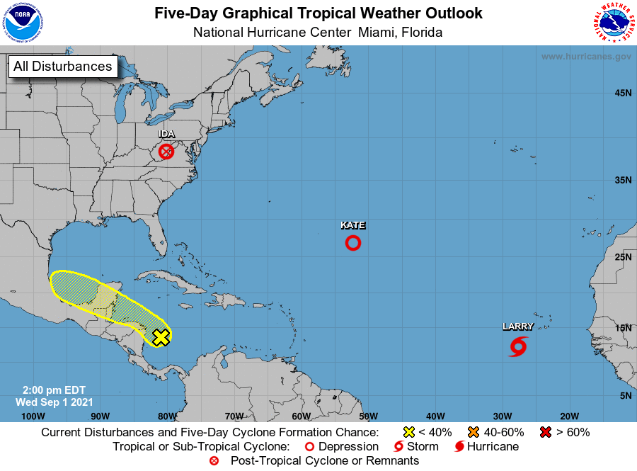
There will be no tropical issues for the central Gulf Coast through the Labor Day weekend.
WELCOME TO METEOROLOGICAL FALL: Meteorologists recognize today as the first day of meteorological fall, which is based on annual temperature cycles and the Gregorian calendar to make a clear transition between the seasons and make for easier record comparisons. However, in terms of astronomy, the new season begins later, at 2:20 p.m. Sept. 22, when the sun is directly over the equator and we have approximately 12 hours of daylight and 12 hours of darkness.
To be clear, it doesn’t magically turn cool in Alabama today. In fact, the hottest temperatures on record here have come in early September (the hottest is 112 degrees, recorded in Centreville on Sept. 5, 1925). But we do expect a few spots across north Alabama to dip into the 50s by early Friday morning for a nice hint of coming attractions.
ON THIS DATE IN 1974: Lt. Judy Neuffer became the first woman to fly a Hurricane Hunter aircraft through the eye of a hurricane.
ON THIS DATE IN 2017: The temperature at downtown San Francisco reached 106 degrees, setting its all-time record high. The previous record was 103 degrees on June 14, 2000.
BEACH FORECAST: Click here to see the AlabamaWx Beach Forecast Center page.
WEATHER BRAINS: You can listen to our weekly 90-minute show any time on your favorite podcast app. This is the show all about weather featuring many familiar voices, including the meteorologists at ABC 33/40.
CONNECT: You can find me on the major social networks:
For more weather news and information from James Spann and his team, visit AlabamaWx.


