Scott Martin: Nice Saturday for Alabama; shower chances rise late Sunday
THIS WEEKEND: Saturday will be a fantastic day with plenty of sunshine and lower humidity. While afternoon highs will make it into the upper 80s to the lower 90s, it will be a more comfortable heat than we are accustomed to in Alabama for late summer.
For the Alabama game in Atlanta, they will be playing with the roof open. While the temperature will be controlled in the stadium, it will be sunny, with the high reaching around 87 degrees.
Auburn will be at home on the Plains with a 6 p.m. kickoff. Skies will be sunny, with the temperature starting off around 81 and steadily dropping into the lower 70s by the final whistle.
Much of the day on Sunday will be rather nice, with mostly sunny skies and highs in the mid 80s to the lower 90s. A cold front will eventually move slowly into the state, bringing shower and thunderstorm chances for extreme northern Alabama by the mid to late afternoon and continuing to move southward through the rest of the day.
LABOR DAY: The cold front will continue to slowly move deeper into the state and eventually stall out around the I-20 corridor. That will keep shower and thunderstorm chances in the forecast for Labor Day. Highs will be in the lower 80s to the lower 90s.
THE WORK WEEK: The cold front begins to move back northward as a warm front on Tuesday, and we’ll hang on to the chance of a few isolated showers during the afternoon over the northern parts of the state. Highs will be in the mid 80s to the lower 90s.
On Wednesday, shower and thunderstorm activity looks to increase as we’ll have a combination of another front heading in our direction from the northwest and the potential of tropical moisture moving up into Alabama from the south and southwest. Highs will be in the mid to upper 80s.
The tropical mischief continues to hang around the Gulf Coast on Thursday, and with the cold front draped across central and south-central Alabama, showers and thunderstorms will continue to be possible. Highs will be in the 80s.
On Friday, the tropical disturbance will continue to skirt eastward along or just south of the Gulf Coast, and that will keep showers and thunderstorms in the forecast for the southern half of the state. Highs will be in the mid to upper 80s.
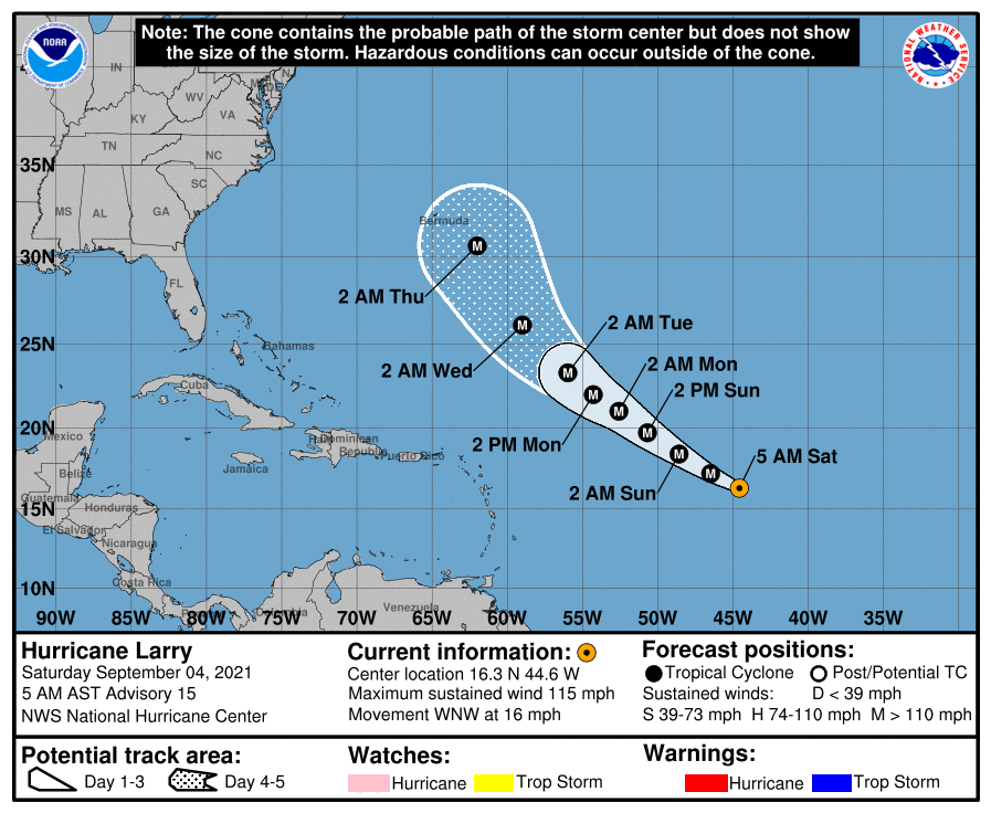
TROPICS: As of the 4 a.m. update from the National Hurricane Center, Hurricane Larry was around 1,140 miles to the east of the Leeward Islands and was moving west-northwest at 16 mph. Maximum sustained winds were at 115 mph, making it a Category 3 hurricane, with a minimum central pressure at 965 millibars. A slightly slower west-northwest to northwest motion is expected during the next few days. Strengthening is forecast over the next day or two, and Larry is expected to remain at major hurricane strength through the early part of next week. It is projected to curve to the north and eventually back to the northeast and will stay away from the U.S., but may come close enough to Bermuda to cause some issues.
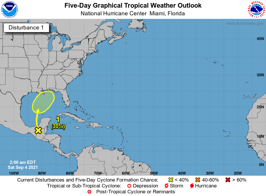
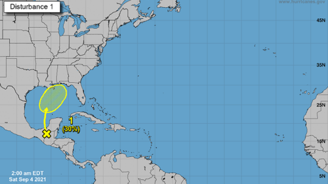
We also have a trough moving over the southern portions of the Yucatán Peninsula that is expected to move over the southern Gulf of Mexico by Sunday and eventually start moving north to northeast. For the next few days, development looks unlikely. By midweek we could see some gradual development, but at this point the NHC is giving it only a 30% chance of becoming a depression within the next five days. It will be something that we’ll have to watch as it will be moving toward the northern Gulf Coast, but the good news at this point is that most members of the intensity guidance keep it as a weak tropical storm or below.
For more weather news and information from James Spann, Scott Martin and other members of the James Spann team, visit AlabamaWx.


