James Spann: Near-record warmth for Alabama Friday; stormy start to the weekend
James Spann forecasts a warming trend, Saturday storms for Alabama from Alabama NewsCenter on Vimeo.
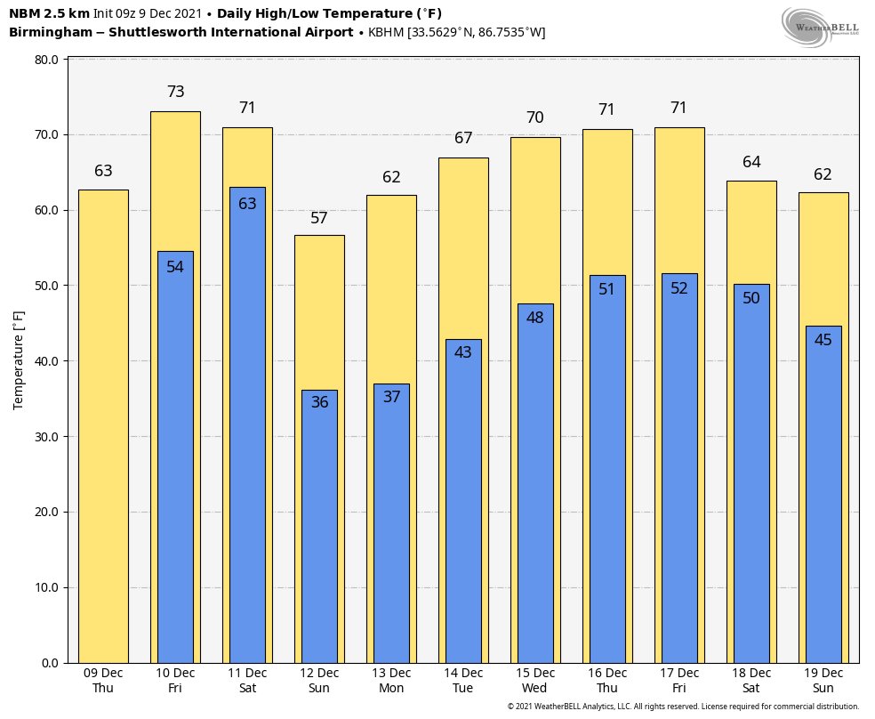
BIG CHANGES AHEAD: With a clear sky, temperatures are mostly in the 30s across the northern half of Alabama this morning, with 40s over the southern counties. Today will be partly sunny with a high in the 60s; clouds will increase late in the day as a surface front near the Gulf Coast begins to lift northward. A few showers are likely late tonight across the state as the front moves through; a rumble of thunder is possible, but no severe storms are expected.
On Friday we will be close to record levels as temperatures soar into the mid 70s. The record high for Birmingham on Dec. 10 is 79, set in 2007. A few scattered showers and thunderstorms are possible, but a decent part of the day will be dry.
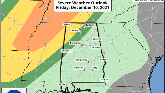
We will watch thunderstorm development northwest of Alabama; there is an enhanced risk (level 3 out of 5) of severe thunderstorms around the Mid-South, including cities like Memphis. A strong tornado can’t be ruled out there during the afternoon and evening. This activity will evolve into a long line of strong to severe thunderstorms that will push into Alabama during the early morning Saturday.
The Storm Prediction Center has defined a slight risk (level 2 of 5) as far east as Athens, Haleyville and Millport for the early morning Saturday and a marginal risk (level 1 of 5) for the rest of the state during the day.
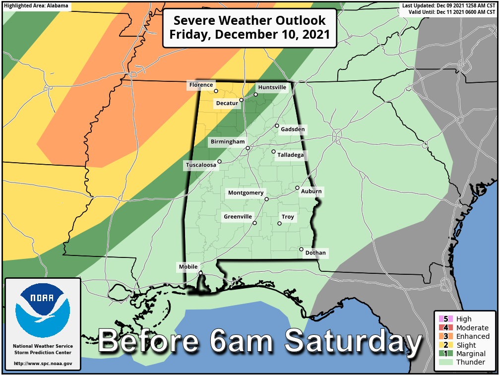
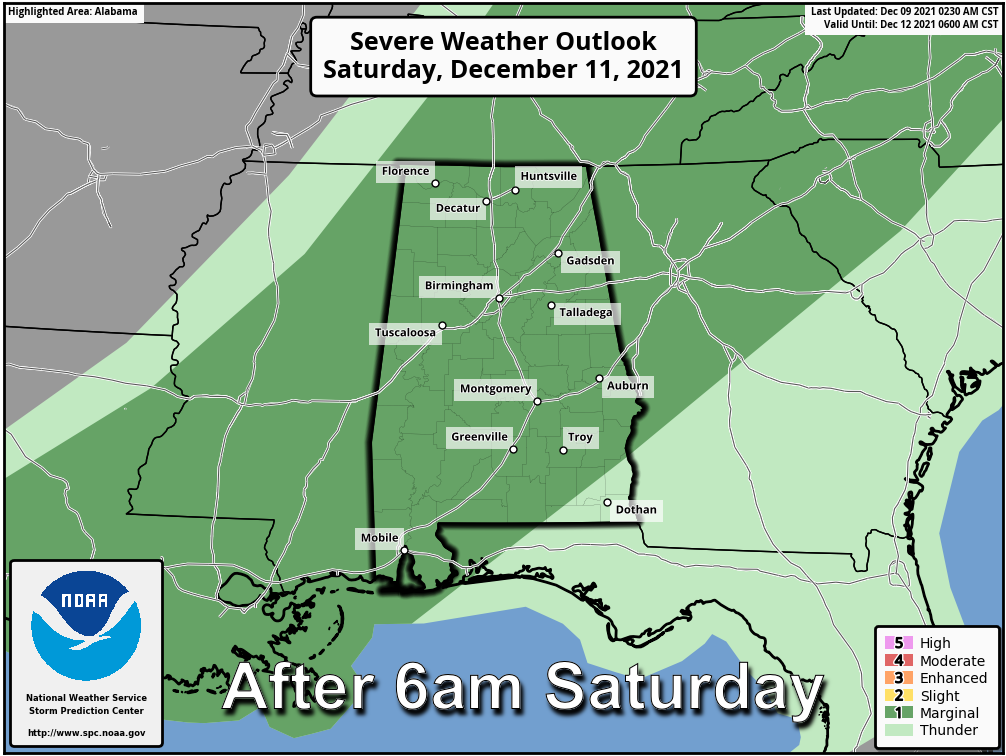 TIMING: The line of strong to severe storms will likely enter the northwest corner of Alabama around 3-4 a.m. Saturday. The line should reach the Birmingham, Anniston, Gadsden and Tuscaloosa areas around 11 a.m.-noon. After noon the line will be south of I-20, pushing into the southern counties by mid to late afternoon.
THREATS: For Alabama, the main threat will come from strong, potentially damaging straight-line winds. A few isolated tornadoes can’t be ruled out, however. Rain will be briefly heavy, but flooding is not expected.
CALL TO ACTION: Be sure you have a way of hearing severe weather warnings. Your primary source should never be an outdoor siren. Have a NOAA Weather Radio in your home properly programmed with a fresh battery in case of power failure. Be sure emergency alerts are enabled on your phone. Review your severe weather plan; identify the safe place and be sure everyone knows where it is. If you live in a mobile home, know where you will go in case you fall in a tornado warning polygon.
Temperatures will go the wrong way Saturday. We start the day between 67 and 70 degrees, but after the line of storms temperatures will fall into the 50s with a cool northwest wind. The sky will clear Saturday night.
Sunday will be sunny and cool, with a high between 55 and 60 degrees.
NEXT WEEK: An upper ridge will build over the Gulf Coast region, and the week looks dry with mild afternoons and cool nights. Afternoon highs will be in the 60s Monday through Wednesday and close to 70 by Thursday and Friday. The latest Climate Prediction Center outlook suggests temperatures will remain above average for Dec. 16-22. There’s still time for a pattern change by Christmas.
ON THIS DATE IN 2003: Although it never threatened land, a subtropical storm became Tropical Storm Peter approximately 700 miles west-northwest of the Cape Verde Islands. Combined with Tropical Storm Odette from earlier in the month, this is the first time since 1887 that two tropical storms formed in the Atlantic Basin in December.
BEACH FORECAST: Click here to see the AlabamaWx Beach Forecast Center page.
WEATHER BRAINS: You can listen to our weekly 90-minute show any time on your favorite podcast app. This is the show all about weather featuring many familiar voices, including the meteorologists at ABC 33/40.
CONNECT: You can find me on the major social networks:
For more weather news and information from James Spann and his team, visit AlabamaWx.


