James Spann: Dry, warmer in Alabama Thursday; some snow early Saturday
COOL MARCH DAY: Temperatures are mostly in the 50s across Alabama this afternoon with a mostly cloudy sky; look for gradual clearing tonight with a low between 38 and 42 degrees. Thursday will be noticeably warmer, with a high in the mid to upper 60s and a partly to mostly sunny sky.
The warming trend continues Friday; we reach the low to mid 70s with a mix of sun and clouds. Then a cold front will bring rain and thunderstorms to the state Friday night. The Storm Prediction Center maintains a slight risk (level 2 out of 5) of severe thunderstorms for areas south of a line from Mobile to Phenix City; there is a marginal risk (level 1 of 5) as far north as Thomasville, Prattville and Roanoke.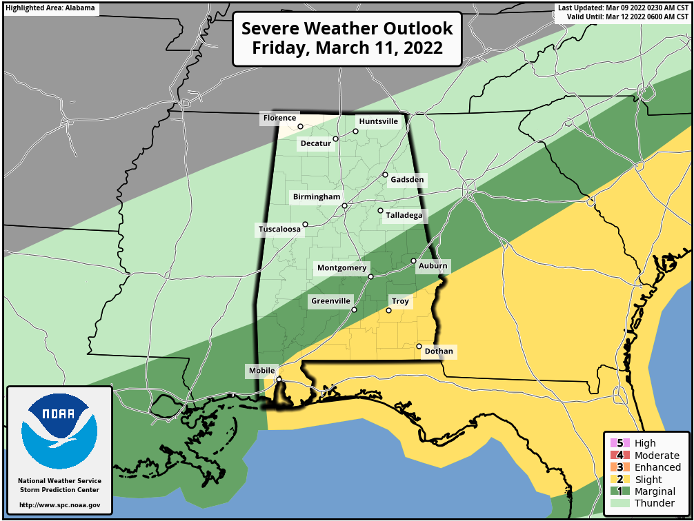 Storms Friday across south Alabama could produce strong winds, and a few tornadoes are possible. Severe storms are not expected over the northern half of the state at this point.
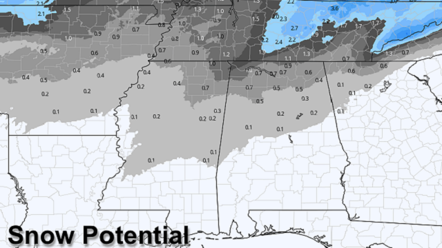
MARCH SNOW: Cold rushes in from the north after midnight Friday night, and the rain will change to snow across much of north Alabama. The latest guidance suggests snow amounts of 1-2 inches are possible over the northwest corner of the state around Florence and Muscle Shoals; elsewhere amounts should be less than 1 inch in areas north of I-20. The snow will accumulate on grassy areas, and amounts will be limited by warm soil temperatures (remember, we will be in the 70s Friday afternoon).
Temperatures early Saturday will drop into the 28- to 34-degree range, and there could be a few isolated slick spots on bridges across the Tennessee Valley of north Alabama. No travel impact is expected at this point for the I-20 corridor (Tuscaloosa-Birmingham-Anniston).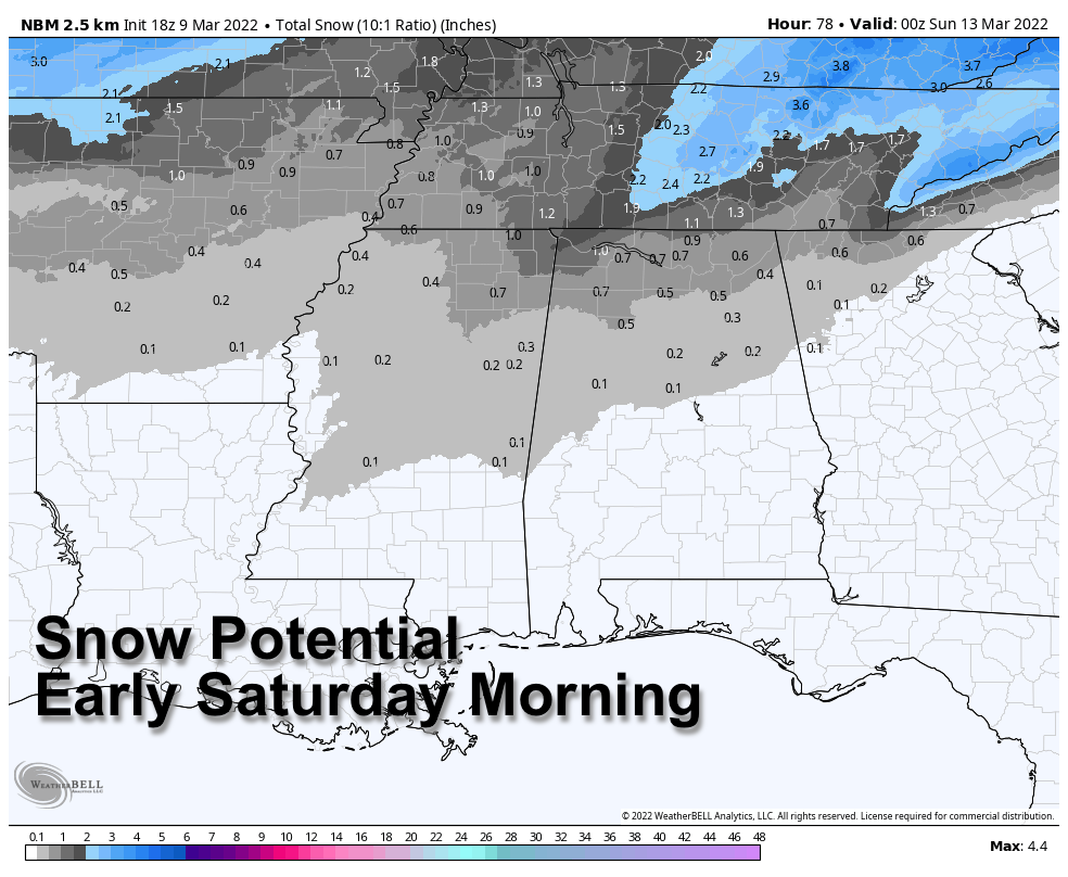 The sky will clear Saturday afternoon, but temperatures won’t get out of the 30s over the northern third of Alabama with wind chill indices hovering around the freezing mark all day. A very significant late-season freeze is likely by early Sunday morning with a clear sky and light wind. Freezing temperatures are likely all the way down to the Gulf Coast, and the range for north and central Alabama will be from 18 to 25 degrees. Growers need to make preparations for this late-season chill.
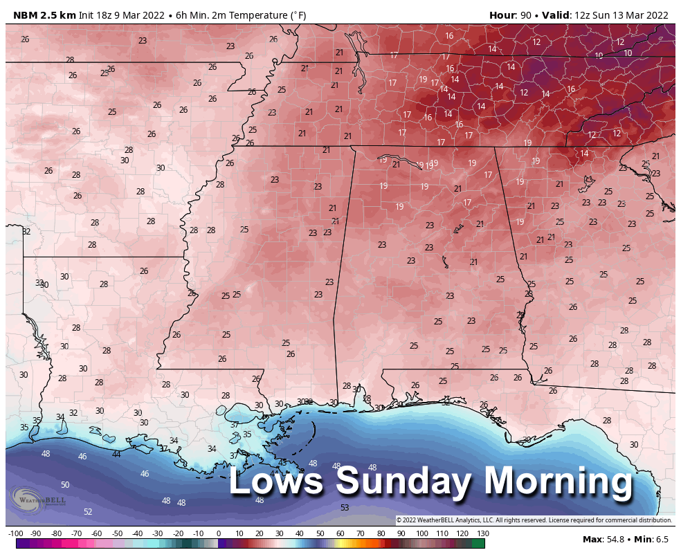 Sunday will be sunny with a high in the 50s as a warming trend begins.
NEXT WEEK: An upper trough will bring a chance of showers to the state Tuesday. The weather looks dry and mild Wednesday and Thursday, with highs rising into the 70s. Another system will bring rain and storms by late Friday or Friday night.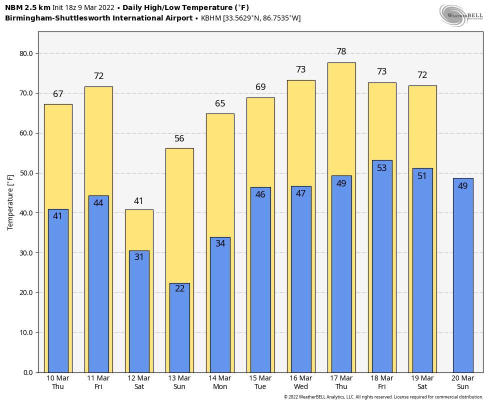 ON THIS DATE IN 1957: An earthquake measuring a magnitude of 8.6 struck the Aleutian Islands of Alaska. A Pacific-wide tsunami was generated that caused damage in Hawaii, but, fortunately, no lives were lost. Hardest hit was the island of Kauai, where houses were destroyed and roads washed away. Waves reached 34.1 feet high at Haena, Hawaii.
BEACH FORECAST: Click here to see the AlabamaWx Beach Forecast Center page.
WEATHER BRAINS: You can listen to our weekly 90-minute show any time on your favorite podcast app. This is the show all about weather featuring many familiar voices, including the meteorologists at ABC 33/40.
CONNECT: You can find me on the major social networks:
For more weather news and information from James Spann and his team, visit AlabamaWx.


