James Spann: Dry Monday for Alabama; stormy weather returns Tuesday, Wednesday
James Spann forecasts a pleasant beginning to the Alabama work week from Alabama NewsCenter on Vimeo.
ONE MORE DRY DAY: Look for a good supply of sunshine across Alabama today with a high in the mid 70s; the average high for Birmingham on April 4 is 72. Clouds will increase tonight ahead of an approaching storm system that will bring unsettled weather to the state Tuesday and Wednesday.
The severe weather potential for both days is complex and somewhat conditional.
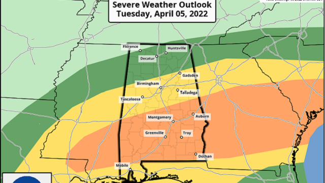
TUESDAY: The Storm Prediction Center has defined an enhanced risk (level 3 out of 5) of severe thunderstorms for much of south Alabama — areas south of a line from Demopolis to Verbena to Roanoke. A slight risk (level 2 of 5) extends as far north as Fayette, Oneonta and Gadsden, and the northern third of the state is under a marginal risk (level 1 of 5).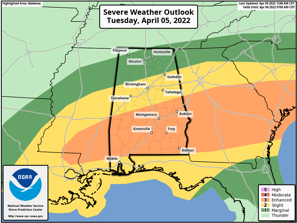 An organized mass of rain and storms will move through the state Tuesday morning, generally in the 6 a.m. to noon time frame. There will be no surface-based instability over the northern half of the state, so the severe weather threat will be mainly confined to south Alabama, where stronger storms will be capable of producing strong winds, hail and possibly a tornado or two. The rain will be heavy at times statewide.
Additional storms could form Tuesday afternoon and evening if the air can recover from the morning convection, and if they develop they could be severe, with potential for hail, strong winds and isolated tornadoes. This is a conditional threat for the afternoon and evening; the main threat window comes from 2 until 8 p.m.
WEDNESDAY: A cold front will bring a line of thunderstorms to the state Wednesday afternoon and evening. While the deepest moisture will be off to the east, there will be lots of instability available, and the storms along the line will be capable of producing large hail and strong, possibly damaging winds. The tornado threat is low due to a unidirectional wind profile that is forecast to be in place across the state. The SPC has defined an enhanced risk (level 3 of 5) for parts of north and central Alabama, including Tuscaloosa, Birmingham, Anniston, Gadsden and Huntsville. The rest of the state is in a slight risk (level 2 of 5).
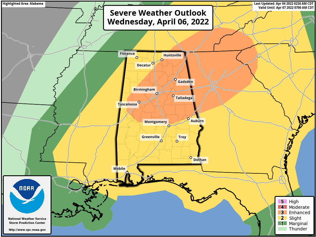 The line of storms will pass through the state between 2 and 9 p.m. Wednesday. Rain totals Tuesday and Wednesday will average 1-3 inches; some flooding could develop in spots.
Be weather aware Tuesday and Wednesday and pay attention to warnings if they are issued. And watch for updates, since the forecast is somewhat complex.
Thursday and Friday will be dry with a significant cooling trend; expect partly sunny days with a high in the mid 60s Thursday and between 57 and 62 degrees Friday — well below average for April in Alabama.
WEEKEND FROST/FREEZE THREAT: We expect lows well down in the 30s Saturday and Sunday mornings over the northern half of the state, with potential for frost, and a freeze for colder spots. Growers will need to watch temperature forecasts both mornings. Otherwise, the weekend will feature lots of sunshine with a high in the low 60s Saturday, followed by low to mid 70s Sunday.
NEXT WEEK: A few showers could creep into the state Tuesday; otherwise much of the week looks mild and dry as an upper ridge forms across the Gulf Coast region.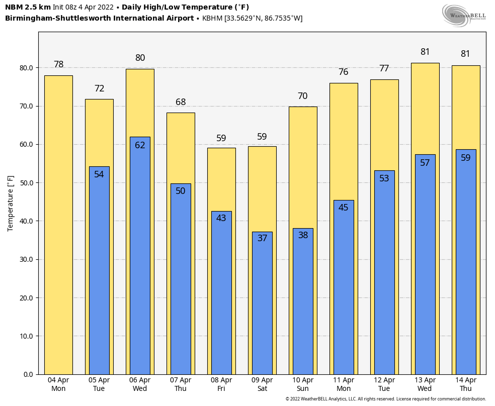 ON THIS DATE IN 1977: A violent F5 tornado tore through northern Birmingham, killing 22 people. The tornado began around 3 p.m., 4 miles northwest of Birmingham near U.S. 78, and then traveled northeast for 15 miles at 60 mph, crossing Interstate 65. At its widest point, the tornado was three-quarters of a mile wide. More than 150 homes were damaged with almost 50 destroyed. Daniel Payne College near U.S. 78 sustained heavy damage from this massive tornado, with estimates over $1 million. The college, opened in 1880, closed its doors later in 1977, likely a result of the enormous cost and amount of damage.
Timely tornado warnings provided by the National Weather Service allowed people to take necessary action well ahead of the approaching storm. The new NOAA Weather Radio program played a huge role in the process. Warnings were broadcast live on the Birmingham KIH-54 transmitter, which had just been implemented five months prior to this event.
Many people do not know that the famous Dr. Theodore Fujita, for whom the Tornado Fujita Intensity Scale is named, followed this massive tornado and supercell thunderstorm from an airplane. After tracking the storm, Fujita surveyed the damage and toyed with the idea of rating the Smithfield tornado an F6.
There were six other tornadoes on this day, five F2 tornadoes and an F3 tornado across north and central Alabama.
On the same day, Southern Airways Flight 242, flying from Huntsville-Madison County Jetport to Hartsfield Atlanta International Airport, crashed in New Hope, Georgia, after suffering hail damage and losing thrust on both engines in a severe thunderstorm. Sixty-three people on the aircraft (including both pilots) and nine people on the ground died; 20 passengers survived, as well as the two flight attendants.
BEACH FORECAST: Click here to see the AlabamaWx Beach Forecast Center page.
WEATHER BRAINS: You can listen to our weekly 90-minute show any time on your favorite podcast app. This is the show all about weather featuring many familiar voices, including the meteorologists at ABC 33/40.
CONNECT: You can find me on the major social networks:
For more weather news and information from James Spann and his team, visit AlabamaWx.


