James Spann: Showers for Alabama today; strong to severe storms Wednesday

James Spann forecasts possible scattered showers for Alabama from Alabama NewsCenter on Vimeo.
MOISTURE LEVELS RISING: We will bring in the chance of scattered showers and thunderstorms across Alabama later today as moisture levels are rising — not an all-day kind of rain, but some spots will see a passing shower or storm later this morning or during the afternoon. Otherwise, expect a mix of sun and clouds with a high in the mid 70s. The weather won’t change much Tuesday; a few random, scattered showers or storms are possible with a high between 76 and 80 degrees.
WEDNESDAY/THURSDAY: Showers will remain scattered during the day Wednesday, but a cold front will bring an organized band of rain and storms into the state Wednesday night into the pre-dawn hours Thursday. The Storm Prediction Center has an enhanced risk (level 3 out of 5) of severe thunderstorms defined for the northwest corner of the state. Most of Alabama is in a level 2 slight risk. The exception is over the southeast counties, where the storms will be weakening; a marginal risk (level 1 of 5) is in place there.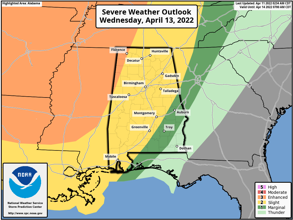 The line of storms will enter northwest Alabama around midnight Wednesday and will pass through the state during the early morning Thursday. For most places, the line will be moving through between midnight and 7 a.m. The core threat will come from strong, potentially damaging straight-line winds. With the surface low well to the north (near the Canadian border), shear values won’t be especially high, and the tornado threat for now looks low. But, as always in a case like this, you can’t rule out an isolated tornado in the line.
The sky becomes partly to mostly sunny Thursday as dry air returns, and Friday looks dry with a good supply of sunshine. The high both days will be in the mid 70s, right at seasonal averages.
THE ALABAMA WEEKEND: A northward-moving warm front will bring rain back into Alabama over the Easter weekend. Showers could begin as early as Saturday afternoon, and periods of rain are likely Saturday night and Sunday as the front stalls out over the region. Some thunder is possible, but for now severe storms are not expected. Highs will remain in the 70s.
NEXT WEEK: Showers remain possible Monday, mainly over north Alabama; then drier air will likely move in during midweek. Highs during the week will be mostly between 76 and 81 degrees.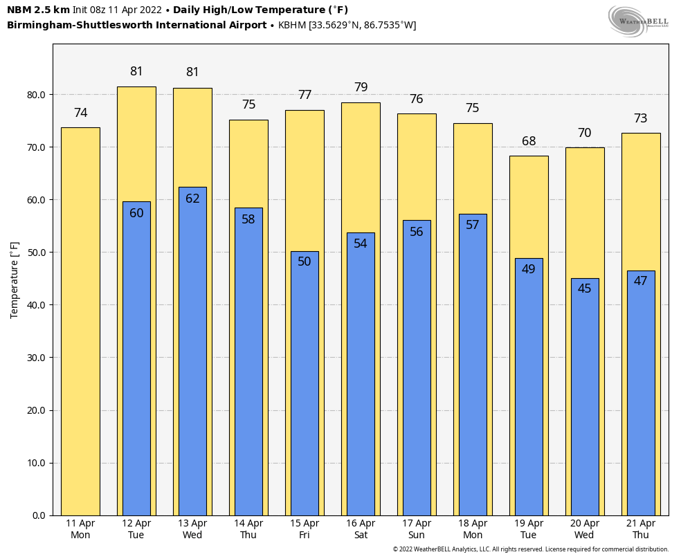 ON THIS DATE IN 1965: The “Palm Sunday Outbreak” consisted of 51 tornadoes, killing more than 250 people and causing more than $200 million damage. Indiana, Ohio and Michigan were hardest hit. Although no F5s were officially reported, at least 22 tornadoes were rated as F3 or F4.
ON THIS DATE IN 2011: A line of severe thunderstorms produced significant wind damage across Alabama. Some of the hardest-hit areas were in Aliceville in Pickens County, Brent in Bibb County and many spots around the Birmingham metro area. Most of the damage reports consisted of single trees or groups of trees that had been uprooted, though there were sporadic reports of structural damage. This was the beginning of an extremely active severe weather month; historic tornado outbreaks would follow on April 15 and April 27.
BEACH FORECAST: Click here to see the AlabamaWx Beach Forecast Center page.
WEATHER BRAINS: You can listen to our weekly 90-minute show any time on your favorite podcast app. This is the show all about weather featuring many familiar voices, including the meteorologists at ABC 33/40.
CONNECT: You can find me on the major social networks:
For more weather news and information from James Spann and his team, visit AlabamaWx.


