James Spann: Humid summer days for Alabama with sun, scattered storms
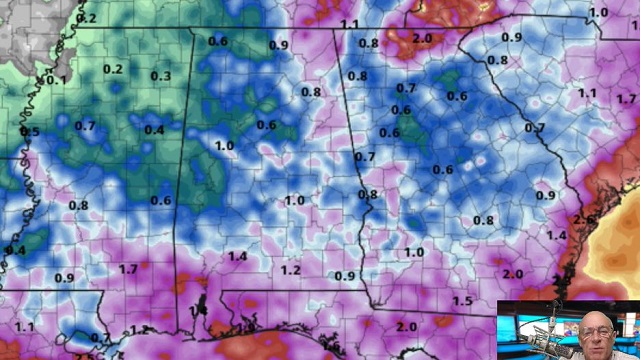
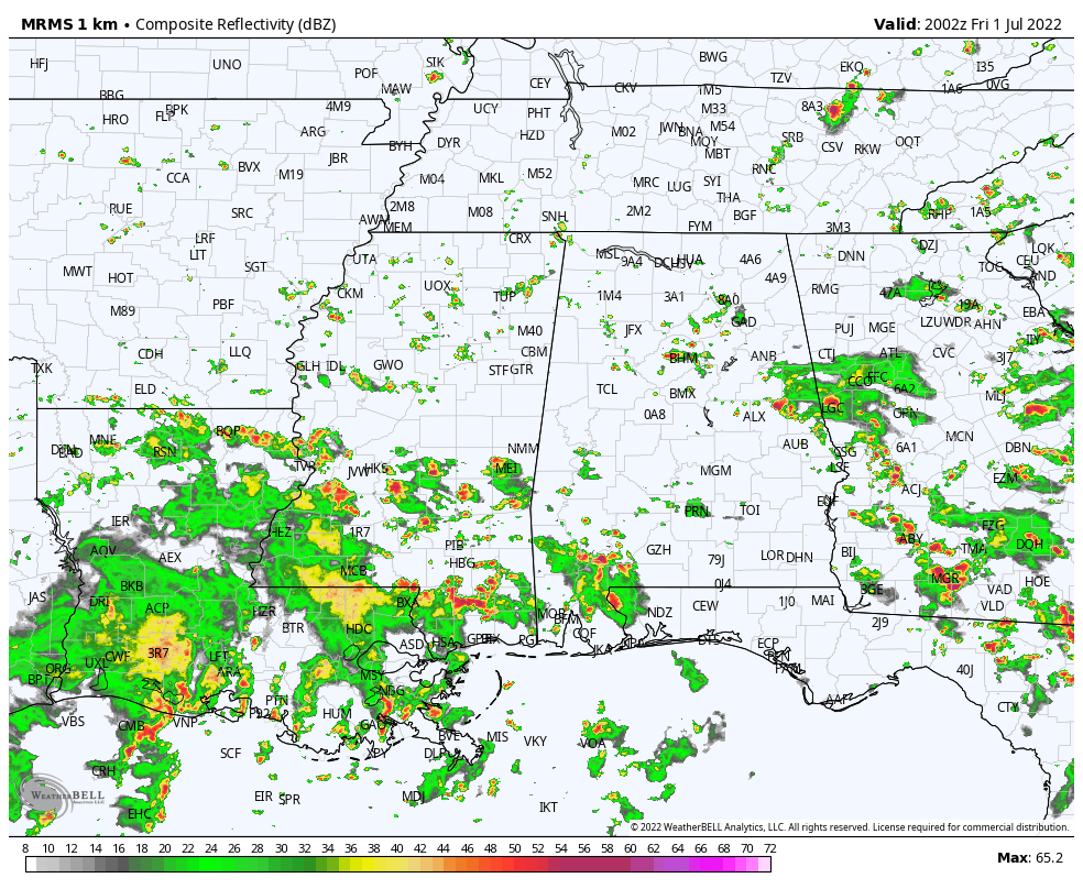
RADAR CHECK: We have the classic case of random showers and thunderstorms this afternoon across Alabama. Showers are moving little, and the heavier storms are producing heavy rain, gusty winds and lots of lightning. Away from the storms, the sky is partly sunny with temperatures between 86 and 90 degrees. Showers and storms will fade away late tonight.
HOLIDAY WEEKEND: We see no real change in the pattern — partly sunny, humid days with scattered, mostly afternoon and evening showers and thunderstorms. Most of the showers will come from 2 until 10 p.m.; odds of any one spot seeing rain are 45-55% Saturday and Sunday and 30-40% Monday. There’s no way of knowing in advance exactly when and where the storms fire up, so if you have an outdoor event planned over the weekend, just watch radar trends. Afternoon highs will be very close to 90 degrees each day.
REST OF NEXT WEEK: Expect partly sunny days, a few scattered storms during the afternoons and evenings and highs in the low 90s, very routine weather for early July in Alabama. TROPICS: Tropical Storm Bonnie, with winds of 40 mph, will move into Central America this evening far south of the U.S. If the system can maintain a low-level circulation over land, it will keep the name Bonnie as it emerges into the Pacific Saturday.
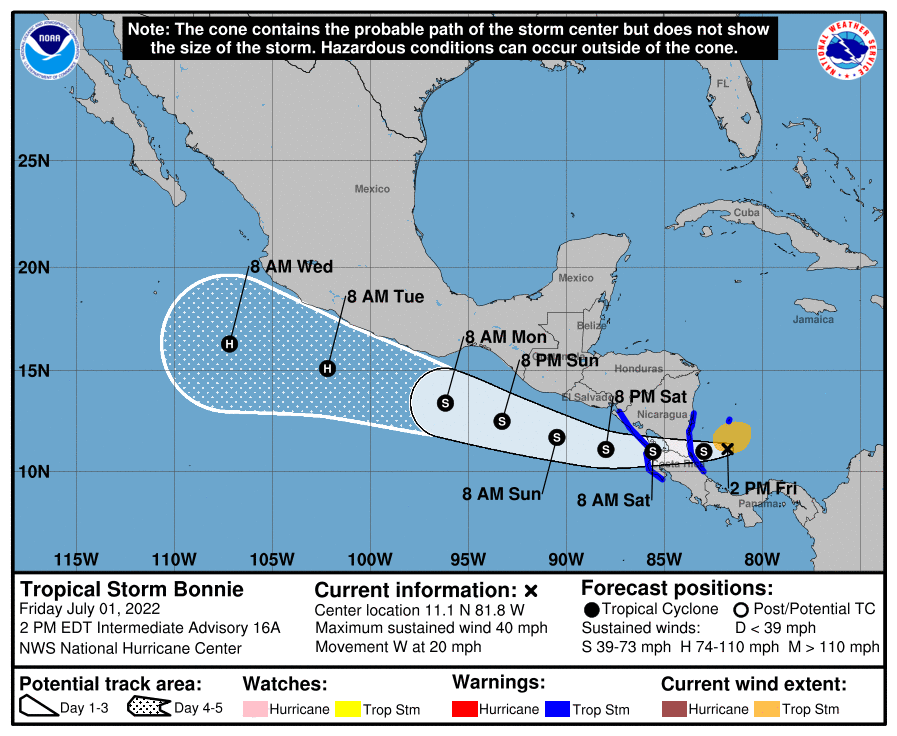 Satellite and radar images along with surface observations indicate that a low-pressure system has formed just off the coast of Savannah, Georgia. Surface pressures are high in this region, and development, if any, of this system should be slow while it drifts northeastward along the Southeast coastline during the next day or so. Regardless of development, this system is expected to produce heavy rains, which could cause flash flooding across portions of southeastern Georgia and the Carolinas through tonight and into Saturday.
A tropical wave over the Windward Islands is producing disorganized showers and thunderstorms. Significant development of this system is not expected while it moves westward into unfavorable conditions over the eastern Caribbean Sea. There are no tropical systems threatening the central Gulf Coast (Gulf Shores to Panama City Beach) over the next seven days.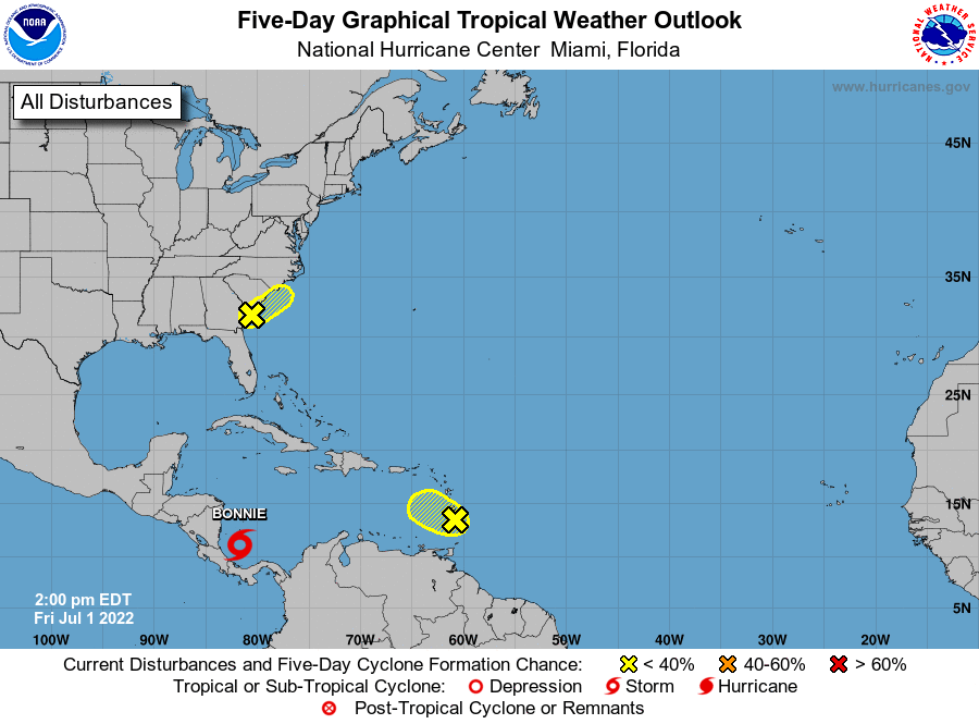 RAIN UPDATE: Here are rain totals since Jan. 1, and the departure from average:
- Birmingham — 40.21 inches (9.8 inches above average)
- Huntsville — 33.78 (4.7 above average)
- Tuscaloosa — 33.65 (5.18 above average)
- Montgomery — 29.61 (2.93 above average)
- Anniston — 29.51 (1.07 above average)
- Muscle Shoals — 29.2 (0.16 above average)
- Dothan — 28.67 (1.58 above average)
- Mobile — 27.89 (5.33 below average)
ON THIS DATE IN 2002: San Antonio, Texas, recorded 9.52 inches of rain to set a new record for its greatest rainfall for the entire month of July.
BEACH FORECAST: Click here to see the AlabamaWx Beach Forecast Center page.
For more weather news and information from James Spann and his team, visit AlabamaWx.


