James Spann: Alabama stays dry through Thursday; watching Ian closely
SUNNY AFTERNOON: The sky is sunny across Alabama this afternoon with temperatures mostly in the 80s, but a cold front is passing through in dry fashion, and tonight should be the coolest night so far this season. We project a low between 46 and 52 degrees early Tuesday over the northern half of the state for a real “fall feel.” Dry and very pleasant weather is the story Tuesday through Thursday with sunny days and clear, cool nights. Highs will be in the mid to upper 70s, with lows well down in the 50s. Cooler spots will visit the 40s over north and central Alabama.
FRIDAY AND THE WEEKEND: The weather will all depend on how Ian behaves once inland. The latest global model data suggests rain could begin over southeast Alabama during the day Friday, spreading northward and westward Friday night into Saturday. We will bring in a chance of rain for most of north and east Alabama Saturday; the highest chance will be over the eastern half of the state. As the remnant low moves away, Sunday looks dry with a good supply of sunshine and a high in the upper 70s. This forecast could easily change as the weekend gets closer.
NEXT WEEK: The week looks quiet and dry with highs between 77 and 81 degrees; lows will be mostly in the 50s.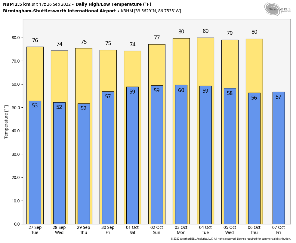 RACE WEEKEND: Periods of rain are likely Saturday at Talladega, but Sunday looks dry with a good supply of sunshine. The high will be in the mid 70s Saturday, followed by upper 70s Sunday. The amount and duration of rain Saturday will depend on Ian’s track inland; we will be much more specific in a day or two.
NOTES ON HURRICANE IAN:
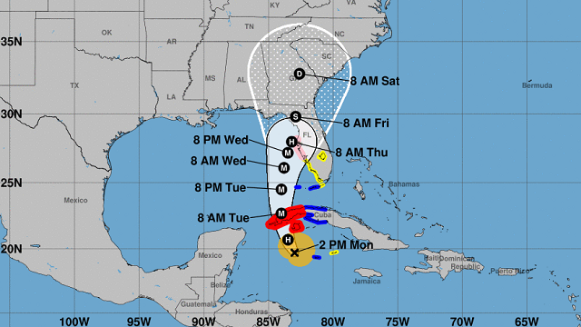
- Ian is now 190 miles southeast of the western tip of Cuba; winds have increased to 85 mph.
- The latest National Hurricane Center forecast track has been nudged eastward again, and brings Ian into the coast north of Tampa Bay Thursday night.
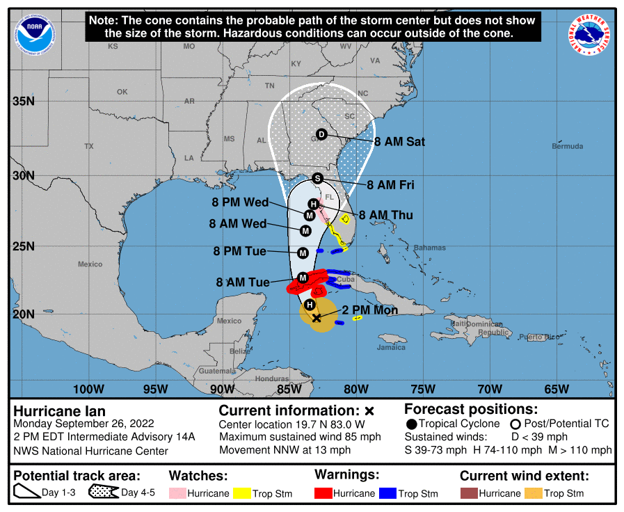
- A hurricane watch is in effect from Englewood to the Anclote River, including Tampa Bay.
- A tropical storm warning is in effect for the lower Florida Keys from Seven Mile Bridge westward to Key West and Dry Tortugas.
- A storm surge watch is in effect for Tampa Bay, Dry Tortugas, Florida Bay, Anclote River southward to the Card Sound Bridge, and the Florida Keys from the Card Sound Bridge westward to Key West.
- The main impact from Ian will be over the Florida Peninsula, not the Panhandle.
- In terms of intensity, Ian is expected to rapidly intensify to major hurricane strength (Category 3 or higher) by tonight and early Tuesday as it moves over the western tip of Cuba. It is forecast to remain a major hurricane in a position just west of Tampa Bay Wednesday night, then weaken as it moves inland Thursday due to strong winds aloft disrupting the core of the hurricane.
- While the hurricane will weaken, it will also begin to move more slowly, and the wind field will expand. There will still be considerable wind and surge impact at the time of landfall along and east of the center.
- One big concern is the slower forward motion that is forecast as the center approaches Tampa Bay, as the upper trough passes north and east of Ian and the steering currents weaken. This would likely prolong the storm surge, wind and rainfall impacts along the affected portions of the west coast of Florida, although the roughly shore-parallel track still makes it difficult to pinpoint exactly what locations will experience the most severe impacts.
- Cities like Tampa, St. Petersburg, Orlando, Fort Myers, Sarasota and Bradenton will experience tropical storm conditions by Wednesday and Thursday. Hurricane conditions are possible along the west coast of Florida where the hurricane watch is in effect.
- Alabama and the central Gulf Coast (Gulf Shores to Panama City Beach) will remain on the dry, offshore flow side of the circulation (the west side with a north wind). The big impact in terms of surge, heavy rain and a tornado threat will be along and east of the circulation center.
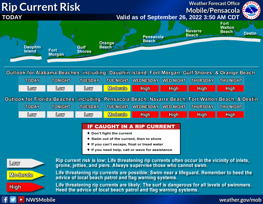
- Even though the hurricane will be well to the east, the surf will be very rough along the central Gulf Coast this week, with high rip-current danger over the latter half of the week. Expect double red flags by Wednesday.
- Regardless of Ian’s exact track and intensity, there is a risk of dangerous storm surge, hurricane-force winds and heavy rainfall along the west coast of Florida by the middle of this week, and residents in the Florida Peninsula should ensure they have their hurricane plan in place. Follow any advice given by local officials and closely monitor updates to the forecast.
ON THIS DATE IN 1898: A school teacher saved 32 children from death in Merritton, Ontario, when she spotted an approaching tornado and led her students to a safe corner. Unfortunately, falling debris killed one child and injured several others.
ON THIS DATE IN 1955: The Atlantic reconnaissance aircraft Snowcloud Five went down while investigating Hurricane Janet and was never heard from again. The commander with a crew of eight and two newspapermen had reported that they were about to begin penetrating the central core of the hurricane.
BEACH FORECAST: Click here to see the AlabamaWx Beach Forecast Center page.
For more weather news and information from James Spann and his team, visit AlabamaWx.


