James Spann: Alabama stays dry through Friday
James Spann forecasts a fine fall day for Alabama from Alabama NewsCenter on Vimeo.
FINE FALL DAY: Temperatures are mostly in the 40s across Alabama early this morning; with a good supply of sunshine, we project a high between 72 and 75 degrees this afternoon, very close to seasonal averages. We stay dry Friday with a partly to mostly sunny sky; the high will be in the mid 70s.
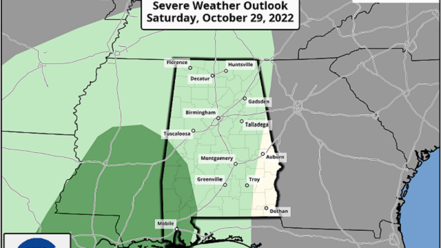
THE ALABAMA WEEKEND: Clouds return to the state late Friday night, and rain will push into west Alabama during the day Saturday. Rain will slowly spread eastward and will be widespread across the state by Saturday night. The Storm Prediction Center has introduced a low-end, marginal risk (level 1 out of 5) of severe thunderstorms for the southwest counties of the state Saturday.
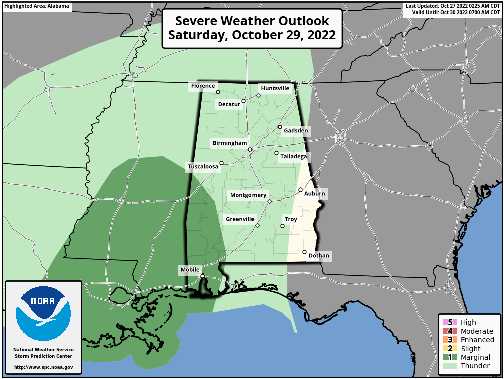 A few storms across southwest Alabama could produce strong, gusty winds, but for the rest of the state there will be little to no surface-based instability, meaning very little thunder. Rain will likely end Sunday morning as a slot of dry air works into the state from the west. A decent part of the state should be dry Sunday afternoon, but some patchy, light rain is possible across north Alabama Sunday night.
Rain amounts over the weekend will be around 1 inch for much of the state. The high will be in the low 70s Saturday, followed by upper 60s Sunday.
NEXT WEEK: The sky will be occasionally cloudy, and some scattered, light rain can’t be ruled out as an upper trough moves through. For now, it looks like most of the state will be dry for trick-or-treaters Monday night. Tuesday is looking dry, but model guidance is now bringing in a wave Wednesday with some risk of rain statewide. Dry air follows Thursday and Friday. Highs through the week will be mostly in the 70s.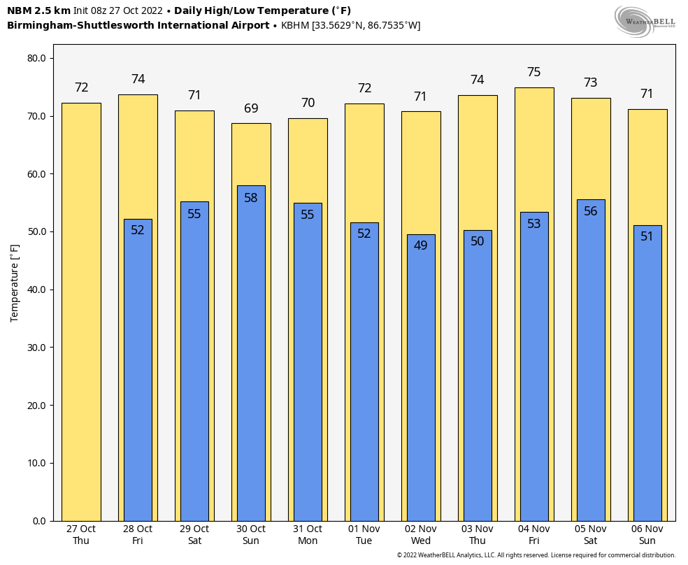 FOOTBALL WEATHER: For Friday night’s high school games across Alabama, the sky will be mostly fair with temperatures falling from the low 70s at kickoff into the 60s by the second half.
Saturday Auburn hosts Arkansas (11 a.m. kickoff) at Jordan-Hare Stadium; the sky will become mostly cloudy during the game, but for now we expect the weather to stay dry. Temperatures will rise from near 68 at kickoff into the low 70s during the second half.
The Magic City Classic (Alabama A&M vs. Alabama State) is Saturday at Birmingham’s Legion Field (2:30 p.m. kickoff). The sky will be mostly cloudy with temperatures hovering around 70 degrees during the first half, falling into the upper 60s by the final whistle. Some light rain can’t be ruled out during the second half.
UAB is at Florida Atlantic in Boca Raton Saturday night (6 p.m. kickoff). The sky will be clear with temperatures falling from near 80 degrees at kickoff into the mid 70s by the final whistle.
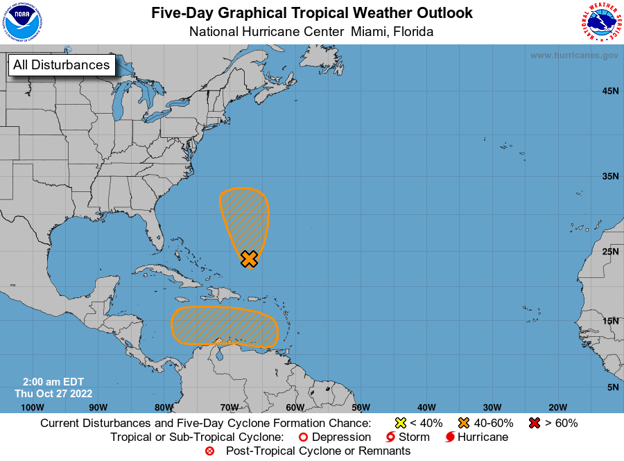
TROPICS: A trough of low pressure stretching from the eastern Caribbean Sea northward to the southwestern Atlantic continues to produce a broad area of disorganized showers and thunderstorms. The northern part of this trough axis is expected to result in the formation of a surface cyclone later today. Environmental conditions then appear marginally conducive for additional subtropical development, and a subtropical depression could form over the next couple of days while the system initially moves northward and then meanders to the west or southwest of Bermuda. By this weekend, upper-level winds are forecast to become less conducive for development. This disturbance will remain well east of the U.S.
An area of low pressure is expected to form over the eastern Caribbean Sea this weekend, possibly related to the southern part of an existing trough of low pressure over the area. Thereafter, environmental conditions are forecast to be conducive for gradual development, and a tropical depression could form by early next week while the disturbance moves generally westward or west-northwestward into the central Caribbean Sea. It’s too early to know whether this will affect any land area.
 ON THIS DATE IN 1940: A late-season heat wave was in progress across the Deep South; Birmingham soared to 88 degrees, which still stands today as the daily record high for Oct. 27.
ON THIS DATE IN 2006: An F1 tornado (waterspout) came ashore and caused significant damage on the west side of Apalachicola, Florida.
BEACH FORECAST: Click here to see the AlabamaWx Beach Forecast Center page.
For more weather news and information from James Spann and his team, visit AlabamaWx.


