James Spann: Record warmth possible in Alabama again today
James Spann forecasts another unseasonably warm day for Alabama from Alabama NewsCenter on Vimeo.
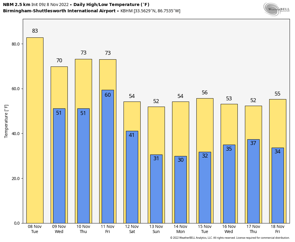
WARM: A strong upper ridge over Alabama will set the stage for another very warm November day. Look for a high between 81 and 85 degrees this afternoon, much like Monday. New record highs could be established again with a partly to mostly sunny sky. An isolated shower or two can’t be ruled out this afternoon, but most places will be dry.
COOLER: A backdoor cold front (moving in from the northeast instead of the northwest) will arrive tonight in dry fashion, and Wednesday will be noticeably cooler. With a sunny sky, the high will be in the low 70s. Thursday will also be dry with a high in the mid 70s.
The far western part of the rain shield associated with Nicole will skirt east Alabama late Thursday night into early Friday morning; the best chance of rain will come from about 10 p.m. Thursday until 6 a.m. Friday, mainly east of I-65. Rain amounts will be light, generally less than one-quarter inch. A north wind will increase to 10-20 mph during the time frame as Nicole passes to the east.
During the day Friday, expect a clearing sky with a high in the upper 60s. A gusty north wind will continue during the day.
COLD: The coldest air so far this season will settle into the Deep South just in time for the weekend. Highs drop into the 50s Saturday and Sunday; some places across the Tennessee Valley won’t get out of the 40s Sunday afternoon. Expect subfreezing temperatures early Sunday morning with a low between 24 and 32 degrees. The air will be dry and the sky will be clear over the weekend.
NEXT WEEK: Temperatures stay below average through the week, with highs in the 50s. The latest global model output suggests there will be some chance of rain in the Wednesday-Thursday time frame with another cold front passing through.
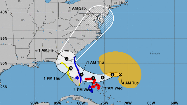
 TROPICS: Subtropical Storm Nicole is about 400 miles east-northeast of the northwestern Bahamas and remains disorganized with winds of 45 mph. But it is expected to make a transition to a tropical storm and begin strengthening later today.
Nicole is expected to make landfall along the Florida coast between Fort Lauderdale and Melbourne late Wednesday night or very early Thursday. A hurricane watch is in effect from Hallandale Beach to the Volusia-Brevard County line, and for Lake Okeechobee.
A dangerous storm surge is expected along much of the east coast of Florida and portions of coastal Georgia, where a storm surge warning is in effect. The storm surge will be accompanied by large and damaging waves. Do not focus on the exact track of Nicole since it is expected to be a large storm with hazards extending well to the north of the center, outside of the forecast cone. These hazards are likely to affect much of the Florida Peninsula and portions of the southeast U.S.
Nicole will produce heavy rainfall Wednesday and Thursday across the Florida Peninsula (not the Panhandle). Flash and urban flooding will be possible across portions of the peninsula along with renewed rises on portions of the St. Johns River. Flash, urban and small stream flooding will be possible in southeast Georgia and portions of South Carolina Thursday into Thursday night.
Some rain is possible over the eastern half of Alabama (along with windy conditions) Thursday night into early Friday morning, but the main impact of Nicole will be to the east over Georgia and the Carolinas.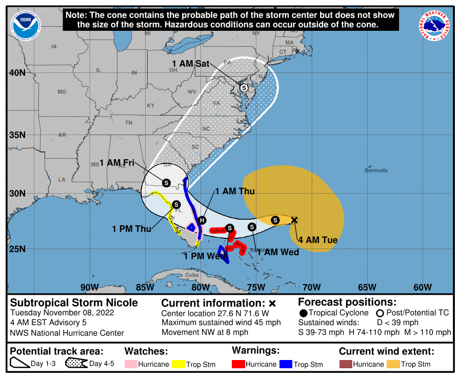 MONDAY’S WARMTH: Record highs across Alabama Monday included 88 at Tuscaloosa, 87 at Montgomery, 86 at Mobile, 85 at Birmingham and 82 at Huntsville.
ON THIS DATE IN 1913: The Great Lakes Storm of Nov. 7-13, 1913, was a blizzard with hurricane-force winds that devastated the Great Lakes region, sinking as many as 19 ships and stranding 19 others. This storm would be the deadliest and most destructive natural disaster ever to hit the Great Lakes.
ON THIS DATE IN 1994: The 12th and final tropical cyclone of the Atlantic hurricane season formed in the southwestern Caribbean. While Hurricane Gordon was only a Category 1, it killed 1,149 people, including 1,122 in Haiti.
BEACH FORECAST: Click here to see the AlabamaWx Beach Forecast Center page.
For more weather news and information from James Spann and his team, visit AlabamaWx.


