James Spann: Strong to severe storms possible in Alabama Tuesday afternoon, evening

James Spann forecasts mild Monday for Alabama, possible severe storms Tuesday from Alabama NewsCenter on Vimeo.
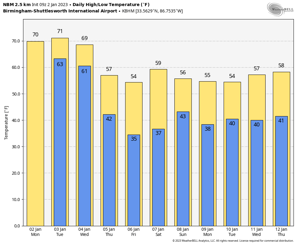
MILD WEATHER CONTINUES: Look for a high between 69 and 74 degrees across most of Alabama today; the average high for Birmingham on Jan. 2 is 54. Dense fog is a problem again this morning over the southern third of the state, where a dense fog advisory is in effect. Scattered showers will form today as moist air surges northward; a thunderstorm is possible in spots this afternoon. But the threat of severe storms will remain to the west through tonight.
TUESDAY: The Storm Prediction Center has defined an enhanced risk (level 3 out of 5) of severe thunderstorms for parts of central and southwest Alabama, in a broad zone from near Tuscaloosa and Birmingham down to Montgomery and just north of Mobile. A slight risk (level 2) covers most of the rest of the state.
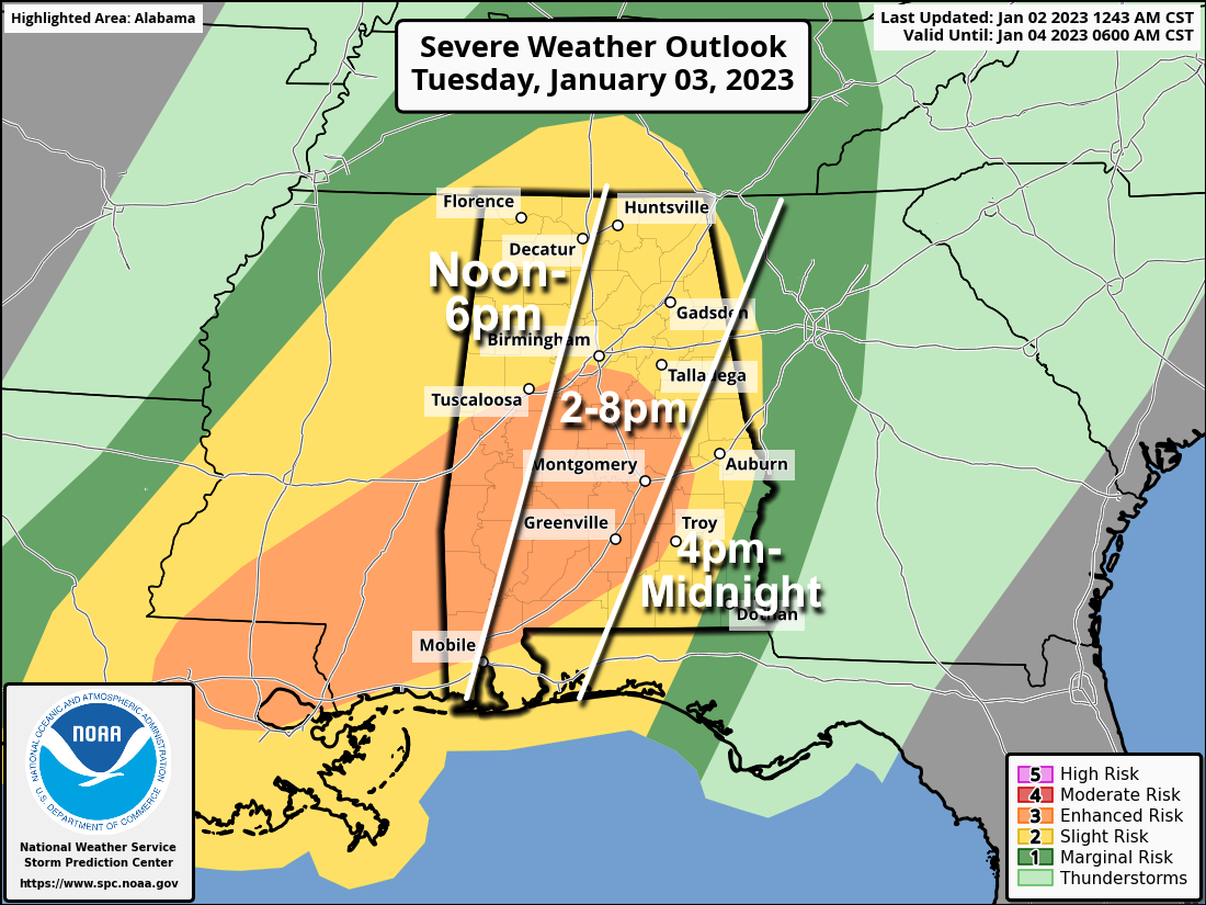 While rain is possible during the morning, the window for strong to severe thunderstorms will open around noon over the western third of the state, with the risk shifting eastward through the afternoon and evening. Thunderstorms that form will be capable of producing strong winds, hail and a few tornadoes. A strong tornado (EF-2 or higher) is possible in the enhanced risk area.
Rain amounts of around 1 inch are likely, with isolated heavier amounts possible. The severe weather threat will fade Tuesday night as the main dynamic support lifts well to the north of Alabama, but rain will remain possible through Wednesday morning.
PREPARE: Be sure you can hear severe weather warnings if they are needed. A NOAA Weather Radio is the baseline, and be sure Wireless Emergency Alerts are enabled on your phone. Install the free ABC 33/40 weather app.
Review your severe weather plan; know the safe place in your home, which is a small room on the lowest floor, near the center of the house, away from windows. If you live in a mobile home, be sure you know the location of the nearest shelter or site-built structure that is available, and the quickest way of getting there.
No need to be anxious; these setups are common in Alabama during our tornado season, which runs from November through May.
REST OF THE WEEK: Rain will end by midday Wednesday, and the weather will be dry and cooler Thursday and Friday with seasonal temperatures (highs in the 50s, lows in the 30s).
THE WEEKEND: Clouds will increase through the day Saturday with a high around 60 degrees. A fast-moving disturbance will bring a chance of showers to the state late Saturday into Sunday morning. There will be no risk of severe storms, and rain amounts should be generally less than one-half inch, not an all-day washout.
NEXT WEEK: Some rain is possible Tuesday; otherwise, much of the week looks dry with highs mostly in the 50s and lows in the 30s — right at average for January in Alabama.
ON THIS DATE IN 1955: Hurricane Alice passed through the Islands of Saint Martin and Saba in the Caribbean Sea. Alice, which developed on Dec. 30, 1954, is the only known Atlantic hurricane to span two calendar years.
ON THIS DATE IN 2017: Thirty-six confirmed tornadoes affected the Deep South from Louisiana to Georgia. There were also numerous wind damage reports, and in Alabama, four people died from straight-line winds when a tree crashed through a mobile home near Rehobeth.
BEACH FORECAST: Click here to see the AlabamaWx Beach Forecast Center page.
For more weather news and information from James Spann and his team, visit AlabamaWx.


