Scott Martin: Wet, breezy start to the Alabama weekend; severe storms possible Thursday
THE WEEKEND: Today will be rainy, cool and breezy across the state as a surface low heads in our direction and eventually moves across southern Alabama later this evening. There may be a couple claps of thunder in the northeastern parts of the state. Highs will be in the lower to mid 50s.
Sunday will start off with rain moving out of the state. In the far northern parts of central Alabama and up into the Tennessee Valley, some snow will be possible mixed in with the rain. However, temperatures will be well above freezing, with early morning lows in the mid 30s to the lower 40s, and afternoon highs in the upper 40s to the upper 50s.
NEXT WEEK: Monday will be a much better day, with sunny skies and warmer temperatures. Highs will be in the 60s.
A low moving northeastward over the Mississippi Valley on Tuesday will pull more moisture and warmer air up from the Gulf of Mexico ahead of an approaching cold front. However, that cold front looks to stall out to our west, and showers will stay out of Alabama until late evening. Highs will be in the mid 60s to the lower 70s.
The air will start to destabilize Wednesday, and showers and thunderstorms will be possible throughout the day. Some of these storms may become strong with hail, but there is no forcing present, so we may have to remove the hail threat in later forecasts. Highs will be in the upper 60s to the upper 70s.
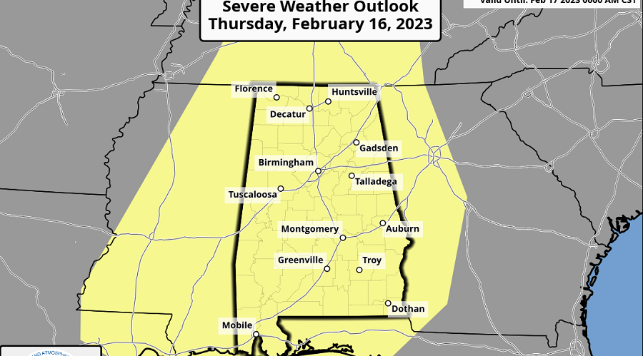
The approaching system starts to move into the state on Thursday, bringing the risk of strong to severe storms. The Storm Prediction Center has all of Alabama in a slight risk for severe storms. Models are showing a good amount of instability, mid-60s dewpoints, shear and a low-level jet in place, which means there will be the threat of tornadoes, damaging winds and large hail. We’ll get a better idea on timing and locations in future updates, especially when the higher-resolution models come into play. Highs will be in the upper 60s to the upper 70s.
On Friday rain will be exiting the state through the early morning, and much cooler air will begin moving in. Skies will eventually become mostly sunny, and highs will be only in the mid 40s to the mid 50s.
For more weather news and information from James Spann, Scott Martin and other members of the James Spann team, visit AlabamaWx.


