James Spann: Severe storms move into north Alabama tonight
QUIET AFTERNOON: We have a generally cloudy afternoon across Alabama with a few sprinkles on radar; temperatures are in the 70s. The focus is on the severe weather threat tonight; to the west the Storm Prediction Center has issued a rare high risk (level 5 out of 5) of severe thunderstorms around Memphis and into eastern Arkansas. A significant tornado moved through north Little Rock, Arkansas, at mid-afternoon, and a few strong, violent tornadoes could touch down northwest of Alabama through the evening.
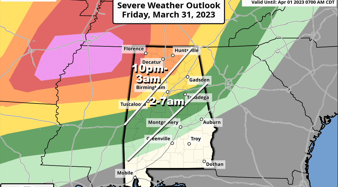
TONIGHT: There is a moderate risk (level 4 out of 5) of severe thunderstorms for the northwest corner of the state tonight, around the Shoals. An enhanced risk (level 3) extends to Scottsboro, Cullman, Jasper and Reform. A slight risk (level 2) has been defined down to Anniston, Hoover and Moundville, and a marginal risk (level 1) is in effect down to Alexander City, Prattville and Thomasville.
The window for severe thunderstorms will begin around 10-11 p.m. across northwest Alabama, with the risk extending southeastward through the night. The highest tornado threat is in the level 3 and 4 risk areas north and west of Birmingham tonight. A few strong tornadoes (EF-2 or higher) are possible.
The greatest threat will shift to strong straight-line winds after 2 a.m. as the line drops southward, but an isolated tornado can’t be ruled out.
Non-thunderstorm gradient winds could gust to 40 mph in spots tonight; a wind advisory is in effect for the northern half of the state.
With events like this it is very important that you have a way of hearing weather warnings in the middle of the night. The baseline for every home and business is a NOAA Weather Radio. Those will wake you up. Never, ever rely on an outdoor siren. Be sure your phone has Wireless Emergency Alerts enabled, and “Do Not Disturb” and “Sleep Mode” are not active. Know the safe place in your home and have helmets for everyone in the family there.
If you live in a mobile home, know the location of the nearest shelter (or business that is open 24/7 that can serve as a shelter), and the fastest way of getting there. Have transportation available. It sure isn’t convenient going to a shelter during the hours before dawn, but you can’t risk your life staying in a mobile home if you are in a tornado warning polygon.
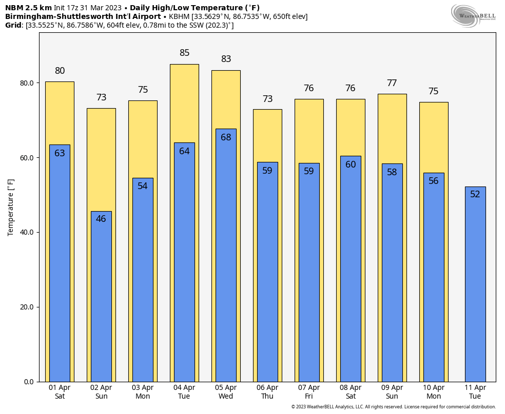
The weakening line of storms will shift into south Alabama Saturday morning and should be out of the state by early afternoon. Severe storms are not expected across south Alabama Saturday. For north and central Alabama, Saturday will be dry after the lingering early-morning showers with a mostly sunny sky and a high between 75 and 80 degrees.
Sunday will be a nice day; with a sunny sky the high will be in the low to mid 70s.
NEXT WEEK: At this point it looks like there will be some risk of rain daily. Strong storms are possible late Tuesday night into Wednesday as a cold front settles into the state, but it is too early to know whether we have a meaningful severe weather threat. The front becomes stationary, meaning showers and storms will remain possible Thursday and Friday. Highs through the week will be in the 70s and 80s.
 ON THIS DATE IN 1962: A tornado struck the town of Milton, Florida, killing 17 people and injuring 100 others. It was the worst tornado disaster in Florida history.
ON THIS DATE IN 1973: A devastating long-track F3 tornado took a nearly continuous 75-mile path through north-central Georgia, causing more than $104 million damage. The tornado first touched down near Jonesboro around 5:30 p.m. and carved a path through Clayton, Henry, Dekalb, Rockdale, Walton, Oconee, Clarke and Oglethorpe counties before finally dissipating 10 miles east-northeast of Athens. Two were killed, one near Conyers and one in Athens.
ON THIS DATE IN 2020: A tornado moved through the southern part of Eufaula. The most significant damage occurred in the Country Club of Alabama neighborhood along the south side of Pebble Beach Drive. Large sections of roofs were removed from a few well-built residences with collapse of some exterior walls. The tornado crossed the Walter F. George Reservoir along the Chattahoochee River and continued into Quitman County in Georgia.
BEACH FORECAST: Click here to see the AlabamaWx Beach Forecast Center page.
For more weather news and information from James Spann and his team, visit AlabamaWx.


