James Spann: Hottest week of the summer for Alabama
James Spann says temperatures will approach 100 degrees in Alabama this week from Alabama News Center on Vimeo.
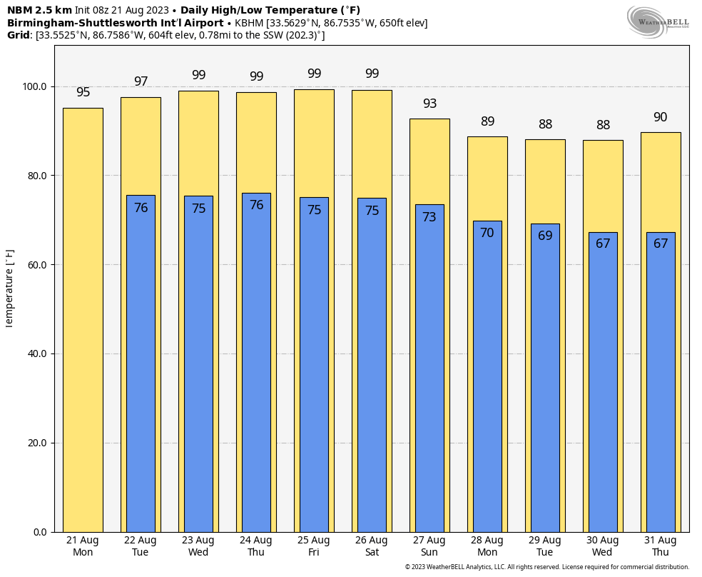
HOT: A strong upper high covers much of the eastern two-thirds of the U.S. this morning and will set the stage for the hottest week of the summer for the Deep South. With a sunny sky, we project a high today between 95 and 99 degrees for most places. Highs for the rest of the week will be fairly close to 100 degrees with mostly sunny days and fair nights. Higher heat levels will be found over the western and southern counties of the state. An isolated storm could pop up somewhere across south Alabama on a day or two, but most of the state will stay dry through the week.
The weather is always hot in August around here, and I don’t share “heat tips”; Alabamians know to drink lots of water, stay out of the sun during the hottest part of the day and go into an air-conditioned room. It isn’t brain surgery. But heat exhaustion and heat stroke are very real, so if you work outdoors be aware of the symptoms — throbbing headache; confusion; nausea; dizziness; body temperature above 103 degrees; hot, red, dry or damp skin; and a rapid, strong pulse.
THE WEEKEND: The weather won’t change much Saturday with a high between 97 and 101 degrees, but heat levels drop Sunday as the upper ridge weakens and shifts to the west. Sunday’s high will be in the low 90s, and a few afternoon showers or storms could pop up thanks to the cooler air aloft.
NEXT WEEK: Highs drop into the upper 80s through the first half of the week, and we will mention a chance of scattered showers and storms daily. The high will be at or just over 90 Thursday and Friday with only isolated storms.
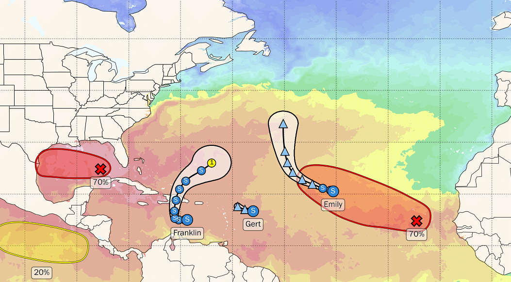
 TROPICS: We have a trio of tropical storms in the Atlantic this morning:
- Gert is a junk system about 450 miles east/southeast of the northern Leeward Islands with winds of 40 mph. It will fizzle later today far from land.
- Emily is another junk storm with winds of only 40 mph. It is 1,100 miles west of the Cabo Verde Islands and will become post tropical later today with no impact to any land mass.
- Franklin is packing sustained winds of 50 mph and is about 240 miles south of Santa Domingo, Dominican Republic, in the Caribbean. This will bring heavy rain to parts of Hispaniola and Puerto Rico through Tuesday. It will ultimately turn northeast in the Atlantic and will remain well east of the contiguous U.S.
Closer to home, showers and thunderstorms continue in association with a trough of low pressure (Invest 91L) in the eastern Gulf of Mexico. Environmental conditions appear favorable for development of this system while it moves westward at about 15 to 20 mph across the central Gulf of Mexico. A tropical depression or storm is likely to form while it approaches the coast of south Texas Tuesday. Tropical storm watches or warnings may be necessary later today for portions of the southern Texas and northern Mexico coastlines.
This feature will remain well to the south of Alabama and the central Gulf Coast, but it will bring a high rip current danger today and Tuesday.
ON THIS DATE IN 1883: An estimated F5 tornado caused extensive damage to Rochester, Minnesota. The enormous roar was said to have warned most Rochester residents as the massive funnel cut through the north side of town. More than 135 homes were destroyed and another 200 damaged. Many of the 200-plus injuries were severe, and at least 37 people were killed, but probably more. This tornado eventually led to the formation of the Mayo Clinic.
For more weather news and information from James Spann and his team, visit AlabamaWx.


