James Spann: Strong to severe storms possible in Alabama Tuesday afternoon, night
CLOUDY, DRY AFTERNOON: Temperatures are between 77 and 81 degrees across most of Alabama this afternoon with a mostly cloudy sky. There’s nothing on radar, and our weather should remain dry tonight. Then, a dynamic system will bring active weather to the Deep South Tuesday afternoon and night.
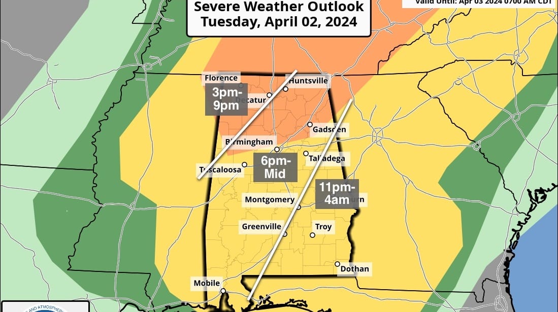
The Storm Prediction Center has defined an enhanced risk (level 3 out of 5) of severe thunderstorms for areas north of a line from Vernon to Birmingham to Piedmont; a slight risk (level 2) is now up for the rest of the state.
The primary window for strong to severe thunderstorms will come from around 3 p.m. Tuesday through 2 a.m. Wednesday. The main threat for Alabama will come from strong, potentially damaging straight-line winds. The main parameters needed for tornadoes will be to the north (a level 4-5 risk is up for much of Ohio), although an isolated tornado or two can’t be ruled out across north Alabama. Some hail is possible as well.
Rain amounts will be one-half to 1 inch for the northern half of Alabama, and less than one-half inch for the southern counties.
Wednesday will be breezy and much cooler, with lingering clouds and highs between 57 and 64 degrees over north Alabama. South Alabama will see lots of sun with a high in the 60s. Thursday and Friday will be sunny and cool statewide, with a high in the 60s.
FROST/FREEZE THREAT: We have frost potential over the northern two-thirds of Alabama Friday morning and possibly Saturday morning. Colder spots could see a freeze. Growers will need to monitor temperature forecasts.
THE WEEKEND: Dry weather continues over the weekend with lots of sun and highs in the 70s. New model data suggests showers are possible Monday, followed by a more significant system by midweek.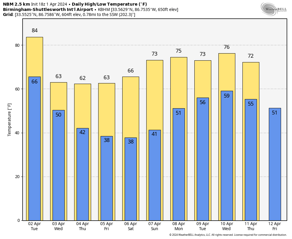 ECLIPSE WEATHER: Alabama will experience a partial solar eclipse one week from today, April 8. For now, we are forecasting a partly sunny sky.
ON THIS DATE IN 1960: The first weather satellite, TIROS 1 (Television and Infra-Red Observation Satellite) began sending pictures back to Earth. The TIROS series would have little benefit to operational weather forecasters because the image quality was low and inconsistent. The most critical understanding achieved from the new technology was the discovery of the high degree of organization of large-scale weather systems, a fact never apparent from ground and aircraft observations.
ON THIS DATE IN 2023: An EF-3 tornado moved through northern Madison County near Hazel Green; one person was killed. An EF-1 tornado moved through parts of Marion and Winston counties.
For more weather news and information from James Spann and his team, visit AlabamaWx.


