James Spann: Strong to severe storms remain possible for Alabama through tonight
RADAR CHECK: At midafternoon, showers and a few thunderstorms continue across the northwest corner of Alabama. The rest of the state is mostly cloudy and warm, with temperatures between 77 and 81 degrees.
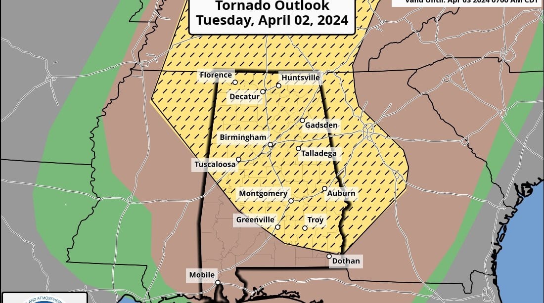
The Storm Prediction Center has expanded the enhanced risk (level 3 out of 5) of severe thunderstorms to include much of Alabama, with the exception of the southwest counties, where a slight risk (level 2) is in place.
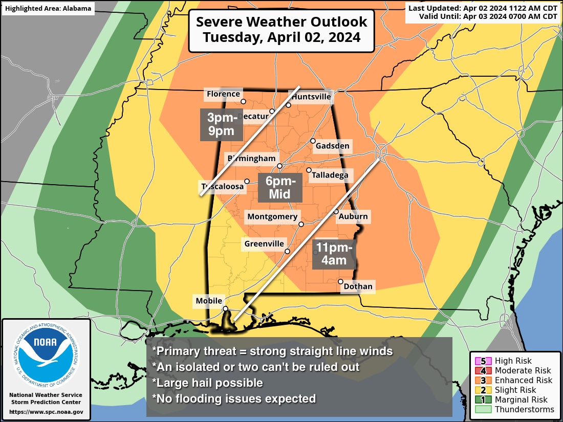
A messy mass of convection will move across Alabama through tonight. The primary surface low and dynamic forcing are well to the north of Alabama, but models are hinting at an increasing low-level jet during the evening and nighttime, which could bring potential for a tornado or two. The highest tornado threat has actually shifted into the southern two-thirds of the state, but even there this is a conditional threat as it remains to be seen whether winds can align for rotating thunderstorm updrafts.
The main concern tonight is from strong thunderstorm winds and hail.
As always, have a reliable way of getting warnings, and have a good severe weather action plan. A few warnings could be needed for southeast Alabama after midnight, one reason we prefer people to have a NOAA Weather Radio as their primary source.
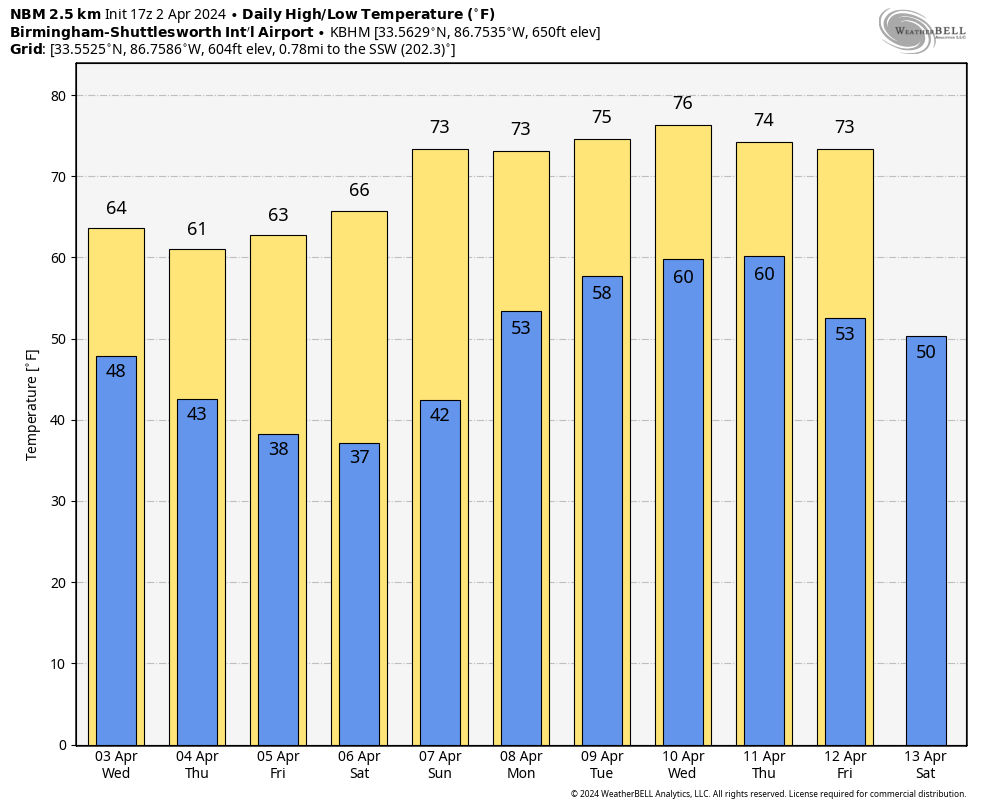
REST OF THE WEEK: Wednesday will be breezy and much cooler, with highs in the 60s. Clouds will likely linger much of the day over the northern counties, with lots of sun for the southern part of Alabama. Dry weather continues Thursday and Friday with a good supply of sunshine both days.
FROST/FREEZE POTENTIAL: Lows will drop into the 30s for much of the state Friday and Saturday mornings, with a good chance of frost. Colder spots will have the potential for freezing temperatures. Growers will need to keep a close eye on temperature forecasts. On the positive side, there is a good chance this will be the last frost/freeze threat this season for most places.
THE ALABAMA WEEKEND: Sunny weather continues over the weekend; the high will be in the 60s Saturday, followed by low to mid 70s Sunday.
NEXT WEEK: The weather looks unsettled for much of the week with some chance of rain daily. Stronger storms will be possible by midweek.
 ON THIS DATE IN 1957: An F3 tornado tore through Dallas. Ten people were killed and 216 were injured. Total damage was $1.5 million. This tornado was among the most photographed and studied in history.
ON THIS DATE IN 1982: Severe thunderstorms spawned 56 tornadoes in the central U.S., including 17 in the Red River Region of Texas and Oklahoma. The tornadoes claimed 30 lives and injured 383 other people. A violent tornado near Messer, Oklahoma, left only the carpet tack strips on the slab of a house it destroyed and carried a motel sign 30 miles.
For more weather news and information from James Spann and his team, visit AlabamaWx.


