Bill Murray: Beautiful Saturday for Alabama
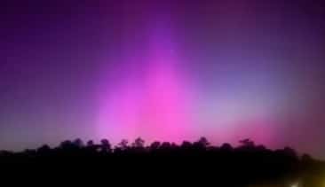
DID YOU SEE THE AURORA? Everyone was going bonkers last night with the beautiful pinks and magentas of the Aurora Borealis dancing in the Alabama sky. A G5 geomagnetic storm struck Earth overnight, producing magnificent auroras as far south as Texas and Florida, including many locations in Alabama, including the Birmingham metro area.
NICE SATURDAY: Like Friday, today’s weather will be almost perfect, with a good supply of sunshine and high temperatures in the upper 70s. Winds will be light, out of the north and northwest. Dewpoints in the lower 50s will keep the air from feeling humid.
A weak, trailing cold front will bring a few clouds our way today, but they won’t block the sun. There could be a few light showers in Tennessee, and a couple of them could veer into the Tennessee Valley of north Alabama, especially after 8 p.m. tonight.
MOTHER’S DAY FORECAST: Clouds will thicken during the day Sunday, and showers and thunderstorms will be approaching from the west. After a nice start in the middle and upper 50s, afternoon readings will climb into the 80s. Showers will reach western Alabama after midnight.
MONDAY/TUESDAY: Showers will continue to increase as we head into Monday morning. An upper low over Kansas and Missouri and a surface low over Kansas will lift a warm front northeastward across Alabama. We probably will see a couple of rounds of rain. As the low tracks to the north of us, the showers will linger into Tuesday. Highs will be in the 70s. There could be a little thunder late Monday night and before dawn Tuesday, but no severe weather is expected. South Alabama will experience heavy rains. For north and central Alabama, amounts should average less than an inch. A cold front will sweep through Tuesday night, putting an end to the rain.
MID TO LATE WEEK: Skies on Wednesday will be partly cloudy, becoming mostly sunny as we go through the day. Highs will be around 80 degrees. On Thursday, skies will become cloudier as we go through the day. A few showers will move into south Alabama late in the day. Showers and thunderstorms will become likely Thursday night. There are some signs that severe weather may be in the picture after midnight over parts of the state. Showers will linger into Friday. Rainfall amounts will be fairly generous, reaching 2 inches in spots across north and central Alabama. A second round of storms will bring heavy rainfall to south Alabama.
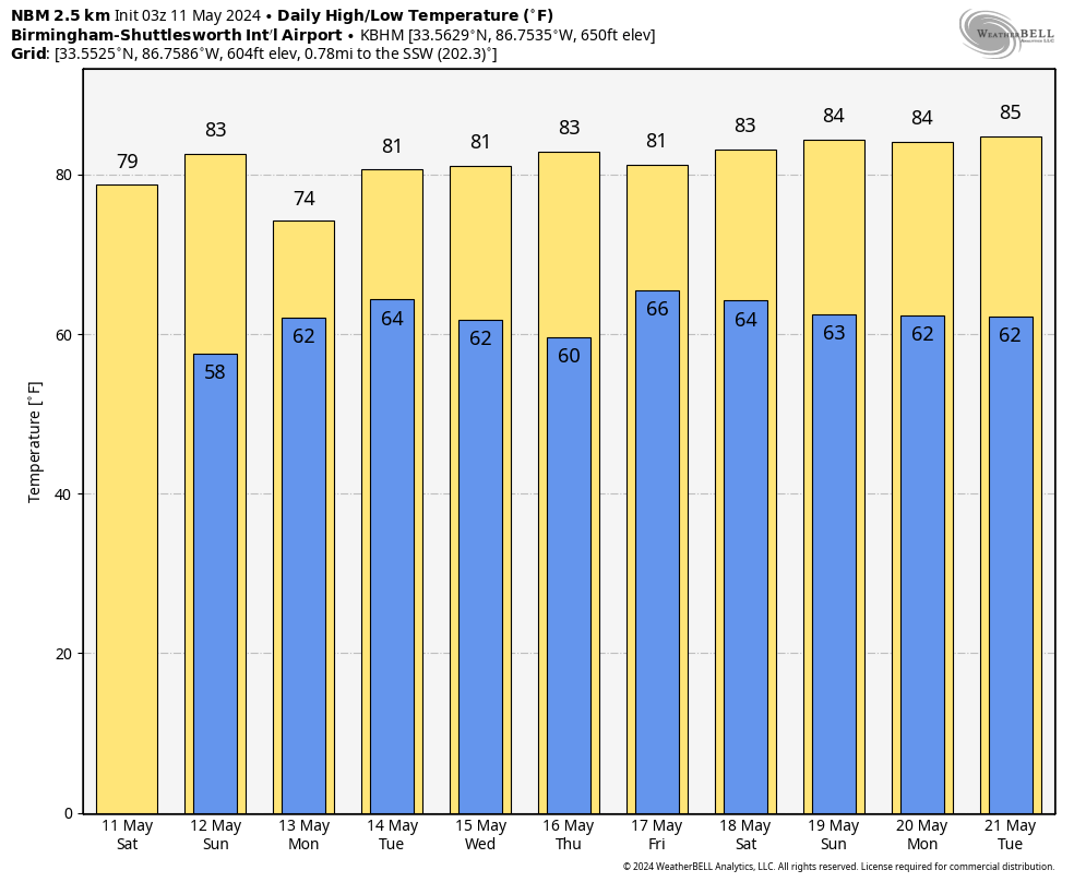
NEXT WEEKEND: An upper low will keep a few showers in the forecast into Saturday and Sunday. Highs will be in the 80s, lows in the 60s. Rainfall amounts will be light, generally less than one-quarter inch. The unsettled weather will continue into the following week.
TROPICS: We should see our first eastern Pacific hurricane of the season by late in the week. A depression is forecast to form off the southwestern coast of Mexico. In weak steering currents, it won’t travel very far, becoming a tropical storm by Thursday and a hurricane by Friday before making landfall Saturday night near Puerto Angel on the Mexican coast.
ON THIS DATE IN 1953, 1970: Two of the most infamous tornadoes in United States history occurred on May 11. The 1953 Waco tornado is the deadliest in Texas history, with 114 fatalities. The 1970 Lubbock, Texas, tornado (actually two of them) destroyed one-quarter of the city and killed 28 people.
For more weather news and information from James Spann, Bill Murray and other members of the James Spann team, visit AlabamaWx.


