Scott Martin: A few strong storms possible in Alabama today, Saturday
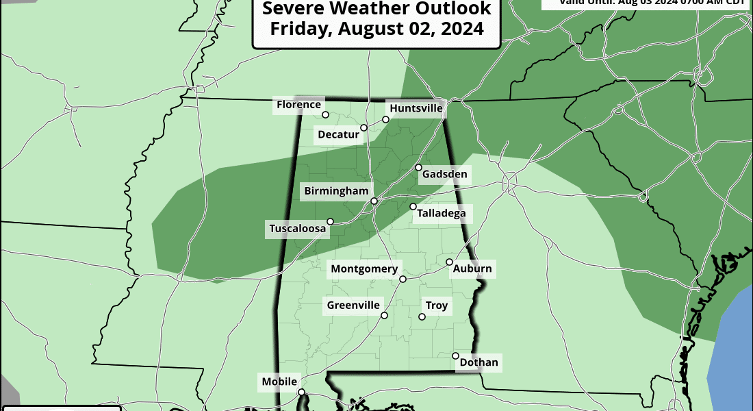
TODAY: While there will not be much change in the heat and humidity today, we will see an increase in rain chances as a front approaches Alabama. Isolated to scattered showers will be possible starting in the afternoon, with the higher chances over the northern locations. A few storms may be strong to severe, and the Storm Prediction Center has a marginal risk up for the I-59 corridor, reaching as far north as Haleyville to just east of Huntsville, and as far south as Livingston to Calera to Oxford. Highs will be in the 90s.
THE WEEKEND: Scattered showers and storms will continue to be possible, with the higher concentration over southern Alabama, where the front is expected to stall out. A few strong storms are possible, mainly over east-central Alabama. Highs will be a little lower, reaching the upper 80s to the mid 90s. We may actually be dry on Sunday, as it now looks that a developing tropical system will be moving roughly northward over the Florida Peninsula. That will keep us dry and allow the heat to crank back up into the lower to mid 90s.
NEXT WEEK: Weather will be sunny, hot and dry on Monday as the tropical system pulls most of the moisture with it. Highs will reach the 90s. We’ll stay hot and dry on Tuesday as the system continues to move farther away from us and back over the Atlantic Ocean. Highs will be in the lower to mid 90s. Heat increases Wednesday from the west as we continue to stay dry. On Thursday, while Alabama remains dry, the tropical system tries to make its way back onshore in southeastern North Carolina. Highs will be in the lower to mid 90s.
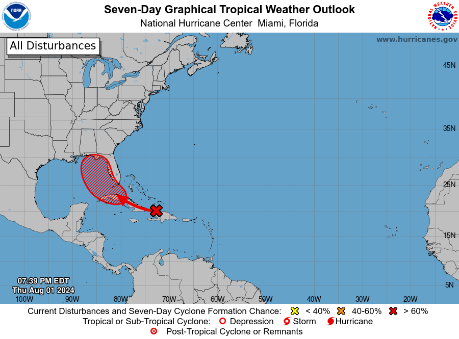
TROPICS: A tropical wave in the Straits of Florida and eastern Gulf of Mexico could become a tropical depression over the weekend. This system is producing disorganized showers and thunderstorms and is expected to move west-northwestward, potentially affecting Cuba and the southeastern Bahamas. The system could develop into a tropical depression by Saturday as it moves into the Straits of Florida or eastern Gulf of Mexico; heavy rains could lead to flash flooding in Florida, Cuba and the Bahamas. A NOAA Hurricane Hunter aircraft may investigate the system today if needed. Formation chances are 40% over the next 48 hours and 70% over the next seven days.
ON THIS DATE IN 1989: Low pressure representing the remains of Hurricane Chantal deluged north-central Texas with heavy rain. Up to 6.5 inches drenched Stephens County, and Wichita Falls reported 2.22 inches of rain in just one hour. Bismarck, North Dakota, reported a record warm morning low of 75 degrees and record hot afternoon high of 101 degrees, and evening thunderstorms in North Dakota produced wind gusts to 78 mph at Lakota. Early evening thunderstorms produced high winds that downed trees at the town of Christmas, Florida.
For more weather news and information from James Spann, Scott Martin and other members of the James Spann team, visit AlabamaWx.


