James Spann: Much drier week ahead for Alabama

RADAR CHECK: We note a few showers and thunderstorms over southwest Alabama this morning, but the rest of the state is dry with temperatures mostly between 70 and 75 degrees. We expect a partly sunny sky today, and showers will be mainly confined to the southern half of the state. Highs will be in the low to mid 80s this afternoon.
Most of Alabama will be dry Tuesday through Friday, although we will continue to mention a chance of showers for the southern counties Tuesday and Wednesday. Highs will be in the 80s, lows mostly in the 60s.
THE ALABAMA WEEKEND: At this point we see a totally dry weekend for Alabama with mostly sunny, warm days and fair, pleasant nights. Highs hold in the 80s, with lows in the 60s.
Much of next week is looking rain-free as well, with highs in the 80s.
 TROPICS: Potential Tropical Cyclone 8 is about 95 miles east/southeast of Charleston early this morning with sustained winds of 50 mph. While it is not a true tropical cyclone (more of a hybrid), a tropical storm warning is in effect from Edisto Beach, South Carolina, to Ocracoke Inlet, North Carolina. This low will move inland this afternoon and will bring lots of rain to parts of the Carolinas.
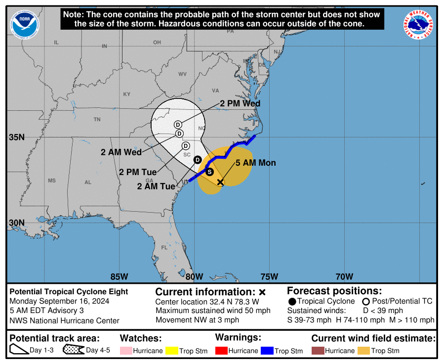
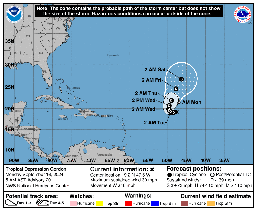
In the middle of the Atlantic, Tropical Depression Gordon is still hanging on but could dissipate soon. If the system can survive, it will turn north into the open Atlantic and will remain far from land.
 The rest of the Atlantic basin is very quiet.
ON THIS DATE IN 2004: At 51 minutes after midnight, the northern eyewall of powerful Hurricane Ivan moved onto land near Gulf Shores as an upper-end Category 3 hurricane, bringing with it 130 mph surface winds and a 12-foot storm surge.
Estimates show that the magnitude and extent of the damage and destruction over Baldwin County and over Escambia and Santa Rosa counties of northwest Florida likely exceeded that of both Hurricane Frederic (September 1979) and Hurricane Opal (October 1995). Hurricane Ivan was very close to the magnitude of damage and destruction caused by the Hurricane of 1926, which ravaged the aforementioned counties east of Mobile Bay.
Ivan produced estimated maximum winds of 60 to 80 mph generally southwest of a line from Prattville to Livingston. A few spots may have reached 90 mph in this area. Most other locations across central Alabama had estimated maximum wind speeds of 50 to 60 mph, with a few isolated spots reaching 75 mph. Damage was severe well inland; some of the hardest-hit communities were Atmore, Brewton, Evergreen, Monroeville, Camden and Demopolis.
Ivan caused $18.82 billion of damages in Alabama, the costliest ever recorded in the state. However, despite 56 people dying in the United States, none of them were in Alabama. It was the last storm to make landfall in Alabama until Hurricane Sally. Hurricane Ivan was also the strongest hurricane to hit Alabama since Hurricane Frederic in 1979, which was Category 4.
For more weather news and information from James Spann and his team, visit AlabamaWx.


