James Spann: Warm, mostly dry weather for Alabama through Wednesday
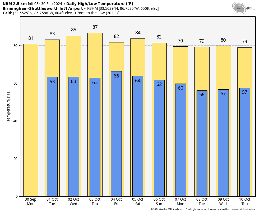
FOGGY START: We have a dense fog advisory for the northern half of Alabama early this morning; the fog will dissipate by midmorning. Today will be warm with a partly sunny sky; again, we have the chance of a few isolated showers over the northern third of the state this afternoon. The chance of any one spot seeing rain is only 15-20%, and the high will be in the low to mid 80s.
Tuesday will be dry and warm with only a small risk of a shower over north Alabama. Wednesday will be dry statewide with highs in the mid 80s.
Moisture levels begin to rise Thursday, and we will mention a chance of showers over the southern half of the state. Showers are possible statewide on Friday, but it won’t be a washout. Highs will be mostly in the low 80s on these two days.
THE ALABAMA WEEKEND: At this point the weekend looks warm and dry. Expect a partly to mostly sunny sky Saturday and Sunday with highs between 81 and 84 degrees.
For now, much of next week looks dry and cooler, with highs dropping into the upper 70s and lows in the 50s.
TROPICS: Joyce is a weak tropical depression in the middle of the Atlantic far from land; it dissipates later today.
Tropical Storm Isaac is in the North Atlantic. It will become post-tropical by tonight in the colder water and is no threat to land.
Tropical Depression 12 is in the eastern Atlantic and is forecast to become a major hurricane by the end of the week. But it will turn north into the open Atlantic and is no threat to land.
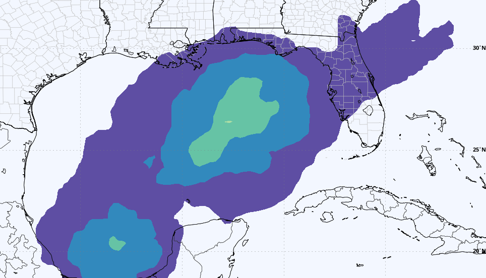
A broad area of low pressure over the western Caribbean Sea is producing disorganized showers and thunderstorms. Environmental conditions appear to be conducive for gradual development, and a tropical depression could form around the middle of this week while the disturbance moves slowly west-northwestward. This system is then expected to move into the Gulf of Mexico during the latter portion of this week. Interests in the northwestern Caribbean Sea and along the U.S. Gulf Coast should monitor its progress.
The National Hurricane Center gives it a 50% chance of development, and it is still too early to know the final destination or intensity. Most global models push the tropical low into the Florida Peninsula (not the panhandle) in a week or so, but we don’t know how it plays out at this point.
RACE WEEKEND: A few showers are possible across east Alabama Saturday, but for now the weekend looks warm and dry for the races at the Talladega Superspeedway. Afternoon temperatures will be in the low to mid 80s; lows will be in the 60s.
ON THIS DATE IN 1896: A hurricane that formed on Sept. 22 lasted until Sept. 30. It formed directly over the Lesser Antilles and hit Cuba, Florida, Georgia, South and North Carolina, Virginia, Washington, D.C., and Pennsylvania. Its maximum sustained winds were at 130 mph.
For more weather news and information from James Spann and his team, visit AlabamaWx.


