James Spann: Needed rain moves into northwest Alabama tonight

RAIN GETTING CLOSER: Alabama is dry early this morning, but we are watching a band of rain and a few thunderstorms from near Dallas to St. Louis to Chicago ahead of a surface front. These showers will likely move into the northwest corner of the state late this afternoon or early tonight, then progress slowly to the Southeast through Friday.
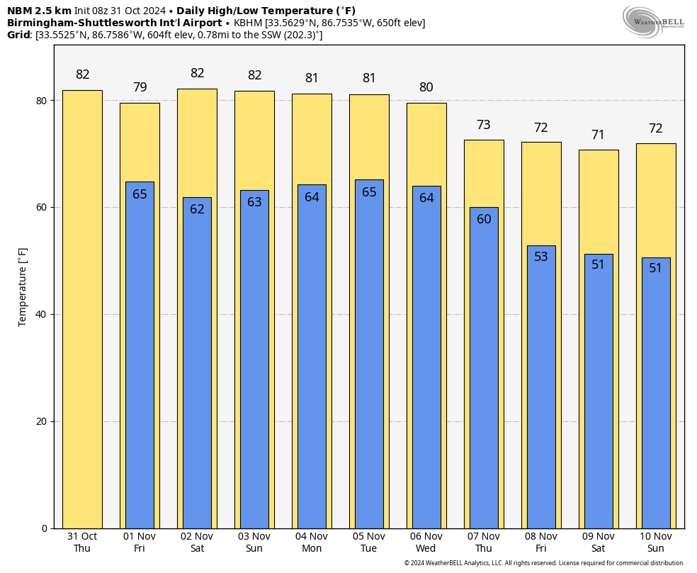
The most significant rain will come across northwest Alabama from the Shoals down to places like Russellville and Hamilton, where one-half to 1 inch is expected. Amounts will be much lighter near I-59 (Tuscaloosa, Birmingham, Gadsden), and little, if any, rain is expected over the southern two-thirds of the state.
Any lingering showers should end late Friday afternoon, and the weather looks dry across Alabama Friday night through the weekend with warm days and pleasant nights. Highs will be in the low 80s Saturday and Sunday, with lows in the 60s.
NEXT WEEK: Forecast confidence is not especially high with inconsistent output from global models, but parts of the state could see some chance of rain by midweek ahead of another surface front. If rain does fall, amounts most likely will be light; highs will be around 80 Monday through Wednesday, falling into the low 70s by Thursday and Friday.
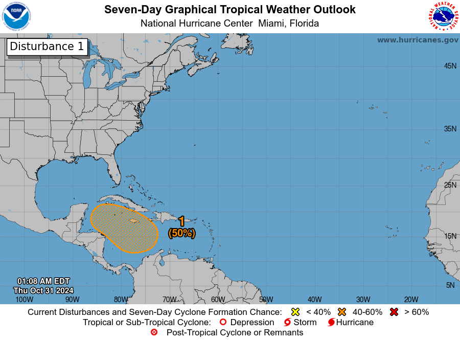
TROPICS: A broad area of low pressure is likely to develop over the southwestern Caribbean Sea by the end of the week. Gradual development is possible thereafter, and a tropical depression could form over the weekend or early next week while the system drifts generally northward or northwestward over the central or western Caribbean Sea.
The National Hurricane Center gives it a 50% chance of development over the next seven days; most global models continue to show a weak tropical low meandering around the northern Caribbean or southern Gulf of Mexico.
FOOTBALL WEATHER: For the high school games Friday night, most stadiums across Alabama will be dry with temperatures falling through the 70s, reaching the 60s by the fourth quarter.
Saturday, Auburn hosts Vanderbilt at Jordan-Hare Stadium (11:45 a.m. kickoff). Expect a good supply of sunshine with temperatures rising from near 78 at kickoff into the low 80s by the second half.
UAB will host Tulsa at Protective Stadium in downtown Birmingham (1:30 p.m. kickoff). The sky will be partly to mostly sunny with temperatures hovering around 80 degrees during the game.
Troy will host Coastal Carolina (3 p.m. kickoff); it will be mostly sunny with temperatures falling from near 82 at kickoff into the 70s by the fourth quarter.
ON THIS DATE IN 1991: A severe winter storm, dubbed the Great Halloween Mega Storm, struck the upper Midwest. Minnesota bore the brunt of this storm. Blizzard conditions occurred with winds gusting frequently to 40 and 50 mph. By the time it was all over on Nov. 2, Duluth recorded 37 inches, Minneapolis 28 inches, International Falls 18 inches and Sioux Falls, South Dakota, 11.2 inches in 24 hours, its earliest snowfall of 6 inches or more and snowiest October on record. For Duluth and Minneapolis, the snow amounts set new all-time records for a single storm.
For more weather news and information from James Spann and his team, visit AlabamaWx.


