James Spann: Most of Alabama stays dry today; southwest corner still wet

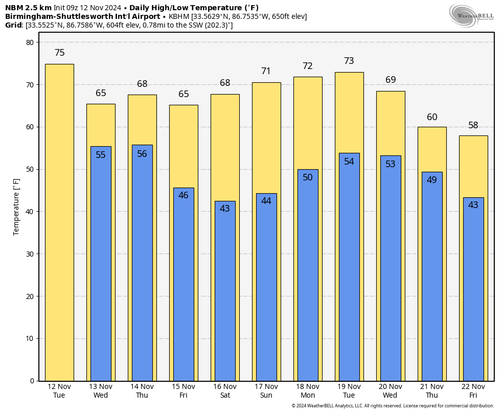
RADAR CHECK: Rain is still falling this morning over Mobile and Baldwin counties, but the rest of the state is dry. Cooler spots are in the 40s over north Alabama, where the sky is clear. Today will be partly to mostly sunny for north and central Alabama, but clouds will linger over the southern counties, with showers for the southwest corner. Highs will be mostly in the 70s.
Clouds increase statewide Wednesday ahead of an upper trough, and periods of rain are likely late Wednesday into Thursday, mainly during the morning. Rain amounts could exceed 1 inch for the northern third of the state (north of I-59). For places like Birmingham, Tuscaloosa, Anniston and Gadsden, amounts will be one-half to 1 inch. Totals for south Alabama will be lower, generally less than one-half inch. Highs will be mostly in the 60s Wednesday and Thursday.
The Storm Prediction Center has defined a marginal risk of severe thunderstorms for the southwest corner of Alabama late Wednesday and Wednesday night; heavier storms there could produce strong, gusty winds. A brief, isolated tornado can’t be ruled out.
FRIDAY AND THE WEEKEND: Nights will be noticeably cooler, with lows mostly in the 40s, but some of the colder spots across north Alabama will reach the mid to upper 30s early Saturday morning. Look for sunny, pleasant days with highs in the 60s Friday and between 67 and 73 degrees over the weekend.
NEXT WEEK: The weather stays dry for the first half of the week, but a dynamic weather system will bring some risk of rain and possible thunderstorms to the Deep South by Thursday night and Friday. It’s way too early to know whether severe storms or heavy rain will be involved.
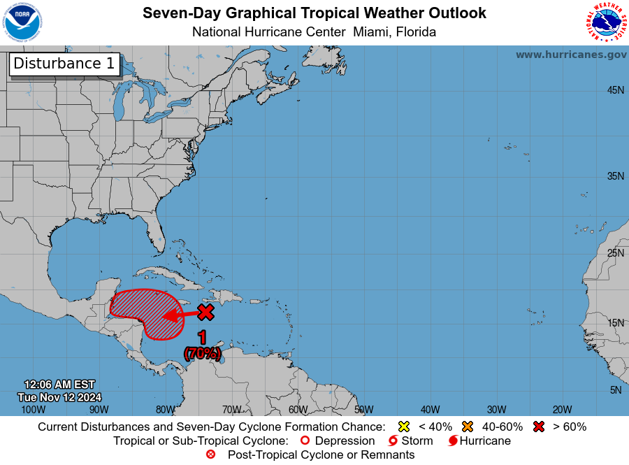
TROPICS: A tropical wave over the central Caribbean Sea is producing an area of disorganized showers and thunderstorms. Environmental conditions appear conducive for development, and a tropical depression is likely to form by the end of the week as the system moves slowly westward into the western Caribbean Sea. Afterward, the disturbance is expected to meander over the western Caribbean Sea through the weekend and begin moving slowly, generally northwestward, by early next week.
The National Hurricane Center gives it a 70% chance of developing; if the system becomes a tropical storm, the name will be Sara. Many of the global model ensemble members suggest it could enter the far southern Gulf of Mexico before turning northeast, meaning some possible impact for south Florida in seven to 10 days, but of course it is way too early to know the track or intensity.
ON THIS DATE IN 1970: The deadliest tropical cyclone ever recorded and one of the deadliest natural disasters in modern times occurred in East Pakistan, now Bangladesh. The Bhola Cyclone first formed over the Bay of Bengal on Nov. 8 and traveled north. This cyclone reached peak intensity, Category 3, on Nov. 11 and made landfall on the coast of East Pakistan the following afternoon. The Bhola Cyclone killed an estimated 500,000 people.
For more weather news and information from James Spann and his team, visit AlabamaWx.


