James Spann: Rain for Alabama over next 36 hours; nice weekend ahead

RADAR CHECK: We have rain early this morning over parts of west Alabama; the rest of the state is mostly cloudy. We will have scattered light rain today, followed by widespread rain statewide tonight and early Thursday ahead of an upper trough. North Alabama has potential for around 1 inch of rain, with amounts of near one-half inch for the rest of the state over the next 36 hours.
The Storm Prediction Center maintains a low-end, marginal risk (level 1 out of 5) of severe thunderstorms for the southwest corner of the state late this afternoon and tonight. Some of the heavier storms there could produce strong, gusty winds. An isolated, brief tornado can’t be ruled out.
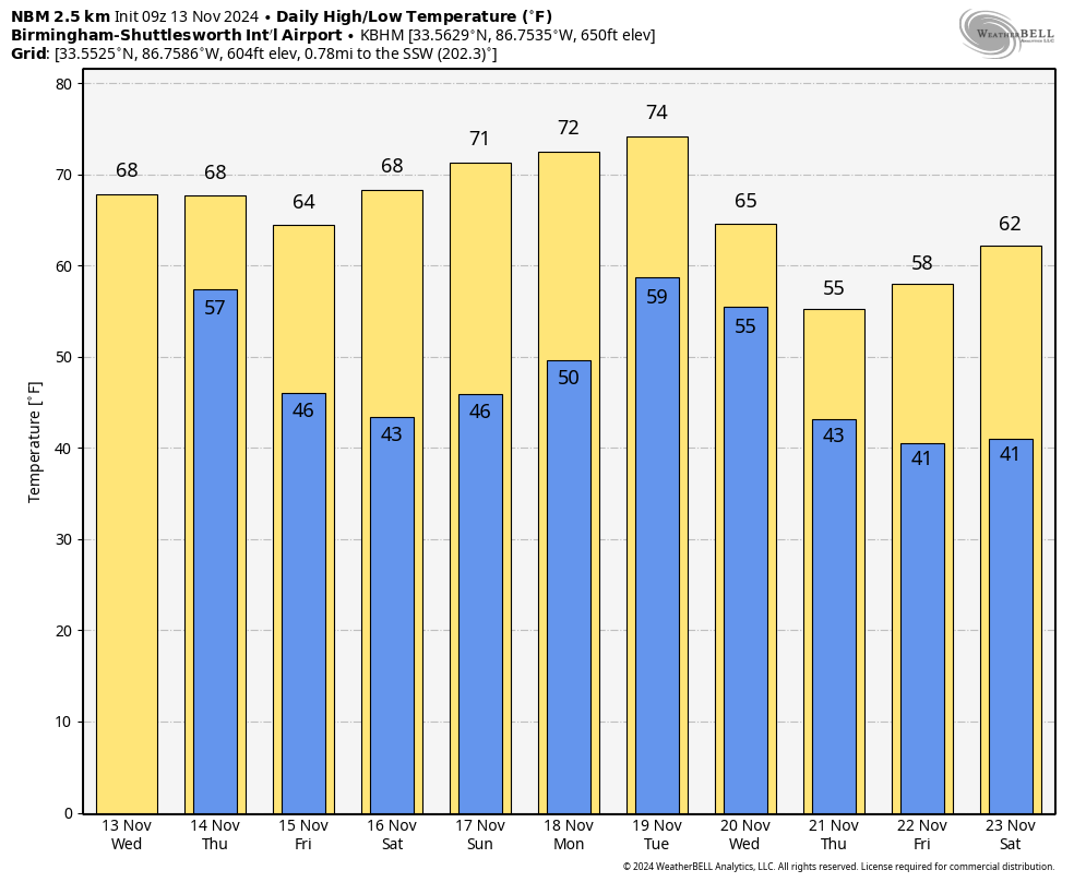
Rain will end Thursday morning from northwest to southeast across Alabama as a surface front pushes through. Highs will be between 67 and 71 degrees for most places today and Thursday.
FRIDAY AND THE WEEKEND: We’ll have perfect weather for the Deep South, with sunny, pleasant days and clear, cool nights. Colder spots across north Alabama could reach the mid to upper 30s early Saturday morning; otherwise, lows will be in the 40s. The high will be in the mid to upper 60s Friday, then close to 70 Saturday, followed by low to mid 70s Sunday.
NEXT WEEK: A major pattern change is ahead for North America. The ridge that has been keeping the Deep South warm and mostly dry will be replaced by a deep, long-wave upper trough. A surface front will bring showers Wednesday, followed by much colder air. Highs drop into the 50s Thursday and Friday, with lows in the 30s for much of north Alabama.
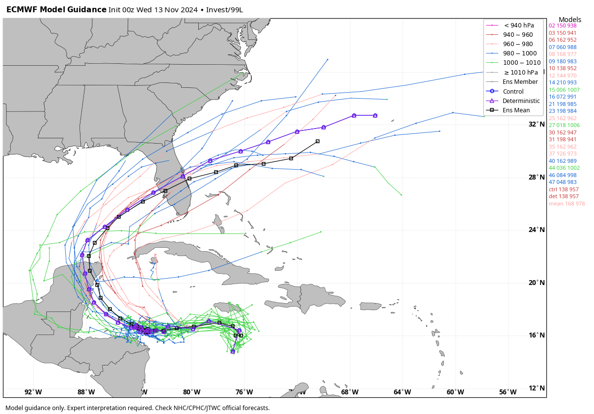
TROPICS: Showers and thunderstorms continue associated with a broad area of low pressure over the central Caribbean Sea. Environmental conditions appear conducive for development, and a tropical depression is likely to form within the next couple of days while the system moves slowly westward into the western Caribbean Sea. Further development is likely while the disturbance meanders over the western Caribbean Sea through the weekend. The system is forecast to begin moving slowly northwestward by early next week. Regardless of development, heavy rains are expected over Jamaica and portions of Haiti during the next day or so.
The National Hurricane Center gives the system a 90% chance of development, and most likely it becomes Tropical Storm Sara by the weekend. Most global models suggest Sara could become a hurricane over the southern Gulf of Mexico, and most of the ensemble members bring it into Florida somewhere south of Tampa Bay by the middle of next week.
Of course, until the system actually develops, gets a good core and we get dropsonde data from hurricane hunters, we won’t know the track or intensity. Confidence is high (based on the forecast upper air pattern) that this tropical system won’t affect the central Gulf Coast (Gulf Shores to Panama City Beach).
FOOTBALL WEATHER: It will be a perfect night for high school playoff games Friday night, a clear sky with temperatures falling through the 50s.
On Saturday, Auburn hosts Louisiana-Monroe at Jordan-Hare Stadium (11:45 a.m. kickoff). Expect a sun-filled sky with temperatures rising from the mid 60s at kickoff to near 70 by the final whistle.
Alabama hosts Mercer Saturday (1 p.m. kickoff) at Bryant-Denny Stadium. The sky will be sunny with temperatures between 67 and 70 degrees.
UAB plays at Memphis (7 p.m. kickoff). The sky will be clear with temperatures falling from the low 60s at kickoff into the low 50s by the fourth quarter.
ON THIS DATE IN 1833: In 1833, observers were familiar with the Leonid meteor shower, but the event that year was very intense and led to the first formulation of a theory on the origin of meteors. By some estimates, the 1833 Leonid meteor shower had 240,000 meteors in a nine-hour period.
For more weather news and information from James Spann and his team, visit AlabamaWx.


