James Spann: Cool March day ahead for Alabama; frost likely for many by Friday morning
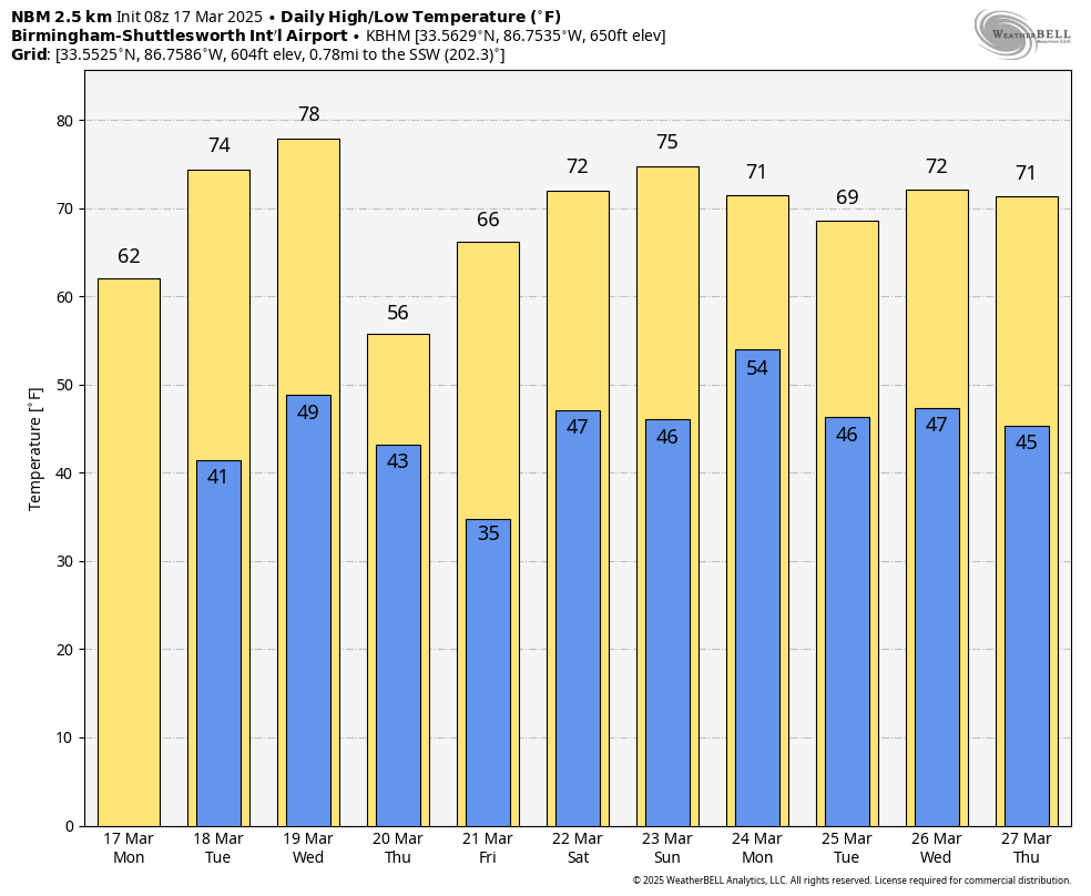
COOL: We have a few colder spots, in the low to mid 30s, across north Alabama early this morning with a clear sky; we are forecasting a high today between 58 and 65 degrees with sunshine in full supply. The average high for Birmingham on March 17 is 67.
Tuesday will be sunny and warmer, with a high in the 70s statewide.
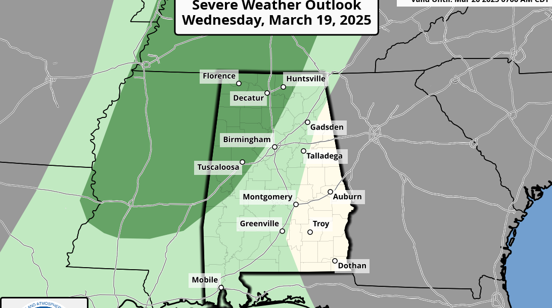
WEDNESDAY NIGHT COLD FRONT: Most of the day Wednesday will be dry and warm; many south Alabama communities will see a high in the low 80s. A cold front will bring a fast-moving band of showers and storms into the state Wednesday night. The Storm Prediction Center has defined a marginal risk (level 1 out of 5) of severe thunderstorms for areas north and west of Birmingham.
A few storms along the front could produce small hail and gusty winds, but with little surface-based instability and weak dynamic support, the overall threat is low.
Colder, drier air rolls into the Deep South Thursday. Highs will be in the 50s for the northern half of the state with a chilly north breeze. By Friday morning, we are looking at lows between 28 and 35 degrees over the northern half of the state, where frost is likely. Colder spots will see a late-season freeze. South Alabama will see lows between 38 and 44 degrees. During the day, the sky will be sunny with a high in the 60s.
THE ALABAMA WEEKEND: There is huge difference in the primary global model output, making for a very low-confidence forecast. The American Global Forecast System suggests most of the weekend will be dry, followed by a round of showers and storms Sunday night. But the reliable European global model suggests some rain on Saturday, followed by a dry day Sunday. We will have much better clarity later this week.
STORM SURVEYS: Storm survey work from National Weather Service Birmingham will continue today. So far, these are the tornado ratings from the weekend storms:
- Plantersville/Maplesville — EF-3
- Winterboro — EF-2
- Jackson’s Gap — EF-2
- Calera — EF-1
- West Shelby County — EF-1
- Bibb County — EF-0
- Hale/Perry counties — EF-0
Work will continue this week; at least 16 tornadoes likely touched down across Alabama, killing three people.
ON THIS DATE IN 1990: Showers and thunderstorms associated with a slow-moving cold front produced torrential rains across parts of the southeastern U.S. over two days. Flooding claimed the lives of at least 22 people, including 13 in Alabama. Up to 16 inches of rain deluged southern Alabama, with 10.63 inches reported at Mobile in 24 hours. Elba was flooded with 6 to 12 feet of water, causing more than $25 million damage, and total flood damage across Alabama exceeded $100 million. Twenty-six counties in the state were declared disaster areas.
ON THIS DATE IN 2021: Twenty-five tornadoes touched down in Alabama, including three rated EF-2. The longest-track tornado was around 36.5 miles, from Wayne County, Mississippi, to southern Marengo County. Other tornadoes occurred with this system from Louisiana and Mississippi to Georgia and Florida.
For more weather news and information from James Spann and his team, visit AlabamaWx.


