James Spann: Unsettled weather for Alabama through Saturday; dry air returns Sunday
WET AT TIMES: An unsettled weather pattern is ahead for Alabama through Saturday night as we deal with occasional showers and a few thunderstorms. A very humid air mass will remain parked across the state, and a surface front will slowly approach from the northwest.
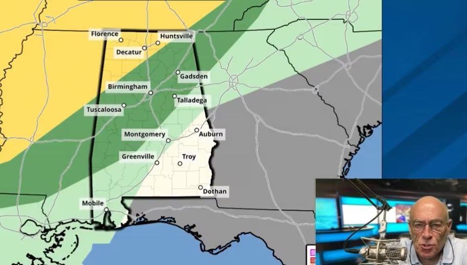
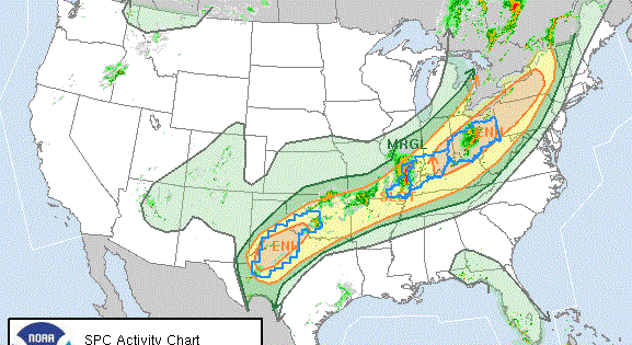
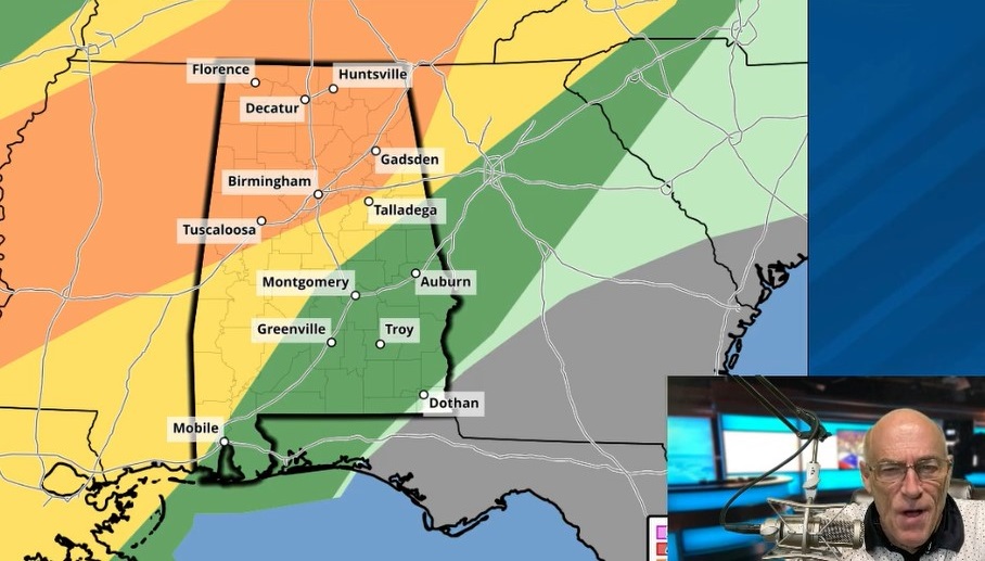
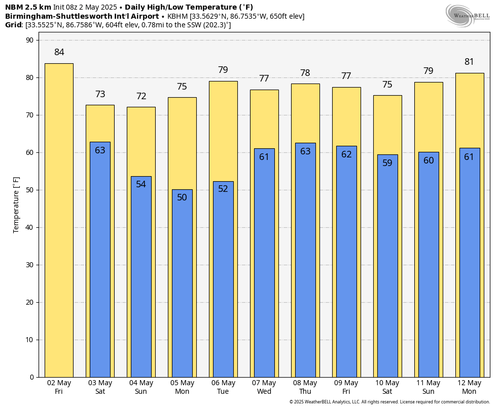
The Storm Prediction Center has most of the state in some type of severe thunderstorm risk this afternoon and tonight. Wind fields at the surface and aloft are relatively weak, and the dynamic support isn’t especially strong. But, during the peak of the daytime heating late this afternoon and this evening, a few storms could produce strong, gusty winds and some hail. Forecast wind profiles suggest no meaningful tornado threat. The highest coverage of showers and storms will be over the northern half of the state. The high this afternoon will be in the mid 80s in most places.
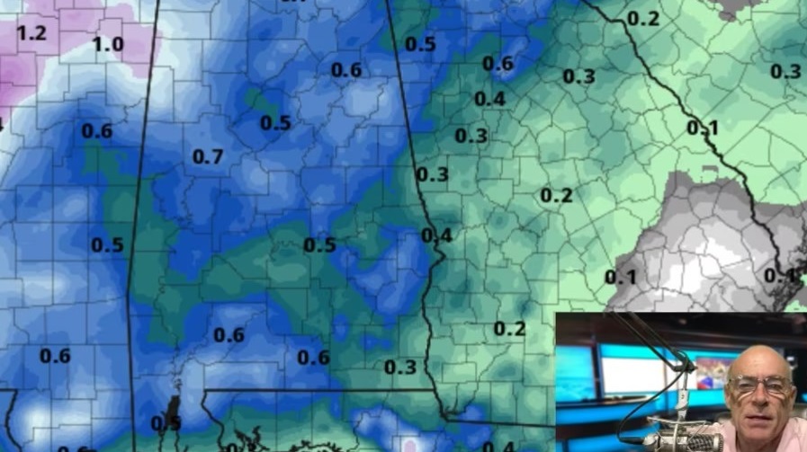
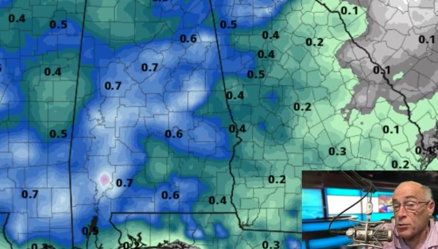
THE WEEKEND: Saturday will be mostly cloudy and cooler with periods of rain and a thunderstorm or two. There’s no concern over severe storms, with the air being more stable. Rain coverage will likely be higher than today as the surface front pushes into the northwest corner of the state. Still, it won’t rain all day, and the rain will end from northwest to southwest during the evening. By midnight all of the rain should be out of the state. The high will be between 70 and 75 degrees due to clouds and showers. Rain amounts between now and Saturday night will be 1-2 inches for much of Alabama.
The sky becomes partly to mostly sunny Sunday, although clouds could linger over the Tennessee Valley. The high will remain in the low to mid 70s.
NEXT WEEK: Many north Alabama communities will drop into the 40s early Monday morning as cooler air settles in. The weather will be dry Monday and Tuesday with highs in the mid to upper 70s. Global models are now suggesting an upper trough will bring periods of rain back into Alabama over the latter half of the week, Wednesday through Friday.
ON THIS DATE IN 1983: Severe thunderstorms produced 21 tornadoes across the northeastern states of Michigan, Ohio, Pennsylvania and New York. One tornado even occurred in Ontario, Canada. Of the 21 tornadoes in the United States, nine were rated F3 and six were rated F2. They caused five deaths.
ON THIS DATE IN 2010: May began with two days of historic rainfall over much of Middle Tennessee, with a massive swath stretching along the I-40 corridor from Benton County to Davidson County. Some areas received nearly 20 inches of rain during this two-day period, the highest of which was 19.41 inches reported in Camden, Tennessee. Many Nashville landmarks received damage from floodwaters, including Gaylord Opryland Hotel and the Grand Ole Opry. Other popular Nashville landmarks affected by the floods included LP Field, Bridgestone Arena, the Country Music Hall of Fame and the Schermerhorn Symphony Center, which received damage to the basement and its contents, including two Steinway grand pianos and the console of the Martin Foundation Concert Organ.
For more weather news and information from James Spann and his team, visit AlabamaWx.