James Spann: Dry air covers Alabama
James Spann: Mostly dry weekend for Alabama from Alabama NewsCenter on Vimeo.
TOUCH OF FALL: Sure feels good this morning; cooler spots are in the 50s across north Alabama. Here are some temperatures just before daybreak:
- Fort Payne — 55
- Black Creek (just northeast of Gadsden) — 57
- Cullman — 58
- Scottsboro — 59
- Russellville — 59
- Decatur — 60
- Pell City — 64
- Anniston — 66
- Birmingham — 67
- Tuscaloosa — 70
Look for a good supply of sunshine today and tomorrow with lower humidity levels; highs will be in the mid to upper 80s for most places.
THE WEEKEND: It now looks like Harvey will hold over south Texas, meaning no real impact on our state this weekend. Moisture levels will creep up, and we will mention the risk of scattered showers, but it looks like most of Saturday and Sunday will be dry with a partly sunny sky. Highs hold in the mid to upper 80s.
NEXT WEEK: Global models suggest potential for heavier rain from Harvey will hold off until the latter half of the week — just a few scattered showers around Monday and Tuesday, with rain chances increasing Wednesday. The highest rain potential seems to be Thursday, when the circulation center of Harvey will be just west of our state; some heavy rain is possible then.

HARVEY GETTING BETTER ORGANIZED IN THE GULF OF MEXICO: Satellite imagery overnight shows Harvey getting its act together. Winds have increased to 60 mph; it is now expected to reach hurricane strength before making landfall on the Texas coast near Corpus Christi tomorrow night.

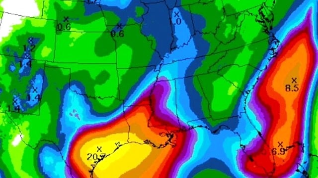
After landfall, steering currents will collapse, and Harvey is expected to meander across south Texas through early next week. Because of the lack of motion, this will set the stage for a serious flooding threat on the Texas coastal plain; rain amounts of 15 to 25 inches seem likely in the zone from Corpus Christi to Galveston, Houston and Port Arthur.
INVEST 92L: A disturbance over south Florida will move into the Atlantic early next week, and has some potential to develop into Tropical Storm Irma off the East Coast of the United States. No issues for Alabama from this one.
ON THIS DATE 25 YEARS AGO: Hurricane Andrew, one of only three category five hurricanes on record to strike the U.S., moved into south Florida. It was the costliest hurricane to make landfall anywhere in the United States until it was surpassed by Katrina in 2005. Andrew caused major damage in the Bahamas and Louisiana, but the greatest impact was felt in south Florida, with sustained wind speeds as high as 165 mph. Passing directly through the city of Homestead in Dade County, it stripped many homes of all but their concrete foundations. In total, it destroyed more than 63,500 houses, damaged more than 101,000 others, caused $26.5 billion in damages and left 65 people dead.
BEACH FORECAST: Click here to see the AlabamaWx Beach Forecast Center page.
WEATHER BRAINS: You can listen to our weekly 90-minute netcast anytime on the web, or on iTunes. This is the show all about weather featuring many familiar voices, including meteorologists at ABC 33/40.
CONNECT: You can find me on all of the major social networks:
Facebook
Twitter
Google Plus
Instagram
Pinterest
Snapchat: spannwx
For more weather news and information, visit AlabamaWx.


