James Spann: Dry, cool in Alabama today; rain returns Thursday
James Spann has the Alabama forecast to kick off the work week from Alabama NewsCenter on Vimeo.
COLDEST MORNING SO FAR THIS SEASON: Here are some temperatures across Alabama just before daybreak this morning:
- Nances Creek (east of Jacksonville) — 29
- Haleyville — 32
- Black Creek (northeast of Gadsden) — 32
- Fort Payne — 32
- Russellville — 32
- Valley Head — 32
- Decatur — 33
- Cullman — 34
- Gadsden (Noccalula Falls) — 34
- Haleyville — 34
- Pell City — 34
- Hueytown — 35
- Sylacauga — 36
- Anniston — 37
- Tuscaloosa — 39
- Birmingham — 40
Here’s a classic example of the UHI effect (Urban Heat Island): The record books will show a low of 40, based on data in the city at Birmingham, but most places are well down in the 30s.
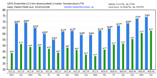
Today will be brilliantly sunny with a high close to 70 degrees.
TOMORROW/WEDNESDAY: Delightful fall weather continues with a good supply of sunshine both days. We project a high between 70 and 73 degrees; early morning lows will be mostly in the 40s.
THURSDAY/FRIDAY: Wave energy associated with Hurricane Willa, now approaching the coast of Mexico in the eastern Pacific, will help to generate a surface low in the northern Gulf of Mexico, and will bring rain back to Alabama. At this point it looks like the main window for rain comes from about 3 Thursday afternoon through noon Friday. Rain amounts for the northern half of Alabama should be generally around one-half inch, with totals over the southern counties of the state closer to 1 inch.
With the surface low to the south, along with clouds and periods of rain, temperatures will have a hard time getting out of the 50s both days.
THE ALABAMA WEEKEND: At this point the weather looks cool and dry Saturday and Sunday — partly to mostly sunny both days with highs in the low to mid 60s. Early morning lows will be generally in the 40s. An upper trough will pass over the state Sunday with some clouds, but for now the air looks a bit too dry for any meaningful precipitation.
NEXT WEEK: The first half of the week looks dry, but some rain returns by Thursday or Friday with an approaching cold front.
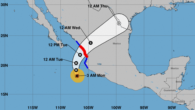
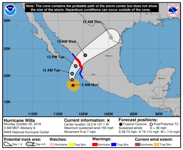
TROPICS: The Atlantic basin is quiet, but dangerous Hurricane Willa, with sustained winds of 155 mph, is approaching the coast of Mexico in the eastern Pacific. Landfall is expected tomorrow afternoon; it will weaken quickly over land, but some of the moisture will feed up into south Texas by Wednesday and Thursday.
BEACH FORECAST: Click here to see the AlabamaWx Beach Forecast Center page.
WEATHER BRAINS: You can listen to our weekly 90-minute show any time on your favorite podcast app. This is the show all about weather featuring many familiar voices, including meteorologists at ABC 33/40.
CONNECT: You can find me on all of the major social networks:
Facebook
Twitter
Instagram
Pinterest
Snapchat: spannwx
For more weather news and information from James Spann and his team, visit AlabamaWx.


