James Spann: Severe storms possible in Alabama later today, tonight
James Spann forecasts an active weather day for Alabama from Alabama NewsCenter on Vimeo.
WINDY DAY: A deep surface low this morning over the Great Plains will move slowly northeast, dragging a cold front into Alabama tonight. Ahead of that front, today will be mild and windy, with a high in the 70s. A strong south wind will average 15-25 mph, with occasionally higher gusts. The air will become unstable this afternoon, and strong to severe thunderstorms are possible through tonight.
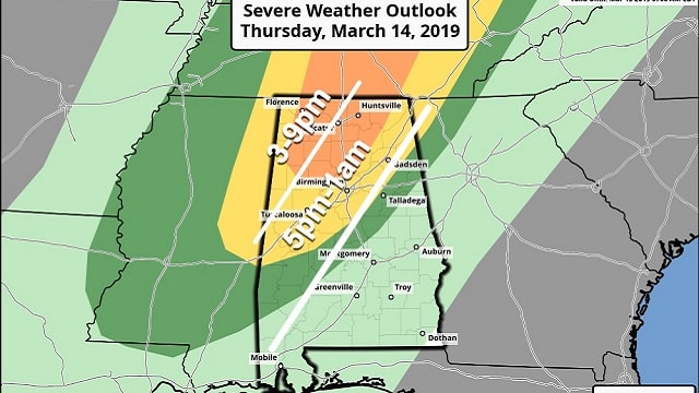
The Storm Prediction Center has introduced an enhanced risk (level 3 of 5) for parts of north Alabama, including places like Cullman, Jasper, Haleyville, Decatur and Huntsville. A slight risk (level 2 of 5) extends as far south as Demopolis, Calera and Weiss Lake. And a marginal risk runs down to Grove Hill, Rockford and Heflin.
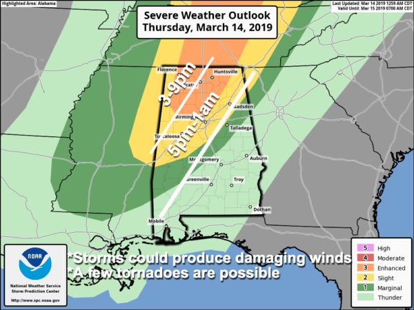
TIMING: The window for strong to severe storms across northwest Alabama runs from 3 until 9 p.m.; for Central Alabama, it’s from 5 p.m. until 1 a.m. A tornado watch is already in effect for parts of Arkansas, Mississippi, Missouri and Tennessee until noon.
THREATS: Heavier storms will be capable of producing strong, potentially damaging winds, hail and a few tornadoes.
GRADIENT WIND: Even with no thunderstorms involved, pressure gradient winds today out of the south could gust as high as 30 mph, maybe even up to 40 mph on ridges.
RAIN: Rain amounts will be less than 1 inch for most communities, and we don’t expect any flooding.
CALL TO ACTION: Be sure you can hear severe weather warnings. Every Alabama home and business needs a NOAA Weather Radio; NEVER rely on a siren. Have WEA (Wireless Emergency Alerts) enabled on your phone, and get a good app designed for warnings like this one.
Know where you are going in the event you are under a tornado warning polygon, and in that safe place have helmets (bicycle helmet, batting helmet, etc.) for everyone. It is a good idea to have hard-sole shoes and a portable air horn for everyone. And never be in a car or a manufactured home in a tornado warning polygon. Review your plan with your family.
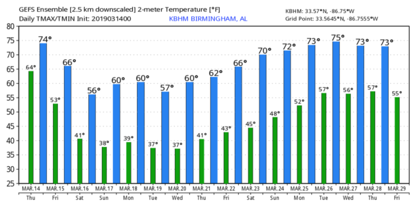
TOMORROW AND THE WEEKEND: Noticeably cooler air will roll into Alabama tomorrow. Lingering showers during the morning over the northern half of the state will end, and the sky becomes partly sunny by afternoon. Showers, however, are still possible over the southern half through the entire day. The high tomorrow will be in the 60- to 65-degree range for north and central Alabama.
The weekend will be dry with a good supply of sunshine Saturday and Sunday. Mornings will be chilly, with lows in the 30s. Frost is likely early Sunday, when the wind will be near calm, and colder spots will see a freeze. The high Saturday will be between 58 and 61, and low 60s are likely Sunday afternoon.
NEXT WEEK: The week will be dry with mostly sunny, cool days and clear, cold nights — highs mostly in the 60s, lows mostly in the 30s.
ON THIS DATE IN 1993: The official low in Birmingham was 2 degrees above zero, easily the coldest March temperature on record. It came with a clear sky, light wind and a huge blanket of snow on the ground following the “Blizzard of ’93.”
WEATHER RADIO PROGRAMMING IN JACKSONVILLE: We will be in Jacksonville next Monday night, March 18, programming weather radios. Bring your weather radio and we will check it for you; we will be on the fifth floor of Jacksonville State University Stadium from 4 until 6:30 p.m. I will be there doing weather live on ABC 33/40.
BEACH FORECAST: Click here to see the AlabamaWx Beach Forecast Center page.
WEATHER BRAINS: You can listen to our weekly 90-minute show any time on your favorite podcast app. This is the show all about weather featuring many familiar voices, including the meteorologists at ABC 33/40.
CONNECT: You can find me on the major social networks:
Facebook
Twitter
Instagram
Pinterest
Snapchat: spannwx
For more weather news and information from James Spann and his team, visit AlabamaWx.


