James Spann: Spring-like today in Alabama; strong storms Wednesday
James Spann has the Alabama forecast for the work week ahead from Alabama NewsCenter on Vimeo.
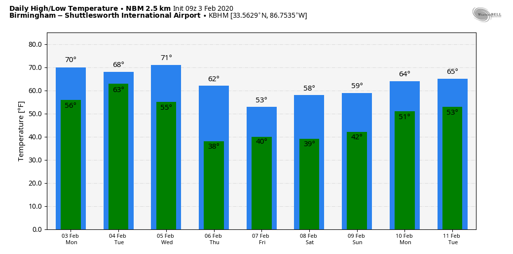
BIG WARM-UP TODAY: Temperatures are all over the board this morning; across north Alabama at 5 a.m. they range from 32 at Fort Payne to 55 at Muscle Shoals. But everyone warms up nicely today as temperatures climb toward the 70-degree mark with a partly to mostly sunny sky. The average high for Birmingham on Feb. 3 is 56.
Clouds will increase tonight with some rain possible after midnight, and Tuesday will be a cloudy, mild and breezy day with occasional showers for the northern half of Alabama. It won’t rain all day, and there is no risk of severe thunderstorms. The high will be in the upper 60s.
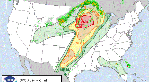
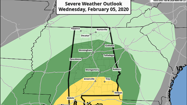
STRONG TO SEVERE STORMS POSSIBLE WEDNESDAY: An approaching weather system will bring rain and storms to the state Wednesday and Wednesday night; the Storm Prediction Center has defined a slight risk (level 2 out of 5) of severe storms for parts of south Alabama, south of a line from Grove Hill to Fort Deposit to Troy to Abbeville. A marginal risk (level 1 of 5) is as far north as Winfield, Cullman and Centre.
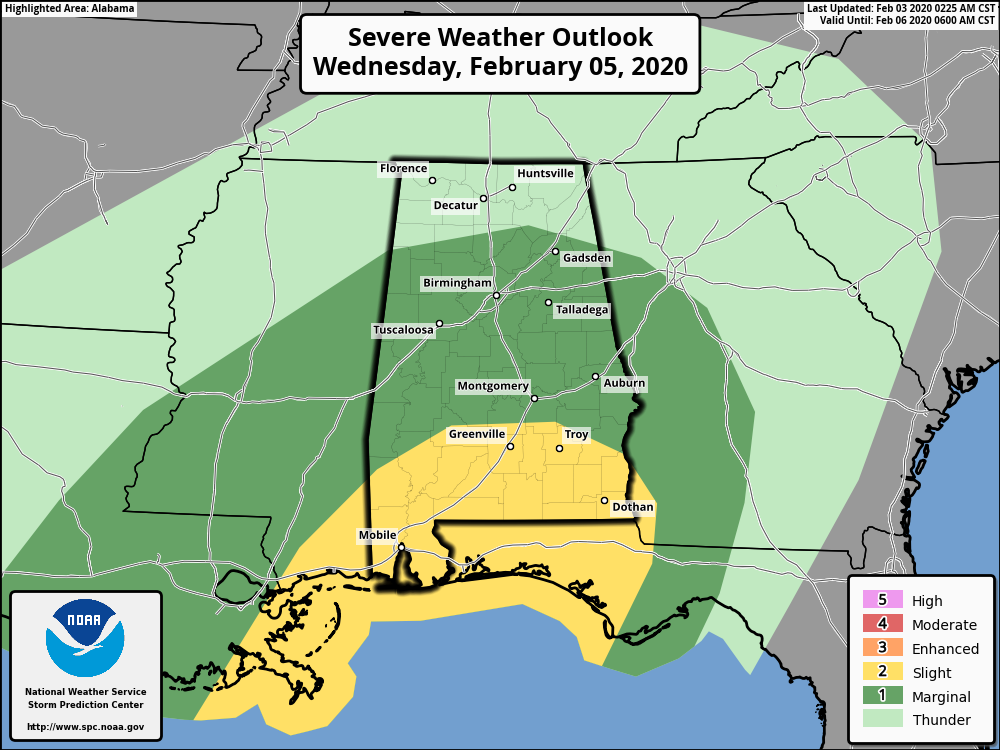
There is a decent chance we will have periods of rain through most of the day Wednesday, which will limit the instability and keep the thermodynamic fields from becoming really favorable for a big severe weather day. The highest risk of severe storms will come over the southern third of the state late Wednesday and Wednesday night, where the air will be most unstable.
For north and central Alabama, heavier storms Wednesday and Wednesday night could produce small hail and gusty winds. A brief, isolated tornado can’t be ruled out. The main window for the stronger storms will come from noon until midnight.
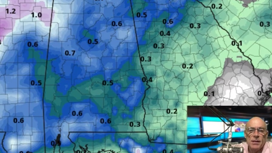
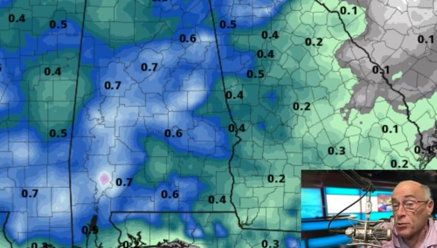
Thursday will be cooler with lingering light rain at times; temperatures will hold in the mid 50s. Rain amounts Tuesday through Thursday will be in the 2- to 3-inch range for most of Alabama. A few isolated flooding issues are possible, especially with the heavier rain Wednesday and Wednesday night.
FRIDAY AND THE WEEKEND: Friday and Saturday will be cool and mostly dry; the sky will be occasionally cloudy, and a few patches of light rain can’t be totally ruled out (but not especially likely). The high Friday will be in the low 50s, followed by mid to upper 50s Saturday. Sunday should be a nice day with ample sunshine along with a high around 60 degrees.
NEXT WEEK: Looks like the next chance of rain will come Tuesday night into Wednesday of next week; too early to know if strong storms will be an issue. Highs will be in the 60s for the first half of the week, dropping back into the 50s by Thursday and Friday. There’s still no sign of any bitterly cold, Arctic air for Alabama over the next seven to 10 days.
ON THIS DATE IN 1947: The record-low temperature for continental North America was recorded in Snag, in the Yukon Territory, Canada. The temperature was 81.4 degrees below zero.
BEACH FORECAST: Click here to see the AlabamaWx Beach Forecast Center page.
WEATHER BRAINS: You can listen to our weekly 90-minute show any time on your favorite podcast app. This is the show all about weather featuring many familiar voices, including the meteorologists at ABC 33/40.
CONNECT: You can find me on the major social networks:
Facebook
Twitter
Instagram
Pinterest
Snapchat: spannwx
For more weather news and information from James Spann and his team, visit AlabamaWx.