James Spann: Severe storms possible in Alabama again Thursday

James Spann forecasts quiet weather for Alabama before storms return Thursday from Alabama NewsCenter on Vimeo.
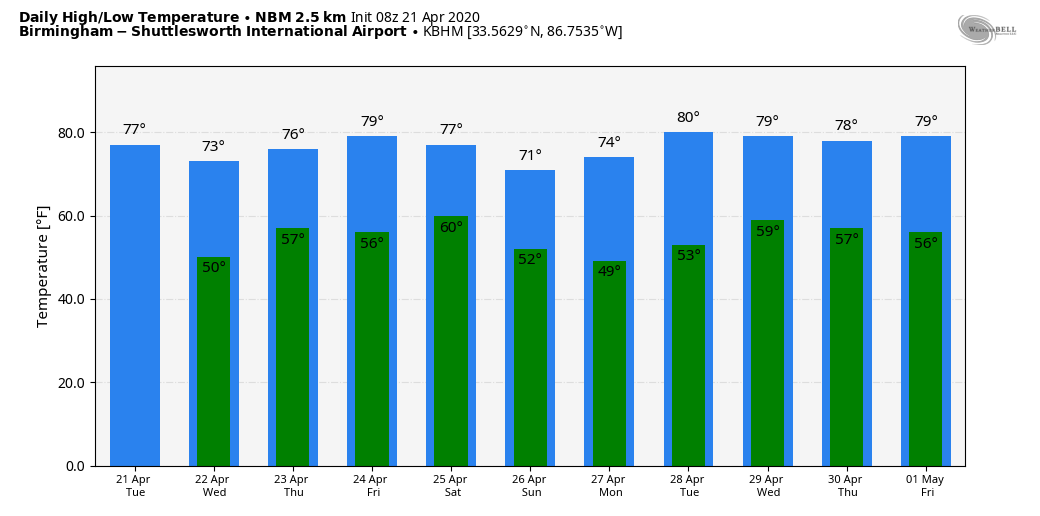
QUIET DAY AHEAD: Dry weather continues across Alabama today, despite a cold front passing through. No moisture means no rain and not many clouds. The high will be in the 70s this afternoon. Fair weather continues tonight, and most of Wednesday will be dry, although there should be a gradual increase in clouds.
MORE STRONG TO SEVERE STORMS THURSDAY: Another dynamic weather system will bring a severe weather threat to Alabama Thursday. Rain and storms should enter the state after midnight Wednesday night. These storms will be potentially strong to severe, but they will most likely be elevated. The Storm Prediction Center has a low-end severe weather risk (marginal to slight) over the western half of the state for the early morning activity.
Then, during the day Thursday, the SPC has defined an enhanced risk (level 3 out of 5) of severe thunderstorms for most of the state from Birmingham south and east. There is a slight risk (level 2 of 5) as far north as Vernon, Guntersville and Fort Payne, and a marginal risk (level 1 of 5) up to the Tennessee state line.
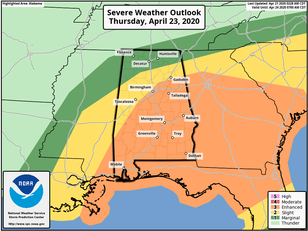
Confidence is high in the threat of severe thunderstorms Thursday over the southern third of the state, where the air will be very unstable and wind fields will be strong. The threat to north Alabama is more conditional; it all depends on how the morning round of storms plays out, the northward extent of the unstable air and any small-scale boundaries left over.
Storms over south Alabama Thursday will be capable of producing large hail, damaging winds and a few tornadoes. A few strong (EF2 or higher) tornadoes can’t be ruled out. We will have much better clarity on timing this afternoon after the 12Z model set arrives. But it will be a day when you want to hear all severe weather warnings (including severe thunderstorm warnings) and have your action plan ready if you are in a polygon.
FRIDAY AND THE WEEKEND: Friday will be a dry day with a partly sunny sky and a high in the upper 70s. But another fast-moving weather system will bring yet another round of rain and storms to the state late Friday night, mainly after midnight, into early Saturday morning. There will some unstable air involved, and these storms could possibly be strong to severe. We need to get past the Thursday event before we can really focus on this one. The sky will clear late in the day Saturday, and Sunday will be quiet with ample sunshine and a high in the low 70s.
NEXT WEEK: Monday and Tuesday look dry; then the next storm system arrives at some point in the Wednesday/Thursday time frame.
STORM SURVEY RESULTS: National Weather Service survey teams have determined that the damage in Chilton, Coosa and Tallapoosa counties early Sunday morning was caused by a wide swath of damaging straight-line winds. Winds were in the 80-90 mph range in Chilton County and in the 70-80 mph range over Coosa and Tallapoosa counties.
The storms were in a cool, stable air mass near the surface with temperatures in the low to mid 50s. With damage like this, we are often confronted with people insisting it was a tornado in places like Thorsby, Hanover and Alexander City. Yes, there was rotation aloft, and you might have seen a funnel cloud, but the low-level thermodynamic environment would not allow a tornado to drop. This is a stark reminder that straight-line winds can produce tornado-like damage, and are very dangerous and a threat to life. In the weather enterprise, we have to do a better job of reminding people to take severe thunderstorm warnings seriously.
ON THIS DATE IN 1967: Severe thunderstorms spawned 48 tornadoes in the Upper Midwest. Hardest hit was northern Illinois, where 16 tornadoes touched down during the afternoon and evening, causing $50 million damage. On that Friday afternoon, tornadoes struck Belvidere, Illinois, and the Chicago suburb of Oak Lawn, killing 58 people.
WEATHER BRAINS: You can listen to our weekly 90-minute show anytime on your favorite podcast app. This is the show all about weather featuring many familiar voices, including the meteorologists at ABC 33/40.
CONNECT: You can find me on the major social networks:
Facebook
Twitter
Instagram
Pinterest
Snapchat: spannwx
For more weather news and information from James Spann and his team, visit AlabamaWx.


