James Spann: Windy day ahead for Alabama, with strong to severe storms later today, tonight
James Spann forecasts a potentially stormy afternoon and night for Alabama from Alabama NewsCenter on Vimeo.
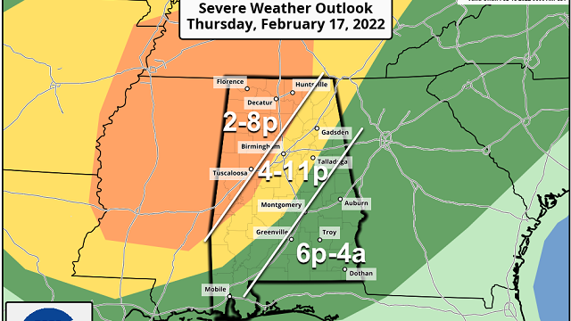
ACTIVE WEATHER DAY: We have a very active weather day ahead as a dynamic storm system approaches. Strong to severe thunderstorms are possible this afternoon and tonight. The Storm Prediction Center maintains an enhanced risk (level 3 out of 5) of severe thunderstorms for parts of north and west Alabama, west of a line from Hytop to Hueytown to Demopolis. A slight risk (level 2) extends as far east as Anniston, Prattville and Grove Hill, and the rest of the state (east and south Alabama) is in a marginal risk (level 1).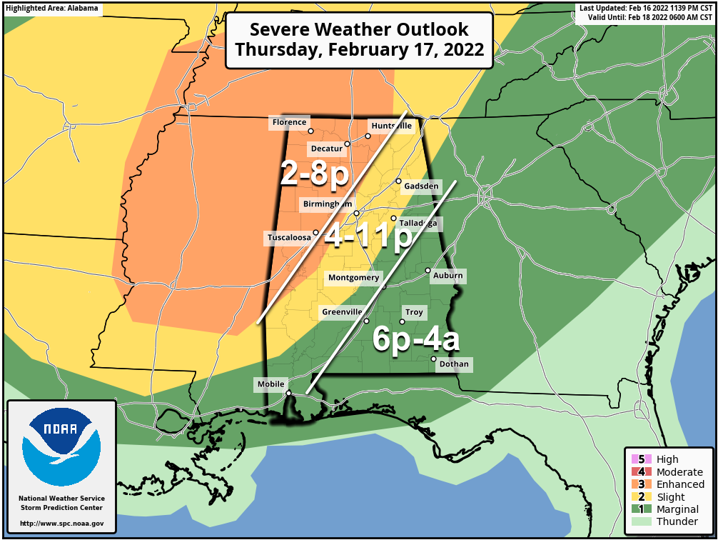 GRADIENT WIND: Strong south winds will develop across Alabama today (not related to thunderstorms). Wind gusts to 40-45 mph are possible this afternoon and early tonight; this could bring some scattered power outages and bring down weakened trees. It will be a very windy day.
THUNDERSTORM TIMING: We have a few thunderstorms across northwest Alabama early this morning, but in terms of the severe weather threat, the main window in the enhanced risk area is from 2 until 8 p.m. For the slight risk area (places like Birmingham, Anniston and Gadsden), the main window comes from 4 until 11 p.m., and for the marginal risk area in east and south Alabama the window is from 6 p.m. until 4 a.m.
THREATS: Stronger storms will be capable of producing hail, strong winds and a few tornadoes. The highest tornado threat is in the enhanced risk area across north and west Alabama, and a strong tornado (EF-2 or higher) can’t be ruled out.
RAIN: Amounts will be generally 1 to 1.5 inches for most of the state over the next 24 hours; flooding is not expected since the storms will be moving along at a good clip.
Days like this are common in February in Alabama; our tornado season runs from November through May. Just be sure you have a reliable way of hearing warnings (never an outdoor siren) and know your safe place. In that place, have helmets for everyone, including adults. If you live in a mobile home, know where you are going (you can’t stay there if you are in a tornado warning polygon) and arrange for transportation.
You can be a big part of the warning process. If you know someone who is in a tornado warning polygon, be sure and call or text them to let them know of the danger and to turn on our live coverage.
FRIDAY THROUGH THE WEEKEND: The sky becomes partly to mostly sunny Friday and the day will be much cooler, with a high between 48 and 52 degrees. Over the weekend, look for sunny days with a high in the upper 50s Saturday, followed by mid 60s Sunday.
NEXT WEEK: Much of the week looks wet. Moist air returns Monday with occasional showers, and there will be some risk of rain at times daily through at least Thursday. We could see a few thunderstorms along the way, but at the moment we aren’t seeing any major severe weather signals in modeling. The week will be mild, with highs in the 60s and low 70s.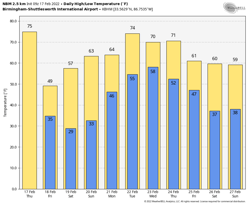 ON THIS DATE IN 1926: A deadly avalanche, Utah’s worst, demolished 14 miners’ cottages and a three-story boarding house in Bingham Canyon. Thirty-six were killed and 13 injured.
ON THIS DATE IN 2008: Thirteen tornadoes touched down across the southeast half of Alabama, including an EF-3 that moved through Prattville, injuring at least 50 people. That twister moved across U.S. Highway 82, U.S. Highway 31 and Cobbs Ford Road; an estimated 200 homes and 40 businesses were damaged or destroyed. Hundreds of trees were either snapped off or were uprooted along the path.
BEACH FORECAST: Click here to see the AlabamaWx Beach Forecast Center page.
WEATHER BRAINS: You can listen to our weekly 90-minute show any time on your favorite podcast app. This is the show all about weather featuring many familiar voices, including the meteorologists at ABC 33/40.
CONNECT: You can find me on the major social networks:
For more weather news and information from James Spann and his team, visit AlabamaWx.


