James Spann: Alabama stays dry Friday; showers return over the weekend
SUNNY APRIL AFTERNOON: Most of Alabama is enjoying sunshine in full supply this afternoon; temperatures are between 66 and 74 degrees. Some clouds are lingering across the southeast counties, but most places will be clear tonight with a low in the 40s. Friday will be dry with ample sunshine and a high in the upper 70s. EASTER WEEKEND: Clouds move in Friday night, and showers and a few storms will likely push into the state after midnight. A few strong storms are possible early Saturday morning across northwest Alabama, where the Storm Prediction Center has defined a marginal risk of severe storms.
During the day Saturday, the sky will be generally cloudy with occasional showers and a few thunderstorms. This won’t be a washout or an all-day rain, but it will be wet at times. A strong thunderstorm is possible over the southern half of the state; the SPC maintains a marginal risk (level 1 of 5) for areas south of a line from Aliceville to Montgomery to Abbeville. Stronger storms in that area could produce small hail and strong, gusty winds; there is no tornado threat. The high will be between 71 and 76 degrees.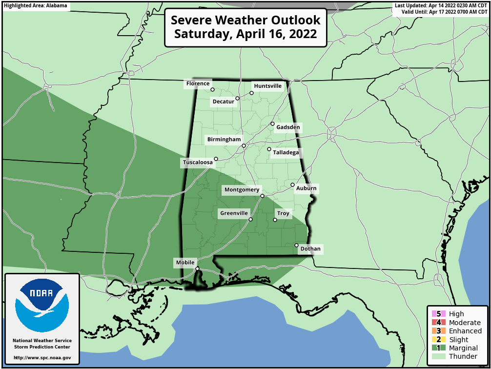 Clouds will linger on Easter and a few passing showers are likely during the day. But, like Saturday, the day won’t be a washout. The high Sunday will be in the mid 70s.
NEXT WEEK: A few lingering showers are possible Monday. Most of the state will be dry Tuesday and Wednesday. A cold front will bring a chance of showers and storms Thursday; for now it doesn’t look like a severe weather setup.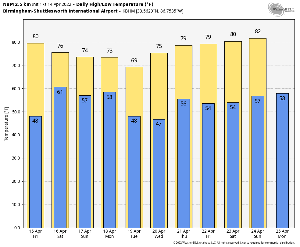 FOOTBALL WEATHER: For the Alabama A Day game in Tuscaloosa Saturday (2 p.m. kickoff), the sky will be cloudy with a few passing showers and possibly a thunderstorm. Temperatures will be in the low to mid 70s.
The Birmingham Stallions will host the New Jersey Generals Saturday evening at Protective Stadium (6:30 kickoff). Expect a cloudy sky with a few showers; temperatures will fall from near 72 at kickoff into the upper 60s by the final whistle.
LAST NIGHT’S STORMS: National Weather Service damage surveys are being conducted today; the damage in the Branch Heights section of Eutaw (Greene County) was caused by an EF-0 tornado. We’re still awaiting survey results in Northport, in the Flatwoods neighborhood.
ON THIS DATE IN 1886: The deadliest tornado in Minnesota history razed parts of St. Cloud and Sauk Rapids, leaving 72 dead and 213 injured. Eleven members of a wedding party were killed, including the bride and groom. The bottom of the Mississippi River was seen during the tornado’s crossing.
ON THIS DATE IN 1935: Black Sunday refers to a particularly severe dust storm that occurred as part of the Dust Bowl. During the afternoon, the residents of the Plains States were forced to take cover as a “black blizzard” blew through the region. The storm hit the Oklahoma Panhandle and northwestern Oklahoma first and moved south for the remainder of the day.
ON THIS DATE IN 2019: A total of 11 tornadoes touched down across Alabama on Palm Sunday; they were all short lived and rated either EF-0 or EF-1.
BEACH FORECAST: Click here to see the AlabamaWx Beach Forecast Center page.
WEATHER BRAINS: You can listen to our weekly 90-minute show any time on your favorite podcast app. This is the show all about weather featuring many familiar voices, including the meteorologists at ABC 33/40.
CONNECT: You can find me on the major social networks:
For more weather news and information from James Spann and his team, visit AlabamaWx.


