James Spann: Unsettled weather for Alabama through Saturday
James Spann forecasts a warm-up for Alabama after a cool start from Alabama News Center on Vimeo.
James Spann forecasts a wet day for Alabama from Alabama News Center on Vimeo.
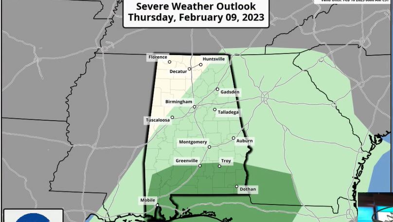
RADAR CHECK: Rain continues across much of Alabama early this morning, and gradient winds (not related to thunderstorms) are strong over the northern half of the state. Winds have gusted to 35 mph at Birmingham within the hour. While the rain will taper off over north and west Alabama later today, wet weather persists across the southern counties of the state this afternoon. A few strong storms are possible across south Alabama; the Storm Prediction Center maintains a low-end marginal risk (level 1 out of 5) of severe thunderstorms there.
Temperatures will hold between 58 and 65 degrees across most of Alabama today. Friday will be mostly cloudy with some rain possible, mainly over the southern counties. The high will be between 60 and 65 degrees for most places.
THE ALABAMA WEEKEND: A deep upper trough will move slowly over the state Saturday. The day will be cloudy and cooler with periods of rain; temperatures will be in the 40s and 50s. For now, forecast thermal values don’t support any chance of light snow, but these cold-core systems can bring surprises. On Sunday, the sky becomes mostly sunny with highs generally in the 50s.
NEXT WEEK: The weather Monday will be dry and pleasant with a good supply of sunshine; the high will be in the 60s. A batch of rain and potential thunderstorms will move into the state Tuesday night. A front will stall out over the state Wednesday and keep the weather wet at times over the latter half of the week. Highs will be mostly between 65 and 70 degrees.
ON THIS DATE IN 1973: One of the greatest snowstorms in southeastern United States history occurred Feb. 9-11. This storm dropped 1 to 2 feet of snow across a region that typically sees only an inch or 2 of snow per year. In Alabama, the heaviest snow was over the southeast counties of the state, where almost 1 foot was measured in some parts of Butler and Crenshaw counties, south of Montgomery.
ON THIS DATE IN 1994: A devastating ice storm struck Mississippi, Louisiana and extreme northwest Alabama. Freezing rain began falling over northern Mississippi during the early morning and continued until midday on Feb. 10. Ice accumulated 3 to 6 inches thick on exposed objects in the affected area. Due to the weight of the ice, power lines, trees and tree limbs were down. Nearly 1 million people were without power after the storm, some for a month.
In Alabama, seven counties over the northwest part of the state were devastated. Trees blocked roads, which were already impassable because of the ice glaze. Rainfall of 3 to 5 inches occurred, resulting in a heavy glaze and even causing flooding elsewhere.
BEACH FORECAST: Click here to see the AlabamaWx Beach Forecast Center page.
For more weather news and information from James Spann and his team, visit AlabamaWx.


