Scott Martin: One more day before the muggies, storms return to Alabama
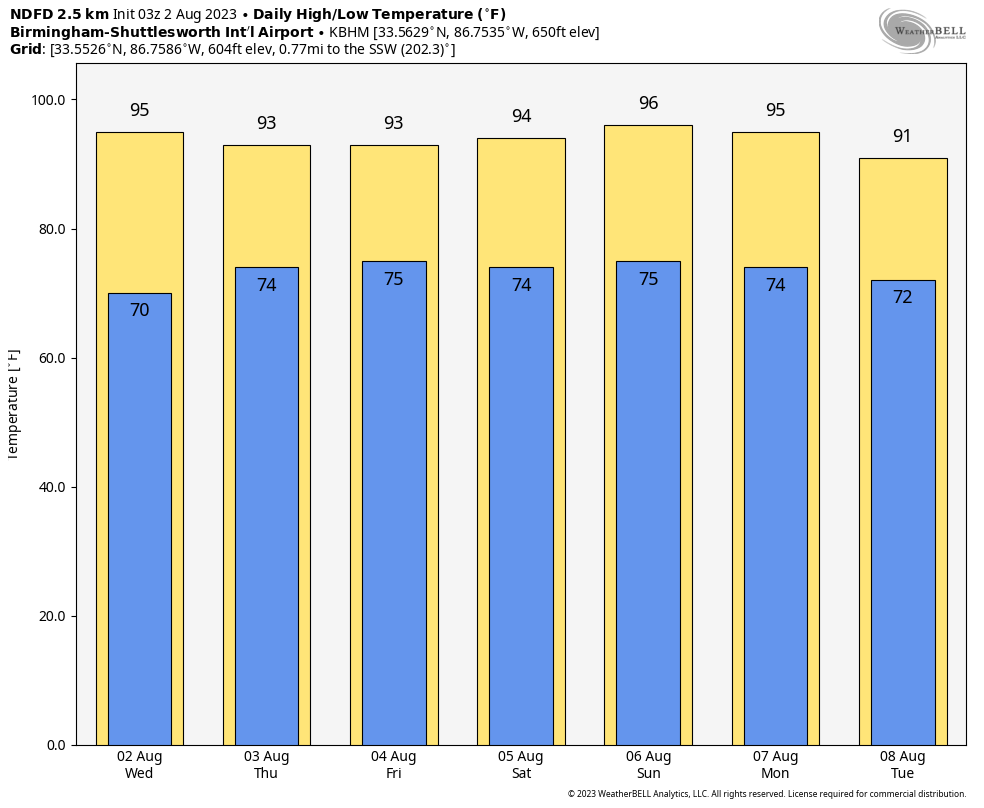
TUESDAY’S HIGHS:
- 100 – Troy
- 97 – Montgomery
- 95 – Tuscaloosa
- 94 – Anniston
- 94 – Shelby County Airport
- 91 – Birmingham
TODAY: It looks like we may squeeze in one more day of dewpoints remaining below 70 on Wednesday, as the ridge to our west will take just a tad longer to weaken. Nearly everyone will remain dry. We could see some convective activity move in from the northwest during the late afternoon through the evening, but rain chances remain small. You will notice the humidity starting to climb late. Highs will be in the lower to mid 90s.
THE REST OF THE WEEK: The flow will be out of the southwest to south on Thursday, which will continue the increase of humidity in Alabama. It will be hot and muggy with a good chance of scattered storms during the afternoon to early evening. Highs will be in the upper 80s to the mid 90s.
Friday will be much the same, with a good chance of scattered storms mainly during the afternoon but possible throughout the entire day. There will be a bit of a breeze, gusting up to 20 mph at times. It will be hot and muggy, with highs in the upper 80s to the mid 90s.
THE ALABAMA WEEKEND: Saturday and Sunday look more typical for late summer in Alabama, hot and humid with scattered afternoon storms possible. We’ll be in the 90s both days.
NEXT WEEK: Our weather stays active. A front sweeps into Alabama on Monday, bringing more scattered to numerous showers and storms. Highs will be in the lower to mid 90s.
On Tuesday, the front looks to stall out just to our south and will keep scattered storms possible across the southern half of the state, while locations a bit north of I-20 will stay dry. Highs will be in the mid 80s to the mid 90s.
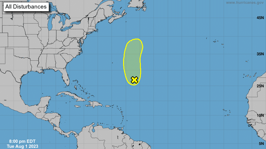
TROPICS: Showers and thunderstorms remain disorganized in association with a low-pressure area about 600 miles southeast of Bermuda. Environmental conditions are becoming less favorable for tropical cyclone formation, and the low is expected to move northward and merge with a frontal system over the north-central Atlantic in two to three days. The chance of formation through the next seven days is 20%.
ON THIS DATE IN 1989: Low pressure representing the remains of Hurricane Chantal deluged north central Texas with heavy rain. Up to 6.5 inches drenched Stephens County, and Wichita Falls reported 2.22 inches in just one hour.
BEACH FORECAST CENTER: Get the latest weather and rip current forecasts for the beaches from Dauphin Island to Panama City Beach, Florida, on our Beach Forecast Center page. There, you can select the forecast of the region you are interested in.
For more weather news and information from James Spann, Scott Martin and other members of the James Spann team, visit AlabamaWx.


