Scott Martin: Mostly cloudy, much warmer today in Alabama
THE WEEKEND: Expect mostly cloudy skies today, with temperatures warming up nicely into the mid 60s to lower 70s. There’s a chance of isolated showers and storms, particularly along and south of the I-85 corridor in southeastern Alabama.
Sunday will be similar to Saturday, with patchy morning fog followed by mostly cloudy skies. There’s a slight chance of scattered showers and storms, but most areas are likely to remain dry. Highs will range from the mid to upper 70s.
THE WORK WEEK: The moist, active pattern continues Monday, bringing the possibility of scattered showers and storms, especially during the afternoon with daytime heating. Skies will remain mostly cloudy, with temperatures reaching the mid to upper 70s.
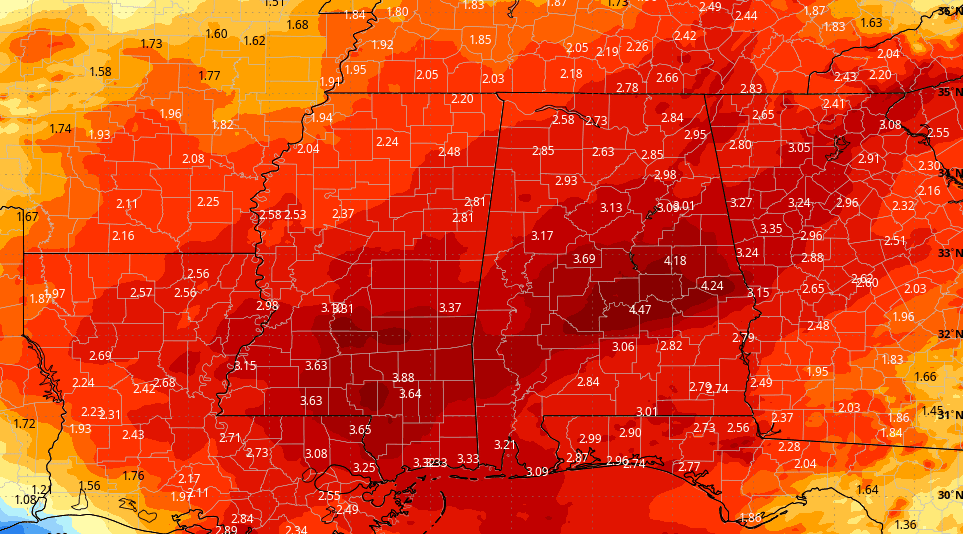
A slow-moving system approaches on Tuesday, bringing rain and storms. While severe storms aren’t expected due to limited instability and weak shear, rainfall totals could reach 1 to 2 inches, potentially causing localized minor flooding in low-lying areas. Highs will be in the upper 60s to lower 70s.
Most of the rain clears out by Wednesday morning, though a few wrap-around light showers or drizzle may persist throughout the day. Expect partly cloudy skies with highs in the 70s.
Thursday looks dry during the day, although another system approaches from the west with uncertain timing. Skies will be partly cloudy and temperatures will remain in the 70s.
A surface low situated to the southwest will pull moisture into Alabama Friday, leading to likely rain and storms. While instability levels are expected to remain low, severe weather isn’t anticipated. Highs will range from the upper 60s to mid 70s.
For more weather news and information from James Spann, Scott Martin and other members of the James Spann team, visit AlabamaWx.
THE WEEKEND: Expect mostly cloudy skies today, with temperatures warming up nicely into the mid 60s to lower 70s. There’s a chance of isolated showers and storms, particularly along and south of the I-85 corridor in southeastern Alabama.
Sunday will be similar to Saturday, with patchy morning fog followed by mostly cloudy skies. There’s a slight chance of scattered showers and storms, but most areas are likely to remain dry. Highs will range from the mid to upper 70s.
THE WORK WEEK: The moist, active pattern continues Monday, bringing the possibility of scattered showers and storms, especially during the afternoon with daytime heating. Skies will remain mostly cloudy, with temperatures reaching the mid to upper 70s.
A slow-moving system approaches on Tuesday, bringing rain and storms. While severe storms aren’t expected due to limited instability and weak shear, rainfall totals could reach 1 to 2 inches, potentially causing localized minor flooding in low-lying areas. Highs will be in the upper 60s to lower 70s.
Most of the rain clears out by Wednesday morning, though a few wrap-around light showers or drizzle may persist throughout the day. Expect partly cloudy skies with highs in the 70s.
Thursday looks dry during the day, although another system approaches from the west with uncertain timing. Skies will be partly cloudy and temperatures will remain in the 70s.
A surface low situated to the southwest will pull moisture into Alabama Friday, leading to likely rain and storms. While instability levels are expected to remain low, severe weather isn’t anticipated. Highs will range from the upper 60s to mid 70s.
For more weather news and information from James Spann, Scott Martin and other members of the James Spann team, visit AlabamaWx.


