James Spann: Warm weekend ahead for Alabama; a few showers next week
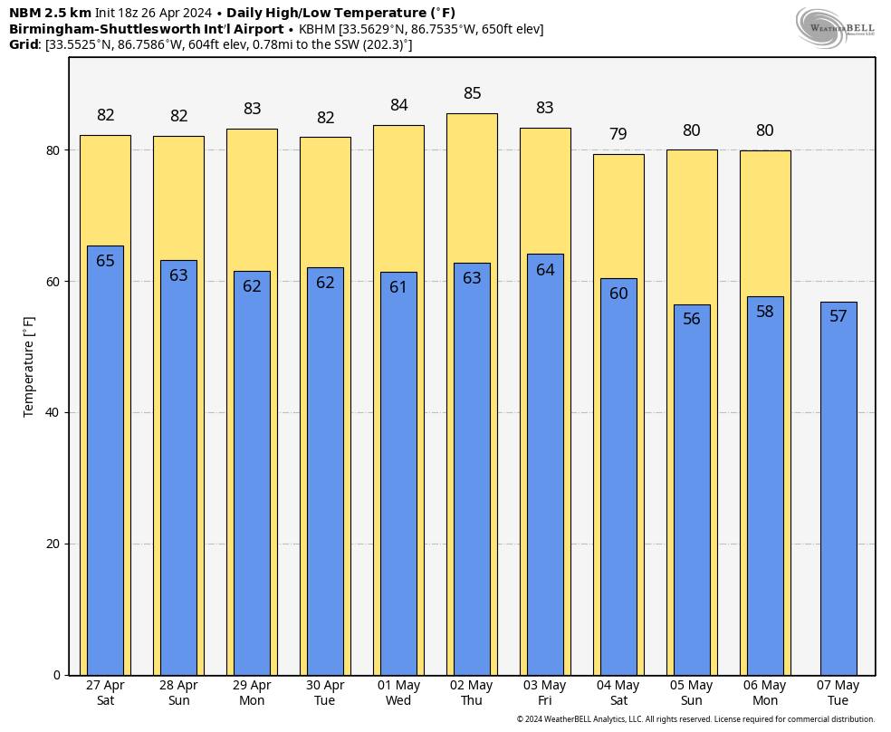
THIS AFTERNOON: The weather is warm and dry across Alabama this afternoon, with temperatures in the 80s. Tonight will be mostly fair with a low in the 60s.
THE WEEKEND: Highs will remain in the 80s Saturday and Sunday with partly sunny days and fair nights. Showers will be very hard to find; the chance of any one spot getting wet each day is less than 10%.
NEXT WEEK: A weak front will bring some risk of showers to north and west Alabama Monday night and Tuesday, but with an upper ridge in place, rain amounts will be light and spotty. The front will stall and ultimately dissipate by midweek; a few isolated showers are possible over the northern half of the state each day Wednesday through Friday, but the rain won’t be heavy or widespread. Most of south Alabama will be dry, and highs remain in the low to mid 80s through the week.
We still see no sign of a high-impact weather event for Alabama for the next seven to 10 days.
ON THIS DATE IN 1978: An unusually strong occluded front swept out of the Gulf of Alaska and produced the first April thunderstorm of record at Fairbanks. Pea-sized hail fell northeast of Fairbanks from thunderstorms whose tops were less than 8,000 feet.
ON THIS DATE IN 2011: The multiple-day “Superoutbreak” of tornadoes continued. Fifty-five tornadoes were confirmed on April 26, although no fatalities occurred. Most of those tornadoes were short lived, but a few of them caused considerable damage. A long-tracked wedge tornado caused EF2 damage in rural Texas and Louisiana. An EF3 tornado destroyed structures and caused severe damage at Fort Campbell, Kentucky, as well.
In Alabama, we were warning people of the potential of violent, long-track tornadoes on the following day, April 27.
For more weather news and information from James Spann and his team, visit AlabamaWx.


