James Spann: Mostly dry Monday with a few storms for southeast Alabama
James Spann forecasts dry weather for most of Alabama Monday and Tuesday from Alabama News Center on Vimeo.
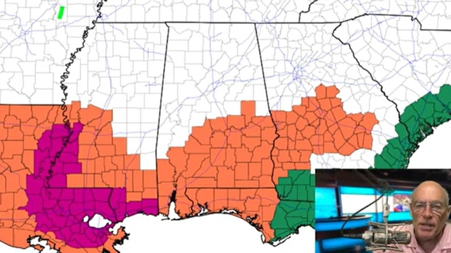
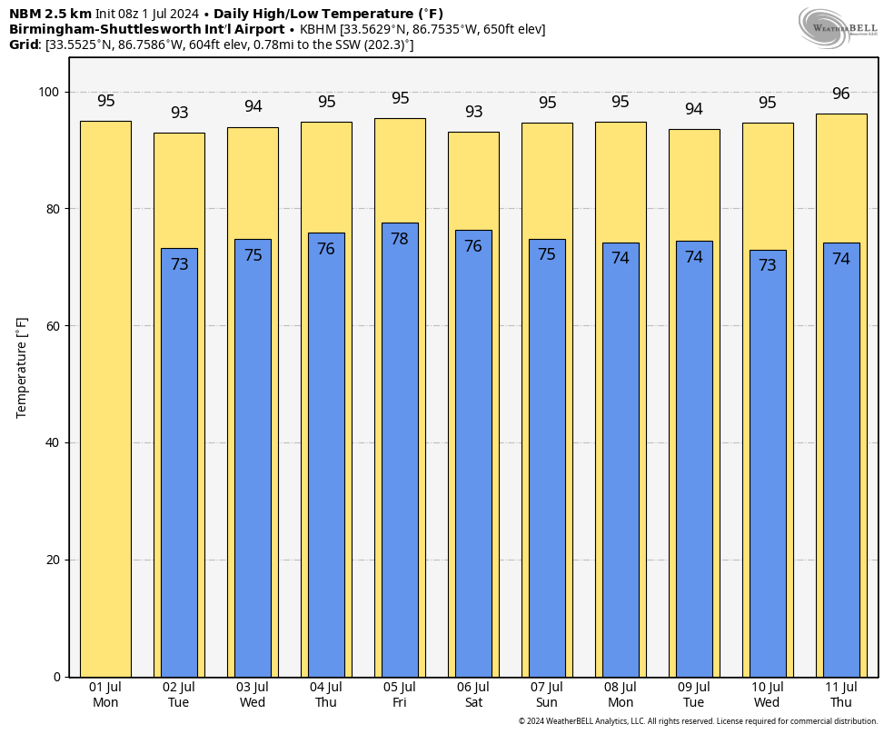
HOT SUMMER DAYS: Drier air will creep into the northern two-thirds of Alabama today, and most of the afternoon showers and storms will be confined to the southeast counties. Where storms do form across southeast Alabama this afternoon, they could be strong, with gusty winds. Highs will be in the 90s this afternoon.
The weather won’t change much through Wednesday; afternoon showers will be few and far between with highs mostly in the mid 90s.
Scattered showers and storms will become more numerous across Alabama Thursday and Friday as the air becomes more unstable and moisture levels rise. The chance of any one spot getting wet these days is 30-40%, and highs will remain in the 90s.
THE ALABAMA WEEKEND: Classic summer weather continues — partly sunny, hot, humid days with scattered, mostly afternoon and evening showers and thunderstorms Saturday and Sunday. Highs will be between 92 and 96 degrees.
We don’t see any real change next week as we roll with a persistence forecast — hot and humid, with a few spotty showers and thunderstorms daily and highs in the 90s and lows in the 70s.
TROPICS: Short-lived Tropical Storm Chris moved into Mexico early this morning with potential for heavy rain. Out in the Central Atlantic, Invest 96L has a high chance of becoming a tropical depression or storm this week. It will move into the Caribbean by the weekend.
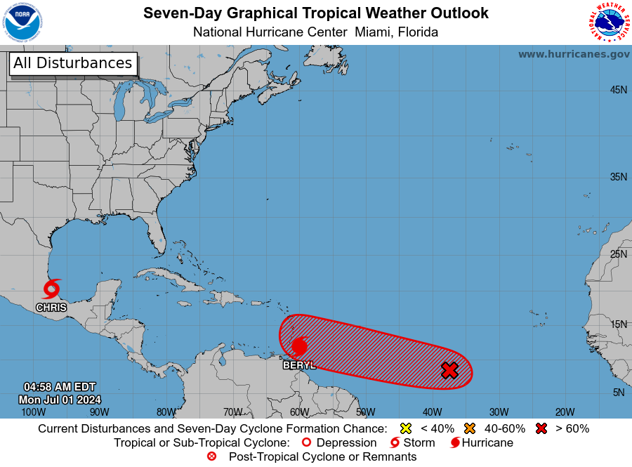
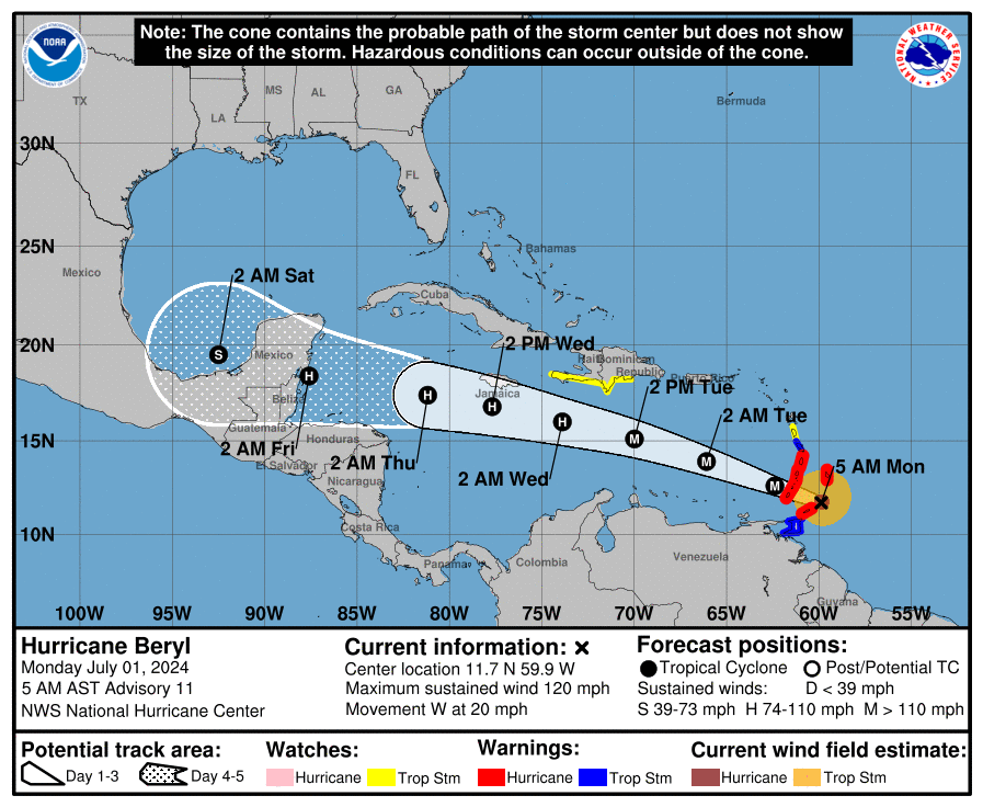
Hurricane Beryl is a bit weaker this morning, with sustained winds of 120 mph — still a dangerous Category 3 hurricane. It will move through the Windward Islands this morning, followed by a path across the Caribbean. Beryl will be just south of Jamaica Wednesday and then is forecast to move into either Belize or Mexico’s Yucatan Peninsula late Thursday night.
It will weaken to a tropical storm over land before moving into the Bay of Campeche Friday night. From there, long-range model consensus suggests a track into Mexico, but some of the ensemble members introduce a northward component of motion, which could put south Texas in play. It’s still too early to call Beryl’s final destination, but we expect no impact for the central Gulf Coast (Gulf Shores to Panama City Beach).
ON THIS DATE IN 2002: San Antonio, Texas, recorded 9.52 inches of rain to set a new record for its greatest rainfall for the entire month of July.
For more weather news and information from James Spann and his team, visit AlabamaWx.


