James Spann: Beneficial rain for south Alabama today, drier air for the weekend
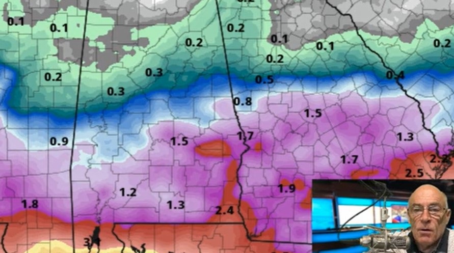
RADAR CHECK: Rain is relatively widespread this morning across Alabama south of I-20 and west of I-65. Rain will continue to expand this morning, but the most widespread coverage and heavier totals will be over the southern half of the state, thanks to a weak low moving through the northern Gulf of Mexico. Most south Alabama communities can expect 1-2 inches over the next 24 hours, but for places like Tuscaloosa, Birmingham, Anniston and Gadsden the amounts will be generally one-quarter inch or less. Some communities across the Tennessee Valley will miss the rain completely.
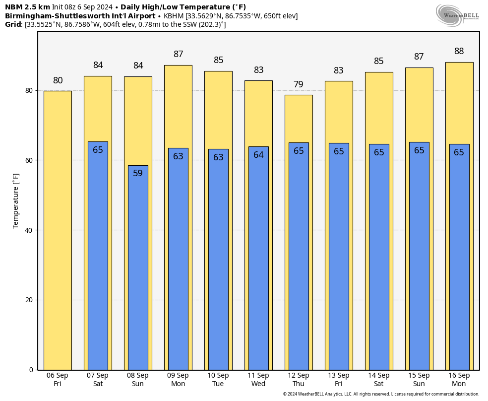
Temperatures will hold in the 70s for most places today thanks to clouds and rain.
 THE ALABAMA WEEKEND: A surface front will move through the state Saturday with some risk of isolated showers; the best chance of rain will be near the Gulf Coast. But for most of the state the day will be dry with a partly sunny sky and highs in the 80s. Any showers on Sunday will be confined to the coast; otherwise, expect a partly to mostly sunny sky with highs remaining in the 80s. Most places across north Alabama will start the day in the 50s.
NEXT WEEK: The weather will be generally rain-free Monday through Wednesday, although a few showers will remain possible near the Gulf Coast and across far south Alabama. There is some potential for increasing rain chances statewide by Thursday and Friday with a weak low approaching from the south, but model output is very inconsistent and forecast confidence is low. Highs will be in the 80s through the week.
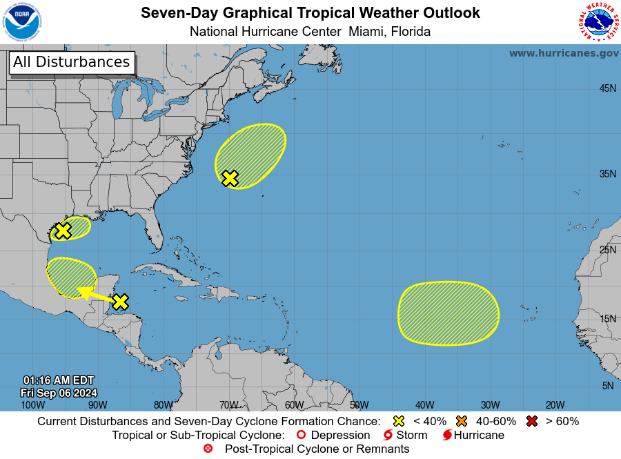
 TROPICS: The National Hurricane Center (NHC) continues to monitor several areas of interest across the Atlantic basin, but all of them have only a low chance of development. These are the two we are watching:
- Shower and thunderstorm activity has diminished in association with a broad area of low pressure and a nearby weak front over the northwestern Gulf of Mexico. Upper-level winds are expected to remain unfavorable for significant development of this system while it meanders over the northwestern Gulf and eventually merges with an approaching frontal system later today or Saturday. Although tropical cyclone development is unlikely, heavy rainfall is expected to continue across portions of the northern Gulf Coast during the next day or so. The chance of development is only 10%.
- Disorganized showers and thunderstorms over the northwestern Caribbean Sea are associated with a tropical wave. Development is not expected before the system reaches Belize and the Yucatan Peninsula later today. Some slow development is possible later this weekend after the system emerges over the southwestern Gulf of Mexico. The chance of development is 20%.
FOOTBALL WEATHER: For high school games across the state tonight, some light rain is possible, if not likely, over the southern two-thirds of the state. We’re not expecting any lightning, however, and temperatures will be in the 70s.
On Saturday, Auburn will host California at Jordan-Hare Stadium (2:30 p.m. kickoff). The sky will be partly sunny, and a brief shower can’t be ruled out. Temperatures will hover in the low to mid 80s during the game.
Alabama will host South Florida Saturday in Tuscaloosa (6 p.m. kickoff). The sky will be mostly clear with temperatures falling from the low 80s at kickoff into the upper 60s by the final whistle.
UAB will be on the road, taking on Louisiana-Monroe Saturday (6 p.m. kickoff). The sky will be clear with about 83 degrees at kickoff; temperatures drop to near 70 degrees by the fourth quarter.
ON THIS DATE IN 1776: The Pointe-à-Pitre hurricane is one of the deadliest Atlantic hurricanes on record. While the intensity and complete track are unknown, this storm struck Guadeloupe, killing 6,000.
ON THIS DATE IN 2017: Category 5 Hurricane Irma affected the U.S. Virgin Islands and Puerto Rico. Maximum sustained winds were at 180 mph when the storm hit St. Thomas and St. John. Catastrophic damage was reported over the U.S. Virgin Islands and significant damage over Puerto Rico, especially Culebra.
For more weather news and information from James Spann and his team, visit AlabamaWx.


