Scott Martin: High-impact severe weather for Alabama today and into early Sunday morning
HIGH RISK OF SEVERE STORMS TODAY: The wave of storms we will be dealing with today will not come in the form you have been used to seeing during the winter. These storms will be supercellular in form and not part of a squall line with embedded damaging wind gusts and isolated smaller tornadoes. Today’s threat will be for the potential of strong, long-track tornadoes of EF2 strength or greater, along with damaging wind downbursts up to and exceeding 70 mph and large hail up to 2 inches in diameter. Along with that, some locations could see 2-3 inches of rainfall, with isolated pockets of 4 inches and greater, due to heavy thunderstorms.
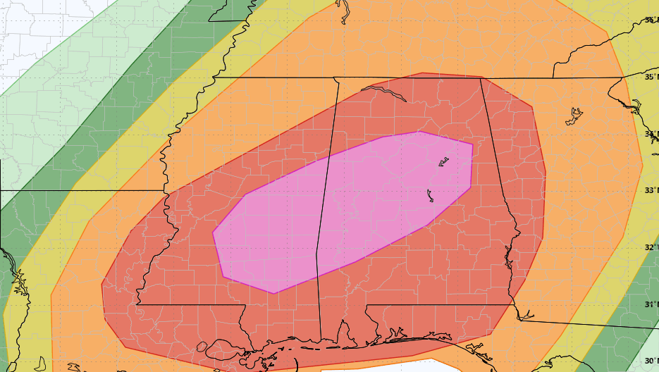
The Storm Prediction Center has a high risk (level 5 of 5) up for locations inside a line from just north of Fayette to Hanceville to Jacksonville to Alexander City to Prattville to just north of Grove Hill. This includes Anniston, Birmingham, Talladega, Hoover, Tuscaloosa, Clanton, Demopolis and Selma.
A moderate risk (level 4) is up for the rest of the state except for locations north of a line from Pogo to Florence to Veto in extreme northwest Alabama. Those locations are in an enhanced risk (level 3) through Saturday and into very early Sunday.
TIMING: For the western third of the state, storms could fire up as early as 11 a.m., with the end of the event moving through around 9 p.m. For the central third, the window will start around 2 p.m. and come to an end by 11 p.m. For the eastern third, not including extreme southeast Alabama, the threat window will be from 4 p.m. today to 1 a.m. Sunday. And for the extreme southeastern parts of the state, from 6 p.m. this evening to 3 a.m. Sunday. Again, threats include strong, long-tracked tornadoes, damaging straight-line winds and hail up to 2 inches in size.
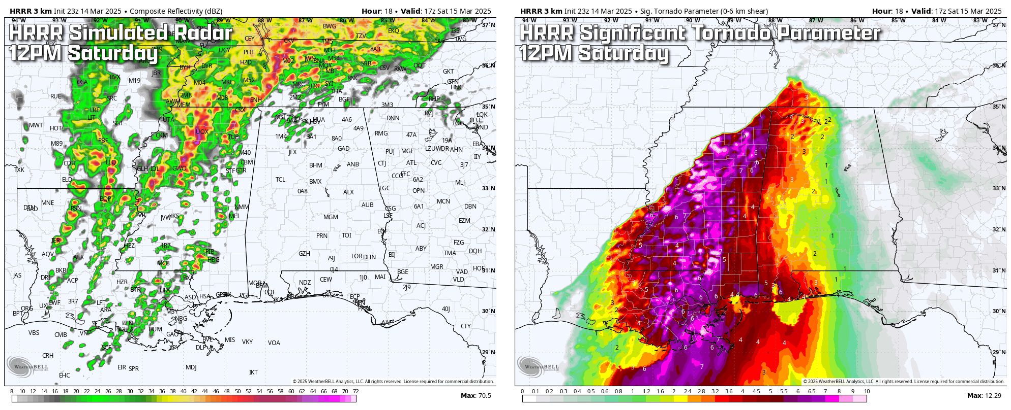
At noon today, most of the morning storms should be out of the state, but this is when we expect supercells to start forming well out ahead of the front and moving into west Alabama. At that time, we see conditions starting to become favorable for severe storms.
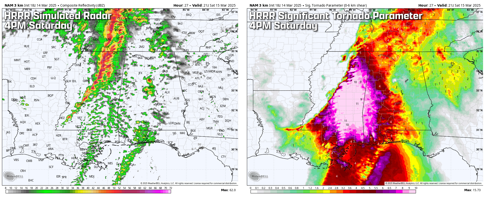
As we move on to 4 p.m., we see potential for multiple supercells in Alabama and a line of supercells back to our west in Mississippi. Significant Tornado Parameter (STP) values on this model run have maxed out, with values up to 10 and 11 over the eastern half of Mississippi and bleeding over the state line into Alabama. This is where we will really need to start keeping an eye out for those long-track, strong tornadoes; at this point, any storm that forms may go quickly severe with a risk of becoming tornadic.
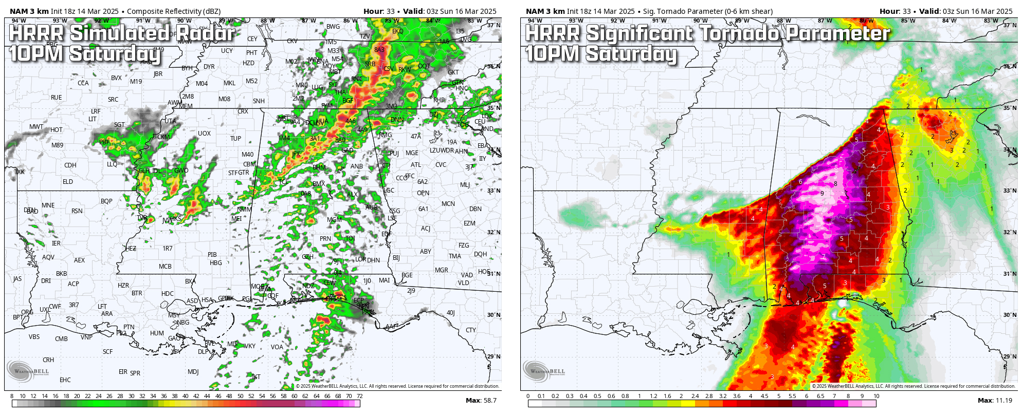
By 10 p.m., nearly all the severe activity will have shifted into Alabama out of Mississippi, and while the higher threat of damaging winds look to be along the front in the northern parts of the state, the risk for supercells will continue south of the I-59 corridor. We continue to have nearly maximized STP values through the central third of the state, reaching as high as 9. The rest of the state will still have an increased risk of significant tornadoes, but there is a steep drop-off to zero just north of the I-59 corridor, where the front should be.
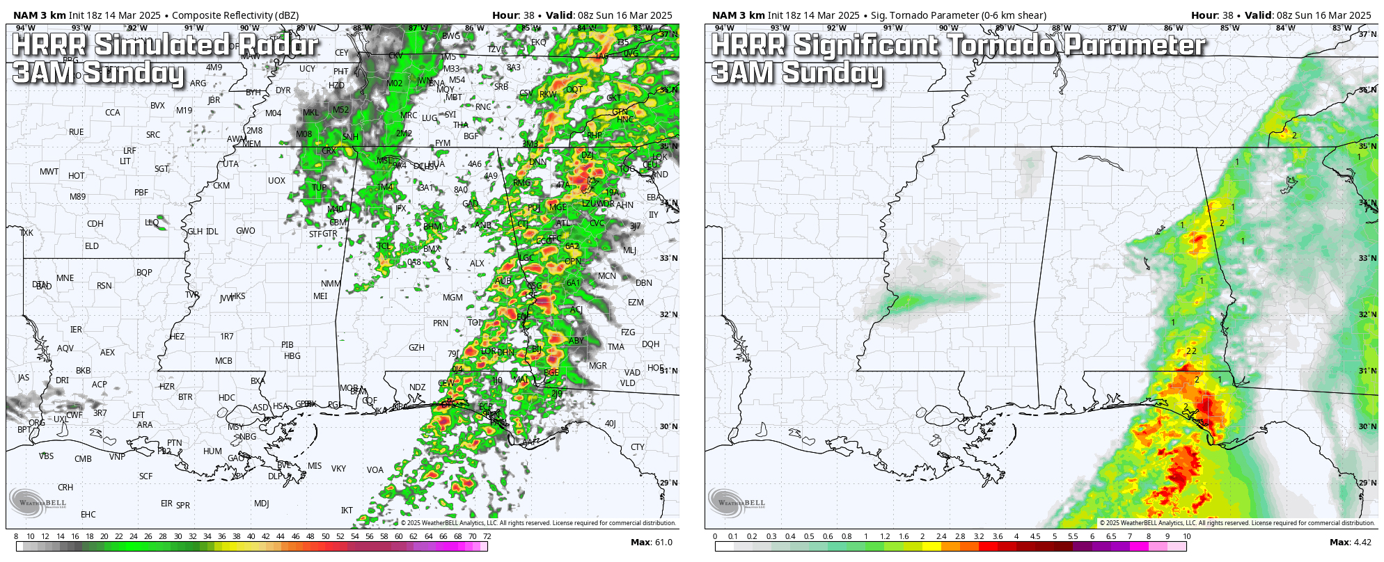
By 3 a.m. Sunday, much of the rain and storms will have pushed into Georgia, except for the southeast corner of Alabama. We look to have some wrap-around showers well behind the main activity, but these will be general showers. By this time, the severe threat will have really weakened, with STP values down to 3 and less. While a significant tornado is still possible with those values, the odds will be much less than what we may see earlier.
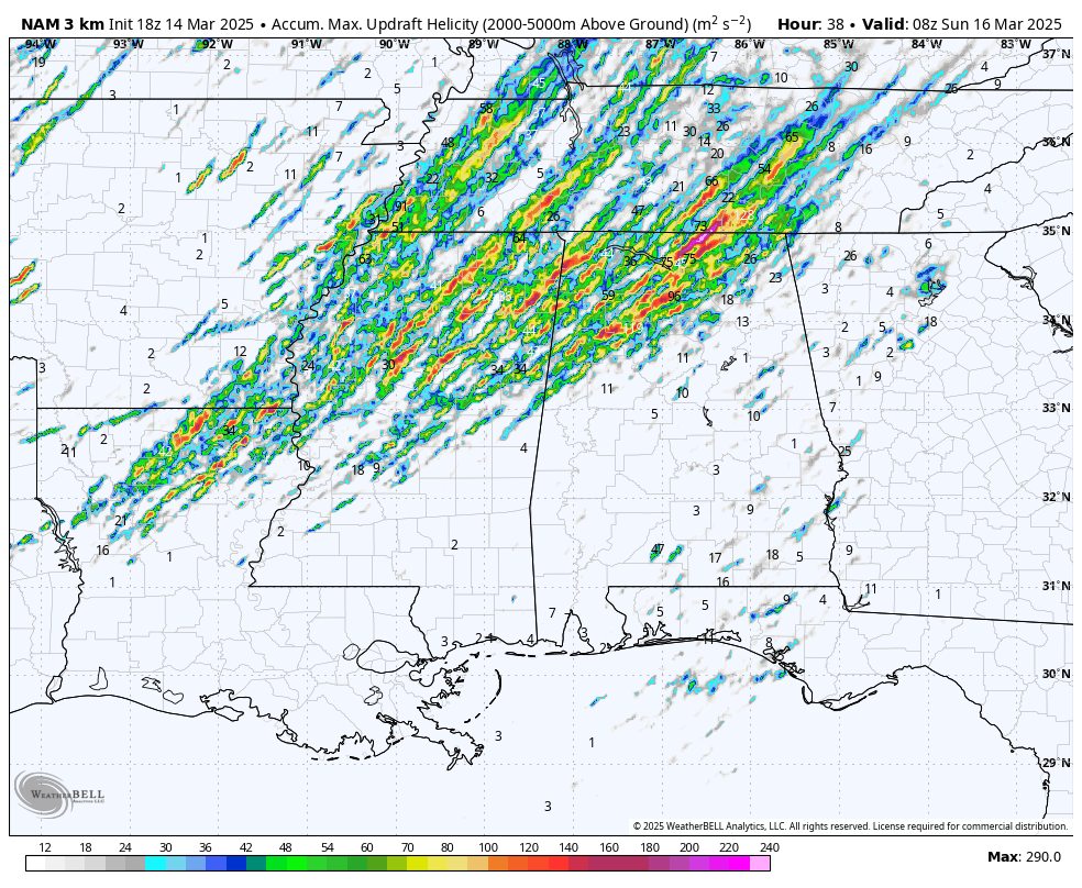 OTHER FACTORS: While we have seen the STP values highest in the southern half of the state throughout the event, the updraft helicity tracks that high-resolution models put out show the best chance of rotating updrafts over northern and northwestern Alabama. However, there are tracks south of that, showing rotating updrafts possible statewide.
We’ll have plenty of instability in place, and with the perfect mix of increased humidity, wind shear and lapse rates, the ingredients will be there for severe weather to build and stick around. Some locations may get plenty of sunshine before the storms form in the afternoon, and highs will reach the lower 70s to the mid 80s from northwest to southeast. Also, it will be quite breezy outside the storms, and a wind advisory is in effect until 1 a.m. Sunday.
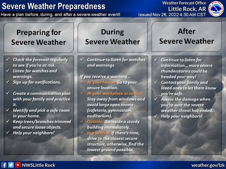
HAVE A PLAN: Folks, we are staring down the barrel of a significant severe weather outbreak, and now is the time to get your plan in place. We are expecting the potential for strong, long-track tornadoes, which means these storms could stay on the ground for miles, causing extreme damage. This is the kind of setup where you do not want to wait until a warning is issued to figure out where you’re going to take shelter. You need to be ready to act immediately.
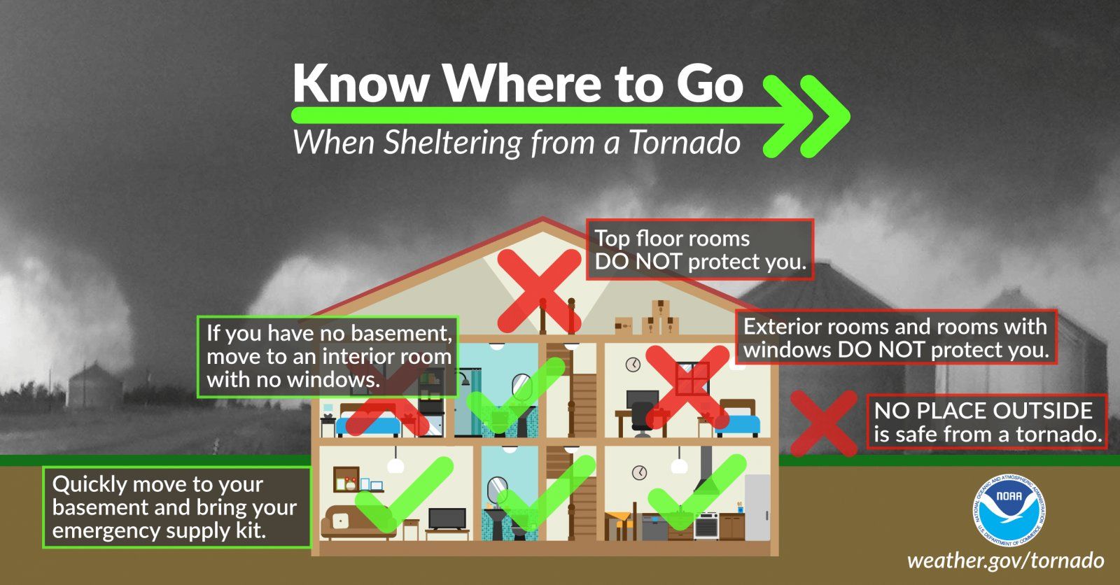
WHERE TO SEEK SHELTER: If you live in a house or apartment: Get to the lowest level, put as many walls between you and the outside as possible and get into a small, windowless interior room like a bathroom, closet or hallway. A basement or storm shelter is best.
If you live in a mobile or manufactured home, you cannot stay there. Even a weak tornado can destroy a mobile home. If a tornado watch is issued, make arrangements to go to a sturdy, site-built structure well ahead of time. Do not wait until the warning — leave early.
If you’re in a car or caught outside, drive to the nearest sturdy building and get inside. Do not seek shelter under a highway overpass. If no shelter is available, lie flat in a low-lying area and cover your head.
WHAT TO HAVE READY:
- A fully charged phone – Make sure you can get emergency alerts, check radar and communicate if needed.
- Flashlights with fresh batteries – Tornadoes often strike at night, and power outages are likely.
- A NOAA Weather Radio – This could save your life if storms hit while you’re asleep.
- Helmets and sturdy shoes – Protect your head and feet in case of debris.
- Emergency supplies – Water, snacks, medications and anything else you may need if you have to take shelter for a while.
This is not a drill, and it’s not a typical spring storm. This is the kind of outbreak that can change lives in an instant. Have your severe weather safety plan locked in and be ready to act immediately when warnings are issued. Reach out to your family, friends and especially the elderly or those who may not have access to weather alerts. Make sure they know about the very high risk of life-changing severe storms and help them prepare if needed. Stay safe and stay alert.
MUCH CALMER SUNDAY: Much nicer and slightly cooler conditions will move in on Sunday. Skies will begin to clear, but several wrap-around clouds will move through and may even squeeze out a stray shower or two. Highs will be in the lower 60s to the upper 70s.
THE WORK WEEK: Ridging starts to build on Monday, reinforcing the dry air moving in. Skies will be sunny and highs in the upper 50s to the upper 60s. Tuesday will continue the streak of dry weather. However, a few clouds will move through the state, and we’ll have partly to mostly sunny skies. Highs will be warmer, back up in the lower to mid 70s.
On Wednesday, a deep trough will swing a cold front in our direction and will move into the state late in the day. While a few scattered showers and maybe a few rumbles will be possible, this is definitely not a severe look. Before the front moves in, highs will top out in the 70s statewide.
Skies will quickly clear out behind the front on Thursday, and afternoon highs will be much cooler, reaching only the mid 50s to the upper 60s. Clouds will begin moving back into the state on Friday as another system moves in our direction. For now, models show we stay dry through the day, but skies will be partly to mostly cloudy for much of the state. Highs will be warmer, reaching the lower 60s to the lower 70s.
For more weather news and information from James Spann, Scott Martin and other members of the James Spann team, including frequent updates on today’s severe weather, visit AlabamaWx.


