James Spann: Strong storms for Alabama early Friday, then colder days ahead
NICE THURSDAY AFTERNOON: Temperatures are in the mid 70s across Alabama this afternoon with a good supply of sunshine; doesn’t get much better. But enjoy it, because some big changes are coming up in the days ahead.
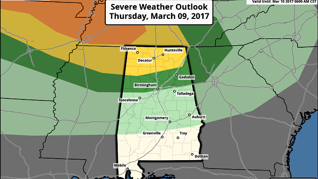
STRONG STORMS EARLY TOMORROW: Clouds move in tonight ahead of a cold front, and we expect a band of strong storms in here during the pre-dawn hours tomorrow. The Storm Prediction Center now has a “slight risk” of severe storms up for the Tennessee Valley of far North Alabama, with a “marginal risk” as far south as Birmingham in its outlook that runs through 6 a.m. tomorrow.

TIMING: The main window for strong storms is between 1 a.m. and 7 a.m. The best chance of severe storms will be over far North Alabama across the Tennessee Valley; they should be weakening as they move southward toward Birmingham, Tuscaloosa, Anniston and Gadsden.
THREATS: Heavier storms after midnight over North Alabama will be capable of producing some hail and strong, gusty winds. The tornado threat for now looks low.
RAIN: Amounts should be less than one-half inch for most places, and flooding won’t be a problem.
The sky will become mostly sunny tomorrow as drier air slips into the state following the front; temperatures will be about 10 degrees cooler than today, with a high in the 60s.
THE WEEKEND: Looks like most of the day Saturday will be dry; some morning sunshine is possible, but clouds will move in during the afternoon. The high Saturday afternoon will be in the 57- to 60-degree range.
Then a cold, soaking rain is likely Saturday night as a wave of low pressure moves across the state. No severe weather worries with temperatures in the 40s in most places as the rain falls. The main window for rain will come from about 5 p.m. Saturday through 8 a.m. Sunday. Rain amounts of one-half to 1 inch are likely.
SNOW TO THE NORTH: Much of Tennessee will have a chance of some accumulating snow as Arctic air settles southward into the Volunteer State. One to 2 inches of snow is possible in spots, and some driving problems could develop early Sunday morning as temperatures go below freezing.
And yes, a slushy “wintry mix” could develop down into far North Alabama after midnight Saturday night into early Sunday morning, but for now the chance of accumulation looks small; the best chance of seeing a little on the ground will be across high elevations, especially more than 1,000 feet. But, as always, you want to watch these March setups closely for surprises. The best chance of seeing a few snowflakes or ice pellets early Sunday will be along and north of the Tennessee River.

After the rain, Sunday will be breezy, cold and raw, with most places not getting out of the 40s. The sky will stay mostly cloudy, although some late-afternoon clearing is possible.
NEXT WEEK: A clipper system will bring yet another shot of cold air into Alabama Tuesday; we might even see a few flurries over the northern third of the state Tuesday morning as the cold air rushes in. Tuesday’s high will be only in the 40s, and there is a good chance we drop into the 20s by Wednesday morning, with a clear sky and calmer wind. Then, some rain will return late in the week.

WEATHER BRAINS: You can listen to our weekly 90-minute netcast anytime on the web, or on iTunes. This is the show all about weather featuring many familiar voices, including meteorologists at ABC 33/40.
CONNECT: You can find me on all of the major social networks:
Facebook
Twitter
Google Plus
Instagram
Pinterest
Snapchat: spannwx
For more weather news and information, visit AlabamaWX.


