James Spann: Rain moves out later today; more storms for Alabama Wednesday
James Spann: Wet, stormy day for Alabama, then quiet tomorrow from Alabama NewsCenter on Vimeo.
RADAR CHECK: A large mass of rain and thunderstorms is over much of Alabama early this morning. Thankfully, there is no surface-based instability over the northern half of the state, and little if any risk of severe storms. However, a severe thunderstorm watch remains in effect for parts of Central Alabama (south of I-20) until 11 a.m., and a tornado watch is in effect for far South Alabama until 1 p.m.

Storms that move through Central Alabama will be capable of producing strong, gusty winds and hail; a few isolated tornadoes are possible over far South Alabama.

Some localized flooding is possible this morning as well (we have some now in the Birmingham metro), but no widespread, major flash flooding is expected. Quite frankly, this is a very beneficial rain event for a part of the state still in drought conditions.
Rain will end from west to east later this morning, and much of the afternoon will be dry. It is important to note we have some potential for “wake low” on the back edge of the rain; these kind of winds are not related to thunderstorm, but a deep pressure couplet that can bring wind gusts to 40/50 mph (this happened in Arkansas last night). This is not a certainty, but a possibility. We will be watching reports closely on the back edge of the rain.
REDEVELOPMENT LATE TODAY: A few additional showers could form along a cold front late this afternoon over North Alabama, but the air is totally worked over this morning by the big mass of rain and storms, and there is no severe weather threat. We should reach the upper 70s this afternoon with some sun.
TOMORROW: The day will be warm and dry; with a good supply of sunshine, we rise into the low 80s.
SEVERE WEATHER THREAT WEDNESDAY: The “wave train” keeps cranking them out; the next one will bring the threat of strong to severe storms to Alabama Wednesday. We really need to get the storms today out of here before we can focus on this next threat, but it looks this way now:
Morning storms are a good possibility Wednesday with a northward-moving warm front. These storms should be elevated, but they could still bring the possibility of hail and strong winds.
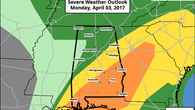
New storms should form Wednesday afternoon in an environment very favorable for severe weather. Surface-based instability values are forecast to soar into the 2,500-3,500 j/kg range, with fairly robust bulk shear values as well. Storms that form during the afternoon and evening hours will have the potential to produce large hail, damaging winds and a few tornadoes — maybe even a strong tornado. The highest threat during the afternoon will be east of a line from Centre to Selma to Mobile, where the Storm Prediction Center has already defined an “enhanced risk” of severe storms.

Hopefully the morning storms will somewhat mitigate the severe threat Wednesday afternoon, but that remains to be seen. We will have a much better look at the setup later today and tomorrow.
LATE-SEASON COLD SNAP: Thursday will be breezy and much cooler; clouds could linger a decent part of the day with temperatures holding in the 50s. And it sure looks like we are headed for the 30s early Friday and Saturday morning. The coldest temperatures should come at daybreak Saturday, with frost potential across much of North and Central Alabama, and also the possibility of a freeze for colder spots. Growers beware.
The day Friday will be sunny with a high in the low 60s.
THE WEEKEND: After the frosty start early Saturday, the weekend will feature sunny weather both days. The high Saturday will be in the upper 60s, followed by mid 70s Sunday.
Click here to see the Beach Forecast Center page.
STORM SPOTTER TRAINING: We will be on the road through April offering free storm spotter classes. We need more trained spotters in Alabama. By attending, you can make the severe weather warning process better. No need to register; just come with a curious mind. And there is no age limit; kids who love weather will enjoy it. You will never look at a storm the same again. The next training is in Tuscaloosa tomorrow evening at 6:30 at Shelton State Community College.
WEATHER BRAINS: You can listen to our weekly 90-minute netcast anytime on the web, or on iTunes. This is the show all about weather featuring many familiar voices, including meteorologists at ABC 33/40. We will produce this week’s show tonight at 8:30. You can watch it live here.
CONNECT: You can find me on all of the major social networks:
Facebook
Twitter
Google Plus
Instagram
Pinterest
Snapchat: spannwx
For more weather news and information, visit AlabamaWX.


