James Spann: Warmer afternoons ahead for Alabama
James Spann: More like summer in Alabama by midweek from Alabama NewsCenter on Vimeo.
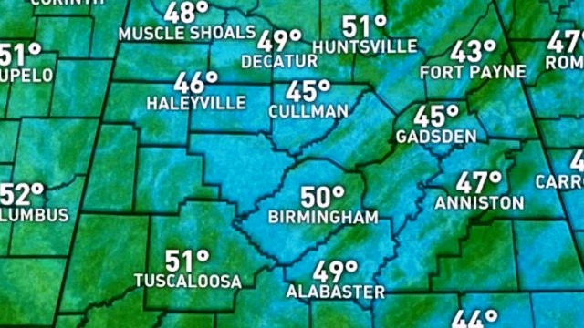
COOL MORNING: Temperatures were down in the 40s across much of north and central Alabama early this morning; our Skywatcher at Black Creek, just northeast of Gadsden, reported a chilly 40 degrees just before sunrise. Fort Payne was at 43, with Cullman and Gadsden reporting 45. We warm nicely today with a strong May sun; most communities will reach the low 80s this afternoon.
MIDWEEK SUMMER PREVIEW: Look for a summer preview with very warm afternoons. Highs will be up in the 85- to 89-degree range tomorrow through Thursday, with a good supply of sunshine each day.
RAIN RETURNS LATE IN THE WEEK: Clouds increase Thursday night, and rain comes Friday. Looks like the best chance will come Friday afternoon and Friday night, with potential for about one-half to 1 inch of rain for the northern half of the state. Thunderstorms are very possible, but for now the overall severe weather threat looks pretty limited with questionable instability. The high Friday afternoon will be back down in the 70s because of clouds and rain.
THE ALABAMA WEEKEND: The sky becomes mostly sunny Saturday as dry air returns to the state; Saturday’s high should be in the mid to upper 70s. Sunday will bring blue sky and sunshine with a high in the low 80s.
NEXT WEEK: Warm, dry weather continues through the first half of the week; it seems like the next chance of wet weather will come Wednesday night or Thursday.

Click here to see the Beach Forecast Center page.
WEATHER BRAINS: You can listen to our weekly 90-minute netcast anytime on the web, or on iTunes. This is the show all about weather featuring many familiar voices, including meteorologists at ABC 33/40. We will produce this week’s show tonight at 8:30. You can watch it live here.
CONNECT: You can find me on all of the major social networks:
Facebook
Twitter
Google Plus
Instagram
Pinterest
Snapchat: spannwx
For more weather news and information, visit AlabamaWX.


