Brian Peters: Warm, dry start for Alabama’s Memorial Day weekend
Brian Peters: Alabama stays dry today, gets wet on Memorial Day from Alabama NewsCenter on Vimeo.
TODAY AND SUNDAY: Partly cloudy skies are expected across Central Alabama for the first day of the Memorial Day weekend, with highs in the middle 80s. While our weather is very nice, a weak frontal system draped across the Mid-South is producing thunderstorms in northeast Arkansas, where a severe thunderstorm watch is in effect through noon. The upper ridge pushing northward from the Gulf of Mexico is expected to keep the active weather north of Central Alabama today.
The front is forecast to remain weak and north of us on Sunday, so highs will again top out in the middle and upper 80s.
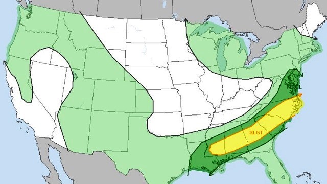
WET MEMORIAL DAY: A strong upper trough over the western Great Lakes will dampen the ridge and nudge it eastward Monday. This upper-air change will allow the front to sag into the Southeast, forcing rain chances up significantly. Looks like Memorial Day could be fairly wet, with showers and thunderstorms. The Storm Prediction Center has an area of slight risk along the front from southern Mississippi to the Carolinas, which includes a chunk of Central and South Alabama. Temperatures remain warm but reduced slightly, with highs mainly in the lower 80s.

REST OF THE WEEK: The upper air pattern does not change a great deal through Thursday, so with a dissipating frontal boundary in the area, you can expect to see showers and thunderstorms each day driven primarily by the heat of the day. We won’t see much change in daily highs, either, with readings in the lower 80s. While the pattern does not suggest rainfall amounts nearly as high as we saw last week, it does suggest the potential for some additional beneficial rains.

An upper ridge, albeit a weak one, begins to become the primary player in the upper air pattern for us next Friday and Saturday. This will help to raise high temperatures into the middle 80s, but it is unlikely to do much to change the daily threat of showers and thunderstorms.
BEYOND NEXT WEEK: Looking out into voodoo country, the Global Forecast System keeps the Southeast just to the east of an upper ridge. That ridge axis stays just to our west, so the long-range temperature outlook is for warm but not exceedingly hot temperatures and summer-like shower potential.
HURRICANE SEASON NEARS: The National Hurricane Center has posted its seasonal outlook for the 2017 hurricane season, which begins in just five days. It’s interesting to note that the NHC forecast calls for above-normal activity, while the forecast out of Colorado State calls for below-normal activity. But no matter what the seasonal outlooks say, it is imperative that everyone along the Gulf and Atlantic coasts prepare, because it takes only one storm affecting your area to produce significant risk to life and property.

SEC BASEBALL: The SEC Baseball Tournament continues through Sunday at the Hoover Met. Come see some of the best college players in the country as they compete for the championship. Also, for the first time ever, you can take advantage of the Hoover Metropolitan Complex, which will feature a free, indoor Fan Fest – Ferris wheel, sports bar and much more. Tickets start at $9. We expect warm, dry weather at the Hoover Met today, with highs in the 80s. There is just a small risk of showers Sunday afternoon for the championship game. Sunday’s high will be between 85 and 88.
Click here to see the Beach Forecast Center page.
Enjoy your weekend. Godspeed.

For more weather news and information, visit Alabama WX.


